

Infrastructure Delivery Plan (Feb 2013) - Runnymede Borough Council
Infrastructure Delivery Plan (Feb 2013) - Runnymede Borough Council
Infrastructure Delivery Plan (Feb 2013) - Runnymede Borough Council

Create successful ePaper yourself
Turn your PDF publications into a flip-book with our unique Google optimized e-Paper software.
<strong>Runnymede</strong> <strong>Borough</strong> <strong>Council</strong>s Sustainable Community Strategy (2012)<br />
2.11 The <strong>Council</strong>’s SCS has directed that the Local <strong>Plan</strong> brings forward policies that provide<br />
for the regeneration of Addlestone, Chertsey, Egham, Virginia Water, and the<br />
development of the former DERA site. In terms of the redevelopment of the former<br />
DERA site, it states that the site provides a unique opportunity to provide a mixed use<br />
community with:<br />
Spatial Context<br />
• headquarter development for a global high-tech enterprise;<br />
• a new sustainable ‘village’ with homes of varying size and tenure which meet<br />
the housing needs of the <strong>Borough</strong>; and,<br />
• modern sustainable infrastructure as well as a site of major employment<br />
opportunity.<br />
2.12 <strong>Runnymede</strong> is located in north-west Surrey, some twenty miles south-west of Central<br />
London in the South East Region. Covering an area of some 7804 hectares, its<br />
northern and eastern boundaries are formed by the River Thames and River Wey.<br />
Three bridges at various points across the Thames and two motorway bridges connect<br />
the <strong>Borough</strong> to Staines, Chertsey, and Weybridge. Nearby towns in adjoining <strong>Borough</strong>s<br />
include Staines, Weybridge, Windsor, Woking, and Camberley.<br />
2.13 The west of the <strong>Borough</strong> is mainly rural in character whilst the main urban centres of<br />
Egham, Chertsey, and Addlestone are situated in its eastern half. There are also a<br />
number of smaller settlements including Virginia Water, Woodham, New Haw,<br />
Ottershaw, Row Town, and Englefield Green. <strong>Runnymede</strong> is situated within the London<br />
Green Belt, and Green Belt covers about 78% of the total area.<br />
Population<br />
2.14 Between 1991 and 2001 there was a population growth rate of 5% in the <strong>Borough</strong>,<br />
mainly due to net inward migration rather than natural increase. At the time of the 2001<br />
Census, there were 31,686 households in the <strong>Borough</strong>, accommodating a population of<br />
78,033.<br />
2.15 Surrey's population (and <strong>Runnymede</strong>’s as a <strong>Borough</strong>) is projected to continue to rise,<br />
with notable increases in the number of older people. Specifically, the 2010 National<br />
Population projections (Office for National Statistics) estimate that the population of<br />
<strong>Runnymede</strong> will reach some 98,000 people by the end of the plan period.<br />
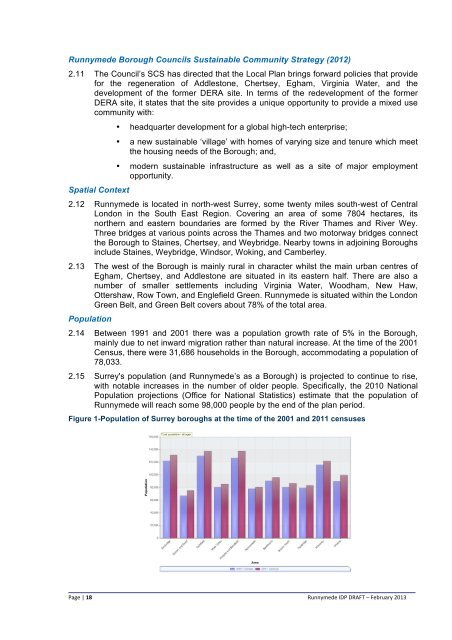
Figure 1-Population of Surrey boroughs at the time of the 2001 and 2011 censuses<br />
Page | 18<br />
<strong>Runnymede</strong> IDP DRAFT – <strong>Feb</strong>ruary <strong>2013</strong>


