Evaluating Alternative Operations Strategies to Improve Travel Time ...
Evaluating Alternative Operations Strategies to Improve Travel Time ...
Evaluating Alternative Operations Strategies to Improve Travel Time ...

You also want an ePaper? Increase the reach of your titles
YUMPU automatically turns print PDFs into web optimized ePapers that Google loves.
SHRP 2 L11: Final Appendices<br />
and can have a positive impact on the reliability of trips for individual travelers. <strong>Travel</strong>ers can take<br />
a de<strong>to</strong>ur, change destination, or communicate their situation <strong>to</strong> others in the case of time-sensitive<br />
commitments. The ability of traveler information <strong>to</strong> improve trip reliability will increase as<br />
technology and avenues for transmitting traveler information improve traveler information.<br />
Additional information about traveler information systems can be found in the NCHRP Synthesis<br />
399 – Real <strong>Time</strong> <strong>Travel</strong>er Information Systems (13) report.<br />
Pre-trip information by 511, real-time navigation systems, web sites, subscription alerts. Pretrip<br />
information provides mo<strong>to</strong>rists data through the internet, television, or radio. Many Cities have<br />
Advanced <strong>Travel</strong>er Information Systems (ATIS) with growing sophistication. These systems<br />
incorporate close-<strong>to</strong>-real-time information from cameras and traffic reports and provide data via<br />
the internet (14). Close-<strong>to</strong>-real-time information may have delivery delays of 30 minutes or more,<br />
and this technology is still developing.<br />
Many agencies also use phone systems and traffic hotlines such as 511 <strong>to</strong> collect and distribute<br />
information about roadway conditions. Furthermore, many agencies’ websites (e.g., 511.org in San<br />
Francisco and 511.ksdot.org in Kansas City) are starting <strong>to</strong> provide service <strong>to</strong> cell phones, which<br />
allows people <strong>to</strong> also obtain information on the go (6).<br />
Road Weather Information Systems. Road weather management systems reduce the disruptive<br />
impacts of weather, using technology <strong>to</strong> promote safety, increase mobility, improve productivity,<br />
and protect the environment. Adverse weather conditions pose a significant threat <strong>to</strong> the operation<br />
of the Nation’s roads. Under extreme conditions (such as snows<strong>to</strong>rms), travel times can increase<br />
significantly. Road Weather Information Systems (RWIS) are now critical components of many<br />
agencies’ winter maintenance programs. Accurate and timely road weather information helps<br />
maintenance managers react proactively before problems arise; thereby improving safety while<br />
also reducing costs (9).<br />
Freight Shipper Congestion Information. Freight Shipper Congestion Information refers <strong>to</strong> realtime<br />
information along significant freight corridors. ITS technologies such as DMS, VMS, GPS,<br />
and RFID are used <strong>to</strong> provide travel-time information <strong>to</strong> freight opera<strong>to</strong>rs. As an example, these<br />
technologies are evaluated by FHWA (6) along segments of I-5 (California, Oregon, and<br />
Washing<strong>to</strong>n) and I-45 (Texas). It should be noted that the FHWA national corridor moni<strong>to</strong>ring<br />
data from transponders (via partnership with ATRI) are not available or used for real-time<br />
moni<strong>to</strong>ring. Many trucks are tracked via GPS, which is a great probe source. The challenge is <strong>to</strong><br />
gain access <strong>to</strong> this data (it is all private data) and use it <strong>to</strong> provide real-time information.<br />
Weight-in-motion (WIM) technologies are another treatment <strong>to</strong> relieve congestion for freight<br />
shippers. Even though WIM doesn’t provide real-time information <strong>to</strong> truck drivers, it does allow<br />
agencies <strong>to</strong> reduce the freight screening time in weigh stations and, therefore, reduce truck queues<br />
entering and leaving the stations. Additionally, data archived from WIM systems can be used <strong>to</strong><br />
estimate truck volumes at stations (and adjacent highways) and <strong>to</strong> better plan truck routes.<br />
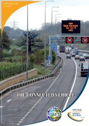
2.5. Roadside Messages<br />
Roadside Messages (DMS). Roadside messages consist of dynamic message signs (DMS), also<br />
known as variable message signs (VMS) that display information <strong>to</strong> travelers while they are<br />
driving. DMS devices provide overhead or side-of-roadway warning, regulation, routing and<br />
management information. These technologies are intended <strong>to</strong> affect the behavior of drivers by<br />
providing real-time traffic information related <strong>to</strong> travel times, incidents, weather, construction, and<br />
special events. DMS are ITS solutions that provide safety and mobility benefits in urban,<br />
ADDITIONAL DESCRIPTION AND QUANTITATIVE BENEFITS OF TRAVEL-TIME RELIABILITY STRATEGIES Page F-4