

Soil Survey of Lincoln County, West Virginia - Soil Data Mart - US ...
Soil Survey of Lincoln County, West Virginia - Soil Data Mart - US ...
Soil Survey of Lincoln County, West Virginia - Soil Data Mart - US ...

You also want an ePaper? Increase the reach of your titles
YUMPU automatically turns print PDFs into web optimized ePapers that Google loves.
<strong>Soil</strong> <strong>Survey</strong> <strong>of</strong> <strong>Lincoln</strong> <strong>County</strong>, <strong>West</strong> <strong>Virginia</strong><br />
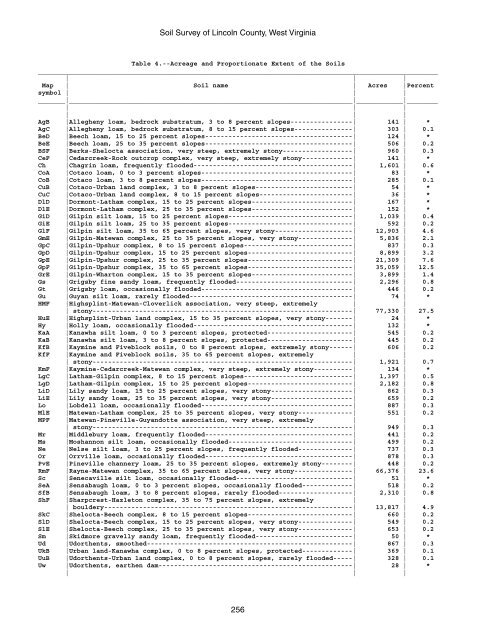
Table 4.--Acreage and Proportionate Extent <strong>of</strong> the <strong>Soil</strong>s<br />
_______________________________________________________________________________________________________<br />
| | |<br />
Map | <strong>Soil</strong> name | Acres |Percent<br />
symbol | | |<br />
_______|_________________________________________________________________________|____________|________<br />
| | |<br />
| | |<br />
AgB |Allegheny loam, bedrock substratum, 3 to 8 percent slopes----------------| 141 | *<br />
AgC |Allegheny loam, bedrock substratum, 8 to 15 percent slopes---------------| 303 | 0.1<br />
BeD |Beech loam, 15 to 25 percent slopes--------------------------------------| 124 | *<br />
BeE |Beech loam, 25 to 35 percent slopes--------------------------------------| 506 | 0.2<br />
BSF |Berks-Shelocta association, very steep, extremely stony------------------| 960 | 0.3<br />
CeF |Cedarcreek-Rock outcrop complex, very steep, extremely stony-------------| 141 | *<br />
Ch |Chagrin loam, frequently flooded-----------------------------------------| 1,601 | 0.6<br />
CoA |Cotaco loam, 0 to 3 percent slopes---------------------------------------| 83 | *<br />
CoB |Cotaco loam, 3 to 8 percent slopes---------------------------------------| 285 | 0.1<br />
CuB |Cotaco-Urban land complex, 3 to 8 percent slopes-------------------------| 54 | *<br />
CuC |Cotaco-Urban land complex, 8 to 15 percent slopes------------------------| 36 | *<br />
DlD |Dormont-Latham complex, 15 to 25 percent slopes--------------------------| 167 | *<br />
DlE |Dormont-Latham complex, 25 to 35 percent slopes--------------------------| 152 | *<br />
GiD |Gilpin silt loam, 15 to 25 percent slopes--------------------------------| 1,039 | 0.4<br />
GiE |Gilpin silt loam, 25 to 35 percent slopes--------------------------------| 592 | 0.2<br />
GlF |Gilpin silt loam, 35 to 65 percent slopes, very stony--------------------| 12,903 | 4.6<br />
GmE |Gilpin-Matewan complex, 25 to 35 percent slopes, very stony--------------| 5,836 | 2.1<br />
GpC |Gilpin-Upshur complex, 8 to 15 percent slopes----------------------------| 837 | 0.3<br />
GpD |Gilpin-Upshur complex, 15 to 25 percent slopes---------------------------| 8,899 | 3.2<br />
GpE |Gilpin-Upshur complex, 25 to 35 percent slopes---------------------------| 21,309 | 7.6<br />
GpF |Gilpin-Upshur complex, 35 to 65 percent slopes---------------------------| 35,059 | 12.5<br />
GrE |Gilpin-Wharton complex, 15 to 35 percent slopes--------------------------| 3,899 | 1.4<br />
Gs |Grigsby fine sandy loam, frequently flooded------------------------------| 2,296 | 0.8<br />
Gt |Grigsby loam, occasionally flooded---------------------------------------| 446 | 0.2<br />
Gu |Guyan silt loam, rarely flooded------------------------------------------| 74 | *<br />
HMF |Highsplint-Matewan-Cloverlick association, very steep, extremely | |<br />
| stony-------------------------------------------------------------------| 77,330 | 27.5<br />
HuE |Highsplint-Urban land complex, 15 to 35 percent slopes, very stony-------| 24 | *<br />
Hy |Holly loam, occasionally flooded-----------------------------------------| 132 | *<br />
KaA |Kanawha silt loam, 0 to 3 percent slopes, protected----------------------| 545 | 0.2<br />
KaB |Kanawha silt loam, 3 to 8 percent slopes, protected----------------------| 445 | 0.2<br />
KfB |Kaymine and Fiveblock soils, 0 to 8 percent slopes, extremely stony------| 606 | 0.2<br />
KfF |Kaymine and Fiveblock soils, 35 to 65 percent slopes, extremely | |<br />
| stony-------------------------------------------------------------------| 1,921 | 0.7<br />
KmF |Kaymine-Cedarcreek-Matewan complex, very steep, extremely stony----------| 134 | *<br />
LgC |Latham-Gilpin complex, 8 to 15 percent slopes----------------------------| 1,397 | 0.5<br />
LgD |Latham-Gilpin complex, 15 to 25 percent slopes---------------------------| 2,182 | 0.8<br />
LiD |Lily sandy loam, 15 to 25 percent slopes, very stony---------------------| 862 | 0.3<br />
LiE |Lily sandy loam, 25 to 35 percent slopes, very stony---------------------| 659 | 0.2<br />
Lo |Lobdell loam, occasionally flooded---------------------------------------| 887 | 0.3<br />
MlE |Matewan-Latham complex, 25 to 35 percent slopes, very stony--------------| 551 | 0.2<br />
MPF |Matewan-Pineville-Guyandotte association, very steep, extremely | |<br />
| stony-------------------------------------------------------------------| 949 | 0.3<br />
Mr |Middlebury loam, frequently flooded--------------------------------------| 441 | 0.2<br />
Ms |Moshannon silt loam, occasionally flooded--------------------------------| 499 | 0.2<br />
Ne |Nelse silt loam, 3 to 25 percent slopes, frequently flooded--------------| 737 | 0.3<br />
Or |Orrville loam, occasionally flooded--------------------------------------| 878 | 0.3<br />
PvE |Pineville channery loam, 25 to 35 percent slopes, extremely stony--------| 448 | 0.2<br />
RmF |Rayne-Matewan complex, 35 to 65 percent slopes, very stony---------------| 66,376 | 23.6<br />
Sc |Senecaville silt loam, occasionally flooded------------------------------| 51 | *<br />
SeA |Sensabaugh loam, 0 to 3 percent slopes, occasionally flooded-------------| 518 | 0.2<br />
SfB |Sensabaugh loam, 3 to 8 percent slopes, rarely flooded-------------------| 2,310 | 0.8<br />
ShF |Sharpcrest-Hazleton complex, 35 to 75 percent slopes, extremely | |<br />
| bouldery----------------------------------------------------------------| 13,817 | 4.9<br />
SkC |Shelocta-Beech complex, 8 to 15 percent slopes---------------------------| 660 | 0.2<br />
SlD |Shelocta-Beech complex, 15 to 25 percent slopes, very stony--------------| 549 | 0.2<br />
SlE |Shelocta-Beech complex, 25 to 35 percent slopes, very stony--------------| 653 | 0.2<br />
Sm |Skidmore gravelly sandy loam, frequently flooded-------------------------| 50 | *<br />
Ud |Udorthents, smoothed-----------------------------------------------------| 867 | 0.3<br />
UkB |Urban land-Kanawha complex, 0 to 8 percent slopes, protected-------------| 369 | 0.1<br />
UuB |Udorthents-Urban land complex, 0 to 8 percent slopes, rarely flooded-----| 328 | 0.1<br />
Uw |Udorthents, earthen dam--------------------------------------------------| 28 | *<br />
| | |<br />
256


