- Page 1 and 2:
An Unexplored Realm in the Heartlan
- Page 3 and 4:
“Note to Reader” The original o
- Page 5 and 6:
Confederacy Model 39 Feudalistic Mo
- Page 7 and 8:
Elemental Analysis of the Soils fro
- Page 9 and 10:
The Initial Occupation of El Marque
- Page 11 and 12:
List of Tables Table 5.1. Ceramic C
- Page 13 and 14:
Figure 3.14. Plan view of the Olmec
- Page 15 and 16:
Figure 5.7. Site map illustrating l
- Page 17 and 18:
Figure 5.53. El Marquesillo throne
- Page 19 and 20:
the resulting data do not fit many
- Page 21 and 22:
Furtherance of my academic career w
- Page 23 and 24:
Introduction Chapter 1. Archaeology
- Page 25 and 26:
esearch being conducted along the S
- Page 27 and 28:
its introduction to Mesoamerican ar
- Page 29 and 30:
participants. It is especially crit
- Page 31 and 32:
interpretations. Finally, I compare
- Page 33 and 34:
analogy (Diehl 1989:25; VanDerwarke
- Page 35 and 36:
change, fluctuates according to “
- Page 37 and 38:
embedded misconceptions about these
- Page 39 and 40:
The “Heartland” has been deline
- Page 41 and 42:
than a century after their occurren
- Page 43 and 44:
inference as opposed to evidence. T
- Page 45 and 46:
Sanders and Webster (1988:544) argu
- Page 47 and 48:
Park (1992:90) presents the Olmec a
- Page 49 and 50:
lowland subsistence economy until a
- Page 51 and 52:
Maya are lineal descendents of the
- Page 53 and 54:
continued to inhibit scientific inq
- Page 55 and 56:
describes this attempted conformanc
- Page 57 and 58:
The models used for evaluation of t
- Page 59 and 60:
number of archaeological correlates
- Page 61 and 62:
Confederacy Model Pool (2000:150;20
- Page 63 and 64:
Limitations and Cautions in the Use
- Page 65 and 66:
Lorenzo is considered the earliest
- Page 67 and 68:
Several lines of evidence suggest a
- Page 69 and 70:
turn, gave budding Olmec leaders co
- Page 71 and 72:
apid growth of settlements and thei
- Page 73 and 74:
techniques (Berger et al. 1967; Hei
- Page 75 and 76:
appear to characterize it as a “c
- Page 77 and 78:
iconographic detail, and appear to
- Page 79 and 80:
Formative period Southern Gulf Lowl
- Page 81 and 82:
Medellín-Zeníl (1960) found large
- Page 83 and 84:
de Agua, and the famous, iconograph
- Page 85 and 86:
egarding subsistence, settlement, p
- Page 87 and 88:
Introduction Chapter 3. El Marquesi
- Page 89 and 90:
300-900). Historical documentation
- Page 91 and 92:
The features of the San Juan are ch
- Page 93 and 94:
Figure 3.4. Aerial photograph of El
- Page 95 and 96:
At each of these three points of co
- Page 97 and 98:
El Marquesillo’s geographic locat
- Page 99 and 100:
of the location for more than 3,500
- Page 101 and 102: The extensive Villa Alta architectu
- Page 103 and 104: of constructions. This formal archi
- Page 105 and 106: To achieve and maintain this elevat
- Page 107 and 108: Figure 3.11. Map of the Southern Gu
- Page 109 and 110: Teotihuacán and Aztec trade routes
- Page 111 and 112: land was not in the form of gold an
- Page 113 and 114: Huaspaltepec (Playa Vicente), betwe
- Page 115 and 116: as listed in these records, include
- Page 117 and 118: community members had to work the l
- Page 119 and 120: The 1944 flood was a momentous even
- Page 121 and 122: of ancient structures, including Ce
- Page 123 and 124: to recover as much information as p
- Page 125 and 126: Figure 3.17. Photograph of El Seño
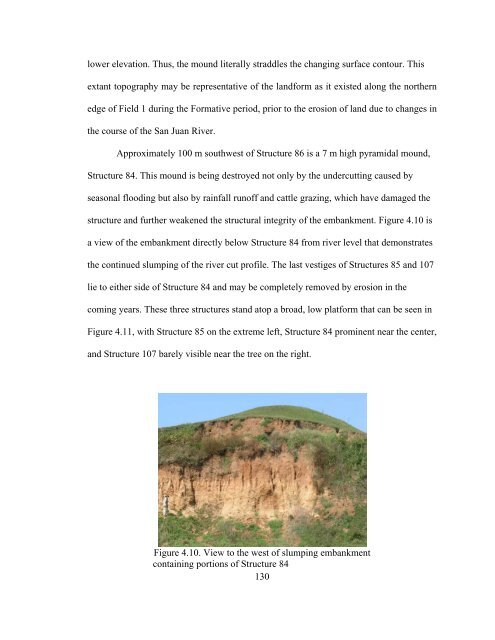
- Page 127 and 128: collection along the cut bank was a
- Page 129 and 130: its termination line (Borstein 2001
- Page 131 and 132: Figure 3.18. Illustration of San Lo
- Page 133 and 134: is seated transitionally between th
- Page 135 and 136: Introduction Chapter 4. El Marquesi
- Page 137 and 138: Grove 1997; Tolstoy 1989). Landscap
- Page 139 and 140: Determination of the Survey Area Th
- Page 141 and 142: Surface Mapping and Terrain Modelin
- Page 143 and 144: Global Positioning System (GPS) Map
- Page 145 and 146: Figure 4.4. Map of El Marquesillo g
- Page 147 and 148: have the potential to record points
- Page 149 and 150: The topographic images and terrain
- Page 151: Figure 4.8. Digital Terrain Model o
- Page 155 and 156: The western third of the platform h
- Page 157 and 158: Figure 4.15. Elevated view of Field
- Page 159 and 160: Figure 4.17. Topographic map of El
- Page 161 and 162: Figure 4.19. Northwest view of spri
- Page 163 and 164: Information Systems (GIS) approach
- Page 165 and 166: Figure 4.21. Illustration of docume
- Page 167 and 168: Magnetic Properties of Basalt The m
- Page 169 and 170: Magnetic Data Collection, Condition
- Page 171 and 172: The magnetometer was set to the bas
- Page 173 and 174: Figure 4.23. Topographical base map
- Page 175 and 176: of basalt, but instead, a body of s
- Page 177 and 178: Figure 4.25. Topographic contour ma
- Page 179 and 180: mercuric sulfide in the soil. There
- Page 181 and 182: Coyote, Honduras (Terry et al. 2000
- Page 183 and 184: intersection on the numbered rows a
- Page 185 and 186: The results were reported in parts
- Page 187 and 188: Figure 4.28b. Box plot summaries of
- Page 189 and 190: Elemental Analysis of the Soils fro
- Page 191 and 192: Summary of the Soil Analyses When t
- Page 193 and 194: Figure 4.31a. Potassium distributio
- Page 195 and 196: estriction prohibiting further exca
- Page 197 and 198: The average depth of any observed a
- Page 199 and 200: Figure 5.7. Site map illustrating l
- Page 201 and 202: Figure 5.8. River cut profile 1A Le
- Page 203 and 204:
Figure 5.9. River cut profile 1B in
- Page 205 and 206:
Figure 5.10. River cut profile 2A L
- Page 207 and 208:
Figure 5.11. River cut profile 6B o
- Page 209 and 210:
Formative to Protoclassic ceramics
- Page 211 and 212:
fabrication methods, technologies,
- Page 213 and 214:
some of the Formative period wares
- Page 215 and 216:
The San Lorenzo Olmec Period (c. 11
- Page 217 and 218:
Figure 5.19. Examples of Middle For
- Page 219 and 220:
The Late Classic Period (c. AD 550-
- Page 221 and 222:
English annular ware (c. AD 1785-18
- Page 223 and 224:
Ceramic Collection Areas The identi
- Page 225 and 226:
Figure 5.26. Distribution of cerami
- Page 227 and 228:
Formative period accounted for 785
- Page 229 and 230:
The survey was conducted along the
- Page 231 and 232:
Figure 5.29. Diagram of Olmec thron
- Page 233 and 234:
Figure 5.30. Map illustrating the l
- Page 235 and 236:
Late Formative (263), Protoclassic
- Page 237 and 238:
demonstrates an analogous situation
- Page 239 and 240:
Offering I Figure 5.32. Locations o
- Page 241 and 242:
Figure 5.34. Offering I is at the c
- Page 243 and 244:
Figure 5.36. Two reconstructed plat
- Page 245 and 246:
crescent with its concave and conve
- Page 247 and 248:
The two figurine types are common t
- Page 249 and 250:
vessels that were deposited into a
- Page 251 and 252:
Figure 5.45. Two of three similar s
- Page 253 and 254:
Obsidian and Lithic Analyses The Ob
- Page 255 and 256:
Throne Units Test Units Offerings I
- Page 257 and 258:
inhabitants from other sites, or in
- Page 259 and 260:
Figure 5.50. Examples of stones tho
- Page 261 and 262:
Figure 5.51. El Marquesillo throne
- Page 263 and 264:
accomplished through violent blows
- Page 265 and 266:
Figure 5.56. Close-up of the figure
- Page 267 and 268:
Figure 5.58. Illustration of magnet
- Page 269 and 270:
Modifications to this pattern occur
- Page 271 and 272:
class occurred only in the presence
- Page 273 and 274:
appearance of ceramics occurred dur
- Page 275 and 276:
series of interrelated residential,
- Page 277 and 278:
The Early Formative period appearan
- Page 279 and 280:
Evidence of these constructions is
- Page 281 and 282:
and the excavated pit is not known,
- Page 283 and 284:
For the Gulf Olmec, monumental exhi
- Page 285 and 286:
precisely. This method would also m
- Page 287 and 288:
An earlier discussion suggested sty
- Page 289 and 290:
approximately 100 cm to 120 cm belo
- Page 291 and 292:
Nevertheless, the structural design
- Page 293 and 294:
discussion about the antiquity of t
- Page 295 and 296:
6.3). At La Venta equivalent basalt
- Page 297 and 298:
shamanistic ritual and rulership (F
- Page 299 and 300:
elevation provides an excellent ove
- Page 301 and 302:
further support to the idea that El
- Page 303 and 304:
Also contributing to the ceramic pr
- Page 305 and 306:
Another possible basalt deposition
- Page 307 and 308:
off is dramatic to say the least. T
- Page 309 and 310:
direction, a series of hills approx
- Page 311 and 312:
Finally, the selection and investig
- Page 313 and 314:
a metaphor for the movements of the
- Page 315 and 316:
plaza complex is also oriented to p
- Page 317 and 318:
the traditional communal ideology.
- Page 319 and 320:
where new diagnostic ceramic types
- Page 321 and 322:
Understanding of the early Postclas
- Page 323 and 324:
ceramics probably arrived at the en
- Page 325 and 326:
investigation before the direction
- Page 327 and 328:
Marquesillo, past and present. Fitt
- Page 329 and 330:
Through the integration of a sequen
- Page 331 and 332:
experienced an upward trend in popu
- Page 333 and 334:
prehispanic occupation would have b
- Page 335 and 336:
Assmann (2006) argues that prehisto
- Page 337 and 338:
1997:288). These changes in residen
- Page 339 and 340:
structures that could provide long-
- Page 341 and 342:
Analysis of these three components
- Page 343 and 344:
Early architectural units, specific
- Page 345 and 346:
activities and that these activitie
- Page 347 and 348:
political structure. Was it an inde
- Page 349 and 350:
subordinate to a nearby primary cen
- Page 351 and 352:
Explanation of Spatial Organization
- Page 353 and 354:
conjunction with other forms of arc
- Page 355 and 356:
Mesoamerican worldviews (Vogt 1981:
- Page 357 and 358:
Expanding the Boundaries and a Look
- Page 359 and 360:
to illustrate their power and wealt
- Page 361 and 362:
emains is striking. This disproport
- Page 363 and 364:
the earliest detectable occupation
- Page 365 and 366:
and Uxpanapa River Basins, I wonder
- Page 367 and 368:
Arnaiz-Villena, A., G. Vargas-Alarc
- Page 369 and 370:
Bassie, K. 2006 The Fire and Water
- Page 371 and 372:
Blake, M. and J. E. Clark 1999 The
- Page 373 and 374:
Butler, R. F. 1992 Paleomagnetism:
- Page 375 and 376:
2001 Gulf Lowlands: South Region. I
- Page 377 and 378:
Coe, M. D., D. Snow and E. Benson 1
- Page 379 and 380:
2003 Laguna de los Cerros: Una Capi
- Page 381 and 382:
2003 Analysis of Formative Period O
- Page 383 and 384:
Elachi, C. 1987 Introduction to the
- Page 385 and 386:
Foster, G. M. 1940 Notes on the Pop
- Page 387 and 388:
2001 La Venta, Tabasco, Mexico. In
- Page 389 and 390:
Halbwachs, M. 1992 On Collective Me
- Page 391 and 392:
Hester, T. R., H. J. Shafer and K.
- Page 393 and 394:
Johnston, K. J. and N. Gonlin 1998
- Page 395 and 396:
Kruger, R. P. 1996 An Archaeologica
- Page 397 and 398:
Madry, S. L. H. 1987 A Multiscalar
- Page 399 and 400:
Middleton, W. D. 2004 Identifying C
- Page 401 and 402:
Ortíz, P. 1975 La Ceramica de los
- Page 403 and 404:
Plog, S. 1990 Agriculture, Sedentis
- Page 405 and 406:
Rapoport, A. 1990 History and Prece
- Page 407 and 408:
Rueda, H. G. 1989 Nuevas Exploracio
- Page 409 and 410:
Santley, R. S., S. A. Nelson, B. K.
- Page 411 and 412:
1989 Olmec Studies: A Status Report
- Page 413 and 414:
Stark, B. L. and P. J. Arnold 1997
- Page 415 and 416:
Tarling, D. H. 1983 Geomagnetism. C
- Page 417 and 418:
Tykot, R. H. 2004 Stable Isotopes a
- Page 419 and 420:
Wallerstein, I. 1974 The Modern Wor
- Page 421 and 422:
2003 The Role of Kinship and Demogr
- Page 423 and 424:
Appendix 1a. Ceramic Analysis: Type
- Page 425 and 426:
Appendix 1b. Ceramic Analysis: Type
- Page 427 and 428:
Appendix 2. Ceramic Types and Count
- Page 429 and 430:
Appendix 2. Ceramic Types and Count
- Page 431 and 432:
Appendix 2. Ceramic Types and Count
- Page 433 and 434:
Appendix 2. Ceramic Types and Count
- Page 435 and 436:
Appendix 2. Ceramic Types and Count
- Page 437 and 438:
Appendix 2. Ceramic Types and Count
- Page 439 and 440:
Appendix 2. Ceramic Types and Count
- Page 441 and 442:
Appendix 2. Ceramic Types and Count
- Page 443 and 444:
Appendix 2. Ceramic Types and Count
- Page 445 and 446:
Appendix 2 Ceramic Types and Counts
- Page 447 and 448:
Appendix 2. Ceramic Types and Count
- Page 449 and 450:
Appendix 2. Ceramic Types and Count
- Page 451 and 452:
Appendix 2. Ceramic Types and Count
- Page 453 and 454:
Appendix 2. Ceramic Types and Count
- Page 455 and 456:
Appendix 2. Ceramic Types and Count
- Page 457 and 458:
Appendix 3a. Obsidian from Test Uni
- Page 459 and 460:
Appendix 3b. Obsidian from Throne E
- Page 461 and 462:
Appendix 4a. Lithics from Surface C
- Page 463 and 464:
Appendix 4b. Lithics from River Cut
- Page 465 and 466:
Appendix 5a. Soil Survey I Element
- Page 467 and 468:
Appendix 5a. Soil Survey I Element
- Page 469 and 470:
Appendix 5b. Soil Survey II Element
- Page 471 and 472:
Appendix 5b. Soil Survey II Element
- Page 473:
About the Author Travis F. Doering