- Page 1 and 2:
Historical SeismogramsandEarthquake
- Page 3:
ToJames F. Landerfor his leadership
- Page 6 and 7:
viContentsThe Status, Importance, a
- Page 8 and 9:
...VlllEarthquake History of Califo
- Page 10 and 11:
XMicrofilming of Historical Seismog
- Page 13 and 14:
PrefaceA symposium on Historical Se
- Page 15:
I. Introduction
- Page 18 and 19:
4 W. H. K. Lee, H. Meyers, and K. S
- Page 20 and 21:
6 W. H. K. Lee, H. Meyers, and K. S
- Page 22 and 23:
8 W. H. h‘. Lee, H. Meyers, and K
- Page 24 and 25:
10 W. H. K. Lee, IT. Meyers, and K.
- Page 26 and 27:
12 W. H. K. Lee, H. Meyers, and K.
- Page 28 and 29:
14 W. H. K. Lee, H. Meyers, and K.
- Page 30 and 31:
IMPORTANCE OF HISTORICAL SEISMOGRAM
- Page 32 and 33:
18 Hiroo KanamoriTable Ib. Some Lar
- Page 34 and 35:
-60'1 1904-1985-M, >8.01II\I'.iPlus
- Page 36 and 37:
22 Hiroo Kanamorievents often have
- Page 38 and 39:
~~~24 Hiroo KanamoriThatcher et al.
- Page 40 and 41:
26 Hiroo Kanamo riIf relatively com
- Page 42 and 43:
28 Hiroo Kanamori9. Difficulties in
- Page 44 and 45:
30 Hiroo KanamoriNagamune, T. (1971
- Page 46 and 47:
32 Hiroo KanamoriI I I I I1000100z
- Page 49:
11. Analysis of Historical Seismogr
- Page 52:
38 Kat su y uki A beaddition to thi
- Page 56 and 57:
42 Katsuyuki Abe20:oow19:302-I--Ia
- Page 58 and 59:
44 Katsuyuki AbeIn the present stud
- Page 60 and 61:
46 Katsuyuki AbeTable 3. Sinkiang E
- Page 62 and 63:
~48 Katsuyuki AbeSieh (1978) and ot
- Page 64 and 65:
50 Katsuyuki AbeREFERENCESAbe, K. (
- Page 66 and 67:
52 E. Hurtig and G. KowalleFRG'.L.-
- Page 68 and 69:
54 E. Hurtig and G. Kowalle2.2 Reco
- Page 70 and 71:
56 E. Hurtig and G. KowalleREFERENC
- Page 72 and 73:
58 N. V. Kondorskaya and Yu. F. Kop
- Page 74 and 75:
60 N. V. Kondorskaya and Yu. F. Kop
- Page 76 and 77:
62 N. V. Kondorskaya and Yu. F. Kop
- Page 78 and 79:
THE STATUS, IMPORTANCE, AND USE OFH
- Page 80 and 81:
66 Ota Kulhdnek1 8 35lo. r 1s ' 20
- Page 82 and 83:
68 Ota Kulhdnek1 UPP EW SEP 9 1954
- Page 84 and 85:
ANALYSIS OF HISTORICAL SEISMOGRAMS
- Page 86 and 87:
72 S. K. Singhfrom Uppsala. We also
- Page 88 and 89:
74S. K. SinghN1 1Oaxaca-X .-x x- x
- Page 90 and 91:
76S. K. SinghESKUPPWIECHERT ELPZ A-
- Page 92 and 93:
78 S. K. SinghJdFJ-22 Feb 1943Ms=7.
- Page 94 and 95:
80 S. K. SinghDE BlLT (DBN) Z$I = 3
- Page 96 and 97:
82 S. K. Singh7. The Great Jalisco,
- Page 98 and 99:
84 S. K. SinghREFERENCESAbe, K. (19
- Page 100 and 101:
86 S. Stein, E. A. Okal and D. A. W
- Page 102 and 103:
88 S. Stein, E. A. Okal and D. A. W
- Page 104 and 105:
90 S. Stein, E. A. Okal and D. A. W
- Page 106 and 107:
92 S. Stein, E. A. Okal and D. A. W
- Page 108 and 109:
94S. Stein, E. A. Okal and D. A. Wi
- Page 110 and 111:
96S. Stein, E. A. Okal and D. A. Wi
- Page 112 and 113:
98 S. Stein, E. A. Okal and D. A. W
- Page 114 and 115:
100 S. Stein, E. A. Okal and D. A.
- Page 116 and 117:
102 S. Stein, E. A. Okal and D. A.
- Page 118 and 119:
104 S. Stein, E. A. Okal and D. A.
- Page 121 and 122:
RECENT ACTIVITIES AT THE INTERNATIO
- Page 123 and 124:
S.S. Felt and Damaging EarthquakesI
- Page 125 and 126:
In t e r na tio n a1 Se is mo logic
- Page 127 and 128:
1. IntroductionCatalogue of Chinese
- Page 129 and 130:
Catalogue of Chinese Earthquakes (M
- Page 131 and 132:
Catalogue of Chinese Earthquakes (M
- Page 133 and 134:
Catalogue of Chinese Earthquakes (M
- Page 135 and 136:
Catalogue of Chinese Earthquakes (A
- Page 137 and 138:
Catalogue of Chinese Earthquakes (M
- Page 139 and 140:
Catalogue of Chinese Earthquakes (A
- Page 141 and 142:
Catalogue of Chinese Earthquakes (M
- Page 143 and 144:
Catalogue of Chinese Earthquakes (M
- Page 145 and 146:
DATA BASES ON HISTORICAL SEISMICITY
- Page 147 and 148:
Data Bases on Historical Seismicity
- Page 149 and 150:
Data Bases on Historical Seismicity
- Page 151 and 152:
Data Bases on Historical Seismicity
- Page 153 and 154:
COMPILATION AND PROCESSING OF HISTO
- Page 155 and 156:
Compilation and Processing of Histo
- Page 157 and 158:
The U. S. Geological Survey’s Dat
- Page 159 and 160:
The U. S. Geological Survey's Datab
- Page 161 and 162:
~ ~The U. 5‘. Geological Survey
- Page 163 and 164:
The U. S. Geological Survey’s Dat
- Page 165 and 166:
Catalog of Large and Damaging Earth
- Page 167 and 168:
YCatalog of Large and Damaging Eart
- Page 169 and 170:
Catalog of Large and Damaging Earth
- Page 171 and 172:
YM D h m1918 2 9 20 461918 2 13 6 7
- Page 173 and 174:
Catalog of Large and Damaging Earth
- Page 175 and 176:
Catalog of Large and Damaging Earth
- Page 177 and 178:
His to ric al Mate ria Is of Chine
- Page 179 and 180:
Historic a1 Mate rials of Chinese E
- Page 181 and 182:
Historical Materials of Chinere Ear
- Page 183 and 184:
His t o r ical Mate rials of Chin e
- Page 185:
IV. Individual Historical Earthquak
- Page 188 and 189:
174 N. N. Ambraseys and C. F. Finke
- Page 190 and 191:
176 N. N. Ambraseys and C. F. Finke
- Page 192 and 193:
178 N. N. Ambraseys and C. F. Finke
- Page 194 and 195:
180 N. N. Ambraseys and C. F. Finke
- Page 196 and 197:
182 N. N. Arnbraseys and C. P. Melv
- Page 198 and 199:
184 N. N. Ambraseys and C. P. Melvi
- Page 200 and 201:
180 N. N. Ambraseys and C. P. Melvi
- Page 202 and 203:
188 N. N. Arnbraseys and C. P. Melv
- Page 204 and 205:
190 N. N. Ambraseys and C. P. Melvi
- Page 206 and 207:
192 N. N. Ambraseys and C. P. Melvi
- Page 208 and 209:
194 N. N. Ambraseys and C. P. Melvi
- Page 210 and 211:
196 N. N. Ambraseys and C. P. Melvi
- Page 212 and 213:
198 N. N. Ambraseys and C. P. Melvi
- Page 214 and 215:
200 N. N. Ambraseys and C. P. Melvi
- Page 216 and 217:
202G. E. Fiedler B.FI1 IFigure 1. T
- Page 218 and 219:
204 G. E. Fiedler B.Figure 3. The S
- Page 220 and 221:
206 G. E. Fiedler B.Origin time Epi
- Page 222 and 223:
EVALUATION OF DAMAGE AND SOURCE PAR
- Page 224 and 225:
2 10 D. Muiioz and A. Udias3. Evalu
- Page 226 and 227:
212 D. Muiioz and A. Udias3 wFigure
- Page 228 and 229:
2 14 D. Mun"oz and A. Udiasgiven by
- Page 230 and 231:
216 D. Muioz and A. UdiasTable 2. D
- Page 232 and 233:
218 D. Munot and A. UdiasGentil, P.
- Page 234 and 235:
220 D. Muiioz and A. UdiasArchivo M
- Page 237:
V. Earthquake History
- Page 240 and 241:
226 M. DeBecker and T. CamelbeeckAt
- Page 242 and 243:
~~228 M. DeBecker and T. Camelbeeck
- Page 244 and 245:
230 M. DeBecker and T. Camelbeeek10
- Page 246 and 247:
DOCUMENTING NEW ZEALAND EARTHQUAKES
- Page 248 and 249:
234 G. A. EabyFrom a seismic point
- Page 250 and 251:
236 G. A. EibyImmediate practical p
- Page 252 and 253:
238 G. A. Eibynorth-west; but subsi
- Page 254 and 255:
240 G. A. Eibywith near-earthquake
- Page 256 and 257:
242 Pao Hua Lee120 121 122 123Figur
- Page 258 and 259:
0.3244 Pao Hua Lee(3) Ryukyu-Taiwan
- Page 260 and 261:
Pa0 Hua LeeTable 2. Major Earthquak
- Page 262 and 263:
248 Pao Hua LeeTable 2. (Continued
- Page 264 and 265:
250 Pao Hua Lee‘. . . an earthqua
- Page 266 and 267:
252 Pao Hua LeeREFERENCESCentral We
- Page 268 and 269:
254 S. Prac h ua b21I151 O0IFigure
- Page 270 and 271:
256 S. PrachuabTable 1. 12 Seismic
- Page 272 and 273:
258 S. Prac h u a bTable 2. (Contin
- Page 274 and 275:
260S. Prachuab94" 96" 98" 1 ooo2ac2
- Page 276 and 277:
262 S. Prachuab.17 MAY 1955EMrliCUA
- Page 278 and 279:
:;13264 S. Prachuab0 .me.0 . .eeee0
- Page 280 and 281:
266 S. Prac hua b005 6 7MAGNITUDEFi
- Page 282 and 283:
268 T. R. Toppozada, C. R. Real, an
- Page 284 and 285:
270 T. R. Toppozada, C. R. Real, an
- Page 286 and 287:
2 72 T. R. Toppozada, C. R. Real, a
- Page 288 and 289:
274 T. R. Toppozada, C. R. Real, an
- Page 290 and 291:
STUDY OF HISTORICAL EARTHQUAKES IN
- Page 292 and 293:
278 Tatsuo Usarni(3) Documents publ
- Page 294 and 295:
280 Tatsuo Usarnin5nlob0D KyotoKama
- Page 296 and 297:
282 Tatsuo Usami:.:.., ........ L,/
- Page 298 and 299:
284 Tatsuo Usami(2) A tsunami attac
- Page 300 and 301:
286 Tatsuo Usami1897lntenrLFigure 6
- Page 302 and 303:
~ ~~~~288 Tatsuo UsamiTable 4. Occu
- Page 304 and 305:
290 R. G. Valenzuela and L. C. Garc
- Page 306 and 307:
n09n08n001NoZlNobIn091n081N 002
- Page 308 and 309:
~ ~~294 R. G. Valenzuela and L. C.
- Page 310 and 311:
296 R. G. Valenzuela and L. C. Garc
- Page 312 and 313:
298 R. Muir Wood, G. Woo, and H. Bu
- Page 314 and 315: 300 R. Muir Wood, G. Woo, and H. Bu
- Page 316 and 317: 302 R. Muir Wood, G. Woo, and H. Bu
- Page 318 and 319: 304 R. Muir Wood, G. Woo, and H. Bu
- Page 320 and 321: 306 R. Muir Wood, G. Woo, and H. Bu
- Page 323 and 324: MAGNITUDE-FAULT LENGTH RELATIONSHIP
- Page 325 and 326: APPLICATIONS OF FUZZY MATHEMATICSIN
- Page 327 and 328: Applications of Fuzzy Mathematics 3
- Page 329 and 330: Applications of Fuzzy Mathematics 3
- Page 331 and 332: Applications of Fuzzy Mathematics 3
- Page 333 and 334: Applications of Fuzzy hluthematics
- Page 335 and 336: ON THE SEISMICITY OF THE MIDDLEASTS
- Page 337 and 338: uca,m a,kma,.IY kfi30 uhd
- Page 339 and 340: On the Seismicity of the Middle Eas
- Page 341 and 342: On the Seismicity of the Middle Eas
- Page 343 and 344: On the Seismicity of the Middle Eas
- Page 345 and 346: On the Seismicity of the Middle Eas
- Page 347 and 348: On the Seismicity oj the Middle Eas
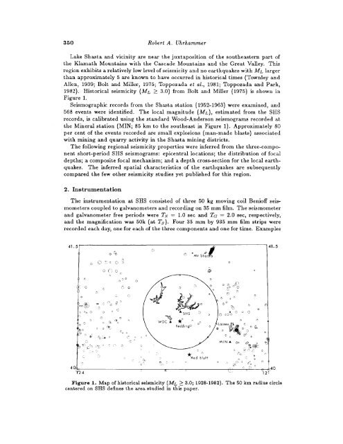
- Page 349 and 350: HISTORICAL SEISMICITY AND EARTHQUAK
- Page 351 and 352: Historical Seismic it y and Earthqu
- Page 353 and 354: fIistorica1 Seismicity and Earthquu
- Page 355 and 356: Historical Seismicity and Earthquak
- Page 357 and 358: Historical Seismicity and Earthquak
- Page 359 and 360: Historical Seismicity and Earthquak
- Page 361 and 362: Historical Seismicity and Earthquak
- Page 363: PATTERN ANALYSIS OF SMALL EARTHQUAK
- Page 367 and 368: Pattern Analysis of Small Earthquak
- Page 369 and 370: Pattern Analysis of Small Earthquak
- Page 371 and 372: Pattern Analysis of Small Earthquak
- Page 373 and 374: Pattern Analysis of Small Earthquak
- Page 375 and 376: Pattern Analysis of Small Earthquak
- Page 377 and 378: Earthquakes and Deep Fracture Zones
- Page 379 and 380: --_-Earthquakes and Deep Fracture Z
- Page 381 and 382: Earthquakes and Deep Fracture Zones
- Page 383: Earthquakes and Deep Fracture Zones
- Page 387 and 388: HISTORICAL SEISMOGRAM FILMING PROJE
- Page 389 and 390: ~~Historical Seismogram Filming Pro
- Page 391 and 392: Historical Seismogram Filming Proje
- Page 393 and 394: Historical Seismogram Filming Proje
- Page 395 and 396: Filming Seismograms and Related Mat
- Page 397 and 398: Filming Seismograms and Related Mat
- Page 399 and 400: Filming Seismograms and Related Mat
- Page 401 and 402: Filming Seismograms and Related Mat
- Page 403 and 404: Filming Seismograms and Related Mat
- Page 405 and 406: Digitization and Processing of J.M.
- Page 407 and 408: Digitization and Processing of J.M.
- Page 409 and 410: Digitization and Processing of J.M.
- Page 411 and 412: Digitization and Processing of J.M.
- Page 413 and 414: Digitization and Processing of J.M.
- Page 415 and 416:
SOME REMARKS ON HISTORICAL SEISMOGR
- Page 417 and 418:
Historical Seismograms and the Micr
- Page 419 and 420:
Historical Seismograms and the Micr
- Page 421 and 422:
~~~~Historical Seismograms and the
- Page 423 and 424:
Historical Seismograms and the Micr
- Page 425 and 426:
His torical Se is mogru ms and the
- Page 427 and 428:
Historical Sezs mogra ms and the Ma
- Page 429 and 430:
H1s t o rical Seismograms a nd the
- Page 431 and 432:
Historical Seismograms and the Micr
- Page 433 and 434:
Historical Seismograms and the Micr
- Page 435:
Historical Seismograms in China 42
- Page 438:
424 Kezin Qua History of Chinese Se
- Page 442 and 443:
428 Kexin Qu8. Plans for the Near F
- Page 444 and 445:
430 0. Ye. Starovoita station, its
- Page 446 and 447:
DAT ANDTHE STANDARDIZATION OF SEISM
- Page 448 and 449:
434 Y. Tamura, H. Sasaki, M. Ooe, a
- Page 450 and 451:
~ So.i436 Y. Tarnura, H. Sasaki, M.
- Page 452 and 453:
438 Y. Tarnura, H. Sasaki, M. Ooe,
- Page 454 and 455:
440 Yasuhiro Umeda and Katsuyoshi I
- Page 456:
442 Yasuhiro Umeda and Katsuyoshi I
- Page 461 and 462:
HISTORICAL SEISMOGRAMS IN ITALYR. C
- Page 463 and 464:
Historical Seismograms in Italy 449
- Page 465 and 466:
HISTORICAL SEISMOGRAMS FROM AUSTRAL
- Page 467 and 468:
His to rical Se is mog ra ms From A
- Page 469 and 470:
SEISMOGRAMS MADE BEFORE 1963 AT STA
- Page 471 and 472:
2. New ZealandSeismograms Before 19
- Page 473 and 474:
Seismograms Before 1963 in the Sout
- Page 475 and 476:
Seismograms Before 1963 in the Sout
- Page 477 and 478:
Historical Seismograms Recorded in
- Page 479 and 480:
Hist orieal Se is mograms Reeo rded
- Page 481 and 482:
THE HISTORICAL SEISMOGRAMS OF COLOM
- Page 483 and 484:
The Historical Seismograms of Colom
- Page 485 and 486:
The Historical Seismograms of Colom
- Page 487 and 488:
The Historical Seismograms of Colom
- Page 489 and 490:
Helwan Historical Seismograms 475Al
- Page 491 and 492:
Se is mo log ic a1 Mea s use me n t
- Page 493 and 494:
Seismological Measurement an Hong K
- Page 495 and 496:
A BRIEF HISTORY OF THE SEISMOLOGICA
- Page 497 and 498:
History of the Seismological Observ
- Page 499 and 500:
History of the Seismological Observ
- Page 501 and 502:
History of the Seismological Observ
- Page 503 and 504:
History of the Seismological Observ
- Page 505:
~~ ~ ~ ~~ ~ ~~Historical Seismogram
- Page 508 and 509:
494 Sergio S. Su, S. J.Figure S. Se
- Page 510 and 511:
496 Sergao S. Su, S. J.Figure 7. Ce
- Page 512 and 513:
498 K. L. SuendsenDominican Republi
- Page 515 and 516:
INDEXAAbuyama Seismological Observa
- Page 517 and 518:
Index 503China, see also Taiwan466
- Page 519 and 520:
Indez505HIHalin seismograph, 421Haw
- Page 521 and 522:
Index 507Karuizawa, 417Kobe, 117, 1
- Page 523 and 524:
Index 509PPacific Ocean1943 Malpelo
- Page 525 and 526:
Index 511Sri Lanka, Colombo station
- Page 527:
Index 513Wood-Anderson seismographW