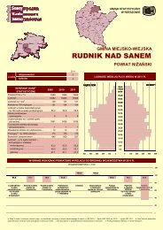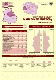
Untitled - Główny Urząd Statystyczny
Untitled - Główny Urząd Statystyczny
Untitled - Główny Urząd Statystyczny

Create successful ePaper yourself
Turn your PDF publications into a flip-book with our unique Google optimized e-Paper software.
DZIAŁ II<br />
STAN I OCHRONA ŚRODOWISKA<br />
Uwagi ogólne<br />
1. Informacje o stanie geodezyjnym i kierunkach<br />
wykorzystania powierzchni województwa ujmowane<br />
są według form władania i grup rejestrowych<br />
w oparciu o ewidencję gruntów wprowadzoną<br />
rozporządzeniem Ministra Rozwoju Regionalnego<br />
i Budownictwa z dnia 29 III 2001 r. w sprawie ewidencji<br />
gruntów i budynków (Dz. U. Nr 38, poz. 454).<br />
Ewidencja ta wprowadziła od 2002 r. zmiany polegające<br />
głównie na włączeniu do użytków rolnych:<br />
gruntów rolnych zabudowanych (poprzednio ujmowanych<br />
w pozycji grunty zabudowane i zurbanizowane),<br />
gruntów pod stawami (ujmowanych<br />
w pozycji wody śródlądowe stojące) oraz rowów<br />
(które stanowiły odrębną pozycję).<br />
Dane o gruntach rolnych i leśnych wyłączonych<br />
na cele nierolnicze i nieleśne dotyczą<br />
gruntów, za które pobrano należności i opłaty<br />
w trybie ustawy z dnia 3 II 1995 r. o ochronie<br />
gruntów rolnych i leśnych (jednolity tekst, Dz. U.<br />
2004 Nr 121, poz. 1266, z późniejszymi zmianami),<br />
która chroni wszystkie grunty rolne zaliczone do<br />
klas bonitacyjnych l-III oraz grunty rolne klas bonitacyjnych<br />
IV-VI wytworzone z gleb organicznych.<br />
Do 2008 r., zgodnie z art. 12 ust. 15 ustawy, rada<br />
gminy mogła podjąć uchwałę o objęciu ochroną na<br />
jej obszarze również gruntów rolnych zaliczonych<br />
do klas bonitacyjnych IV, IVa, IVb wytworzonych<br />
z gleb pochodzenia mineralnego. Od 2009 r. przepisów<br />
ustawy nie stosuje się do gruntów rolnych<br />
stanowiących użytki rolne, położonych w granicach<br />
administracyjnych miast.<br />
Klasy bonitacyjne użytków rolnych określają<br />
jakość użytków rolnych pod względem przydatności<br />
do produkcji rolniczej; klasa l oznacza najwyższą<br />
wartość rolniczą, klasa VI – najniższą. Grunty<br />
przeznaczone pod zalesienia oznaczono symbolami:<br />
orne – RZ; pastwiska – PsZ.<br />
2. Dane o gruntach zdewastowanych i zdegradowanych<br />
wymagających rekultywacji i zagospodarowania<br />
dotyczą gruntów, które utraciły<br />
całkowicie wartości użytkowe (grunty zdewastowane)<br />
oraz gruntów, których wartość użytkowa zmalała<br />
w wyniku pogorszenia się warunków przyrodniczych<br />
lub wskutek zmian środowiska oraz działalności<br />
przemysłowej, a także wadliwej działalności<br />
rolniczej (grunty zdegradowane).<br />
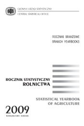
CHAPTER II<br />
ENVIRONMENTAL PROTECTION<br />
General notes<br />
1. Information regarding the geodesic status<br />
and directions in voivodship land use is classified<br />
according to ownership and register groups, of<br />
land included in the land register as a result of the<br />
decree of the Minister of Regional Development<br />
and Construction from 29 III 2001 in regard to the<br />
registration of land and buildings (Journal of Laws<br />
No. 38, item 454).<br />
A land register introduced since 2002 changes<br />
primarily consisting in the inclusion of built-up<br />
agricultural land (which previously was included in<br />
the item “built-up and urbanized land”), land under<br />
ponds (included in the item “standing inland water”)<br />
as well as ditches (which accounted for a separate<br />
item), in agricultural land.<br />
Data regarding agricultural and forest land<br />
designated for non-agricultural and non-forest<br />
purposes concern land, for which payments and<br />
fees were collected, based on the Law on Agricultural<br />
and Forest Land Protection, dated 3 II 1995<br />
(uniform text, Journal of Laws 2004 No. 121, item<br />
1266, with later amendments), which protects all<br />
agricultural land included in quality classes I-III, as<br />
well as agricultural land included in quality classes<br />
IV-VI, comprised of organic soils. Until 2008, in<br />
accordance with Art. 12 item 15 of the Law, a gmina<br />
council might also resolve to protect agricultural<br />
land of IV, IVa, IVb quality classes, originating from<br />
mineral-derived soils and located within the gmina.<br />
Since 2009 the provinsions of the Law do not apply<br />
to agricultural land located within the administrative<br />
borders of urban areas.<br />
Quality classes of agricultural land describe<br />
the quality of land in terms of value to agricultural<br />
production; class I corresponds to the highest<br />
agricultural value and class VI to the lowest. Land<br />
designated for afforestation is given the following<br />
symbols: RZ – for arable land and PsZ – for<br />
pastures.<br />
2. Data regarding devastated and degraded<br />
land requiring reclamation and management<br />
concern land which has completely lost its utility<br />
value (devastated land) and land, the utility value<br />
of which has declined, due to a worsening in natural<br />
conditions or environmental changes and industrial<br />
activity as well as to inappropriate agricultural<br />
practices (degraded land).