

Maarten van Hoek The Geography of Cup-and-Ring ... - StoneWatch
Maarten van Hoek The Geography of Cup-and-Ring ... - StoneWatch
Maarten van Hoek The Geography of Cup-and-Ring ... - StoneWatch

Create successful ePaper yourself
Turn your PDF publications into a flip-book with our unique Google optimized e-Paper software.
Actually they are <strong>of</strong> the average cup-size, but appear to be large<br />
compared to the many really small cupules elsewhere in the valley, some<br />
<strong>of</strong> which have single rings (site 11). <strong>The</strong>re are other figures, such as<br />
“scapulas” <strong>and</strong> a possible idol <strong>and</strong> remarkable is the presence <strong>of</strong> a small<br />
number <strong>of</strong> ‘sun’-symbols, <strong>of</strong>ten consisting <strong>of</strong> an (earlier ?) cup-<strong>and</strong>-tworings<br />
with rays added from its outer ring, the whole enclosed within a<br />
third ring (Fig. 63). <strong>The</strong>se designs may be related to a solar symbol at<br />
Carschenna III (Fig. 68) <strong>and</strong> possibly to the ‘cup-less’ ‘sun’ at Monte<br />
Bego (24). All these solar symbols may be later.<br />
Compared to the <strong>of</strong>ten extremely smooth rock art panels <strong>of</strong> the central<br />
part <strong>of</strong> the valley, Coren de le Fate is really rough <strong>and</strong> motifs have<br />
been carved right across cracks <strong>and</strong> quartz veins. Immediately north <strong>of</strong><br />
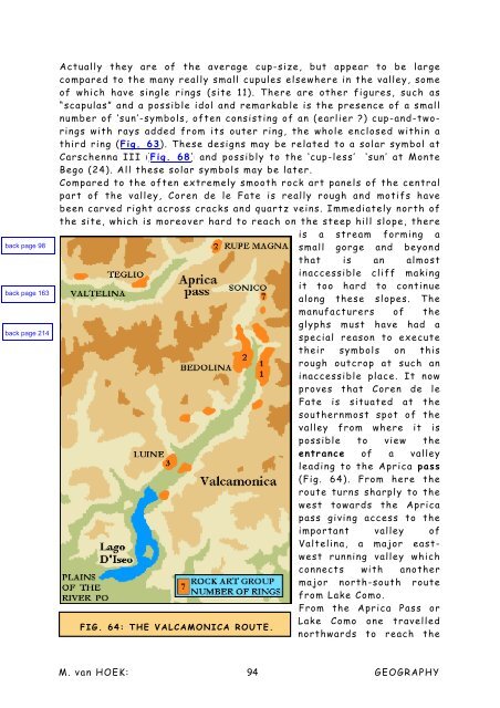
the site, which is moreover hard to reach on the steep hill slope, there<br />
is a stream forming a<br />
small gorge <strong>and</strong> beyond<br />
that is an almost<br />
inaccessible cliff making<br />
it too hard to continue<br />
along these slopes. <strong>The</strong><br />
manufacturers <strong>of</strong> the<br />
glyphs must have had a<br />
special reason to execute<br />
their symbols on this<br />
rough outcrop at such an<br />
inaccessible place. It now<br />
proves that Coren de le<br />
Fate is situated at the<br />
southernmost spot <strong>of</strong> the<br />
valley from where it is<br />
possible to view the<br />
entrance <strong>of</strong> a valley<br />
leading to the Aprica pass<br />
(Fig. 64). From here the<br />
route turns sharply to the<br />
west towards the Aprica<br />
pass giving access to the<br />
important valley <strong>of</strong><br />
Valtelina, a major eastwest<br />
running valley which<br />
connects with another<br />
major north-south route<br />
from Lake Como.<br />
From the Aprica Pass or<br />
Lake Como one travelled<br />
FIG. 64: THE VALCAMONICA ROUTE.<br />
northwards to reach the<br />
M. <strong>van</strong> HOEK: 94<br />
GEOGRAPHY


