

Maarten van Hoek The Geography of Cup-and-Ring ... - StoneWatch
Maarten van Hoek The Geography of Cup-and-Ring ... - StoneWatch
Maarten van Hoek The Geography of Cup-and-Ring ... - StoneWatch

Create successful ePaper yourself
Turn your PDF publications into a flip-book with our unique Google optimized e-Paper software.
� CHAPTER 1.4.2 �<br />
ELVAS AND SPRONS<br />
TWO ALPINE CEREMONIAL CENTRES<br />
* INTRODUCTION *<br />
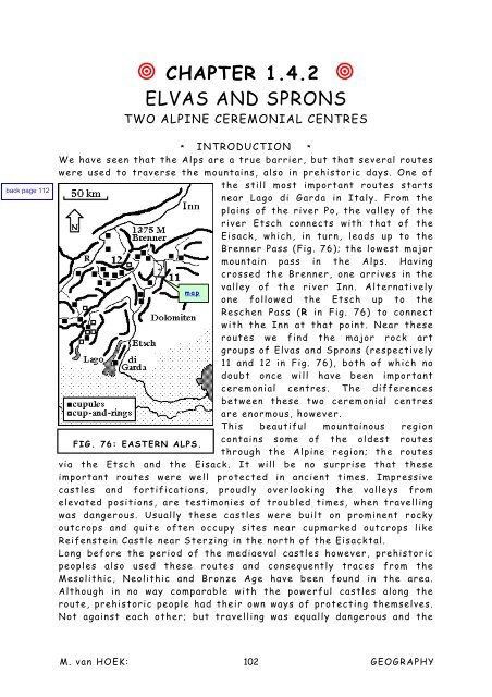
We have seen that the Alps are a true barrier, but that several routes<br />
were used to traverse the mountains, also in prehistoric days. One <strong>of</strong><br />
the still most important routes starts<br />
near Lago di Garda in Italy. From the<br />
plains <strong>of</strong> the river Po, the valley <strong>of</strong> the<br />
river Etsch connects with that <strong>of</strong> the<br />
Eisack, which, in turn, leads up to the<br />
Brenner Pass (Fig. 76); the lowest major<br />
mountain pass in the Alps. Having<br />
crossed the Brenner, one arrives in the<br />
valley <strong>of</strong> the river Inn. Alternatively<br />
map<br />
one followed the Etsch up to the<br />
Reschen Pass (R in Fig. 76) to connect<br />
with the Inn at that point. Near these<br />
routes we find the major rock art<br />
groups <strong>of</strong> Elvas <strong>and</strong> Sprons (respectively<br />
11 <strong>and</strong> 12 in Fig. 76), both <strong>of</strong> which no<br />
doubt once will have been important<br />
ceremonial centres. <strong>The</strong> differences<br />
between these two ceremonial centres<br />
are enormous, however.<br />
This beautiful mountainous region<br />
contains some <strong>of</strong> the oldest routes<br />
FIG. 76: EASTERN ALPS.<br />
through the Alpine region; the routes<br />
via the Etsch <strong>and</strong> the Eisack. It will be no surprise that these<br />
important routes were well protected in ancient times. Impressive<br />
castles <strong>and</strong> fortifications, proudly overlooking the valleys from<br />
elevated positions, are testimonies <strong>of</strong> troubled times, when travelling<br />
was dangerous. Usually these castles were built on prominent rocky<br />
outcrops <strong>and</strong> quite <strong>of</strong>ten occupy sites near cupmarked outcrops like<br />
Reifenstein Castle near Sterzing in the north <strong>of</strong> the Eisacktal.<br />
Long before the period <strong>of</strong> the mediaeval castles however, prehistoric<br />
peoples also used these routes <strong>and</strong> consequently traces from the<br />
Mesolithic, Neolithic <strong>and</strong> Bronze Age have been found in the area.<br />
Although in no way comparable with the powerful castles along the<br />
route, prehistoric people had their own ways <strong>of</strong> protecting themselves.<br />
Not against each other; but travelling was equally dangerous <strong>and</strong> the<br />
M. <strong>van</strong> HOEK: 102<br />
GEOGRAPHY


