- Page 1:
The World of Petroglyphs CD Special
- Page 4 and 5:
Impressum: Stonewatch Society for c
- Page 7 and 8: M. van HOEK: GEOGRAPHY INDEX PART 1
- Page 9 and 10: lifetime job. For instance, it took
- Page 11 and 12: * 1.1.2 THE LIMITS OF THE SUBJECT *
- Page 13 and 14: geomorphologic characteristics of t
- Page 15 and 16: The Irish island has three major op
- Page 17 and 18: � CHAPTER 1.2.1 � THE KILMARTIN
- Page 19 and 20: It is certain that, also in the Kil
- Page 21 and 22: possible site of menhir 8 are surro
- Page 23 and 24: interfered with their observations.
- Page 25 and 26: * 1.2.1.2 PETROGLYPHS AND INTERVISI
- Page 27 and 28: * 1.2.1.2.1.1 The west route initia
- Page 29 and 30: and the possible landing site. View
- Page 31 and 32: photo photo photo FIG. 14: THE EAST
- Page 33 and 34: Achnabreck is a complex of nine wid
- Page 35 and 36: standing stone in Fig. 6) and for t
- Page 37 and 38: The situation in the study area dif
- Page 39 and 40: art sites in the study area (and el
- Page 41 and 42: major route through the interior, a
- Page 43 and 44: * 1.2.2.1.3 Still further east anot
- Page 45 and 46: the rock art groups as their ritual
- Page 47 and 48: elatively level land. These groups
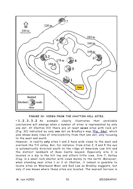
- Page 49 and 50: top of a protruding rock shelter. I
- Page 51 and 52: map map map map map FIG. 26b: BRADL
- Page 53 and 54: impossible that these two sites eve
- Page 55: * 1.2.3.2.5 The group north of Roth
- Page 59 and 60: not mean that this has been intende
- Page 61 and 62: concentrations of stone circles and
- Page 63 and 64: my study area. Their distribution m
- Page 65 and 66: on the coast opposite Muros peninsu
- Page 67 and 68: illus FIGURE 39: PETROGLYPH SITES A
- Page 69 and 70: FIG.42: SANTA TECLA, CASTRO. instan
- Page 71 and 72: small bit of the Taxes valley (mark
- Page 73 and 74: Moreover, from whatever direction t
- Page 75 and 76: argue that all these sites command
- Page 77 and 78: One petroglyph outcrop stone is eve
- Page 79 and 80: � CHAPTER 1.3.2 � GARGAMALA, A
- Page 81 and 82: FIGURE 52: VISIBILITY FROM THE SITE
- Page 83 and 84: encircle the ridge. Also the distri
- Page 85 and 86: idge, centring on sites 3 and 4. Wh
- Page 87 and 88: APPENDIX 1 AN INVENTORY OF THE ROCK
- Page 89 and 90: Group 7C. Described by COSTAS GOBER
- Page 91 and 92: and is approximately 1 to 0.5 cm de
- Page 93 and 94: � CHAPTER 1.4 � THE ALPS, THE B
- Page 95 and 96: * 1.4.1.1.1 There indeed prove to b
- Page 97 and 98: * 1.4.1.1.2 Although the Alps are r
- Page 99 and 100: FIG. 63: PART OF COREN DE LE FATE,
- Page 101 and 102: floodplain of the valley of the Upp
- Page 103 and 104: This rock also features a small cup
- Page 105 and 106: idge called Crete des Barmes, only
- Page 108 and 109:
� CHAPTER 1.4.2 � ELVAS AND SPR
- Page 110 and 111:
photo photo photo photo FIG. 77: TH
- Page 112 and 113:
found linearly grouped along a stee
- Page 114 and 115:
undertaken (Figs 84 and 85). The tr
- Page 116 and 117:
FIGURE 87: SPRONS 2. The lack of ro
- Page 118 and 119:
especially dealing with the distrib
- Page 120 and 121:
In many rock art regions there seem
- Page 122 and 123:
occur in a vast area. Many cupules
- Page 124 and 125:
� CHAPTER 1.5.1 � DISTRIBUTION
- Page 126 and 127:
icecap first caused the land to sin
- Page 128 and 129:
the study area, especially in Swede
- Page 130 and 131:
� CHAPTER 1.5.2 � DISTRIBUTION
- Page 132 and 133:
illus. illus. FIG. 97: ROCK ART DIS
- Page 134 and 135:
islands in bays or in lake systems
- Page 136 and 137:
� CHAPTER 1.5.3 � DISTRIBUTION
- Page 138 and 139:
* 1.5.3.1.1 It is remarkable that r
- Page 140 and 141:
* 1.5.3.2.2 Probably the youngest r
- Page 142 and 143:
* 1.5.3.2.4.1 Almost every part of
- Page 144 and 145:
claiming the rock art at Helgaberg/
- Page 146 and 147:
This notch is also the first natura
- Page 148 and 149:
Another cupuled stone has been repo
- Page 150 and 151:
Swedish distribution moreover echoe
- Page 152 and 153:
APPENDIX 2. Spreadsheet summarising
- Page 154 and 155:
APPENDIX 4. A HORDALAND (Area 2) 37
- Page 156 and 157:
APPENDIX 6 There is always a proble
- Page 159 and 160:
� CHAPTER 2.1 � DISTRIBUTION OF
- Page 161 and 162:
centripetal pull. Not only impressi
- Page 163 and 164:
* 2.1.1 THE ALPINE SITUATION * We a
- Page 165 and 166:
* 2.1.2 THE BRITISH ISLES * Contrar
- Page 167 and 168:
FIGURE 129. BALLOCHMYLE. THIS IS A
- Page 169 and 170:
* 2.1.3 GALICIA * Unfortunately, th
- Page 171 and 172:
The distribution in south Sweden is
- Page 173 and 174:
� CHAPTER 2.2 � INSTANCES OF
- Page 175 and 176:
G stops at motif D. This proves tha
- Page 177 and 178:
example occurs at Gargamala 7J, Gal
- Page 179 and 180:
“....but 3 is special. It is one
- Page 181 and 182:
ILLUS FIGURE 140: ROCK ART ON TOP O
- Page 183 and 184:
* 2.2.1.1.3 GREENLAND * Unfortunate
- Page 185 and 186:
In my opinion, the Greenland raft o
- Page 187 and 188:
FOSSUM VITLYCKE HERREBRO LÖKEBERG
- Page 189 and 190:
on the same panel as the boat figur
- Page 191 and 192:
Equally, cup-and-rings sometimes ha
- Page 193 and 194:
Could this be an indication of a ma
- Page 195 and 196:
Such human figures have been labell
- Page 197 and 198:
earlier rosette figures and the cup
- Page 199 and 200:
FIGURE 155: FINNTORP, PHASES OF ENG
- Page 201 and 202:
solar symbolism as well. Later in t
- Page 203 and 204:
� CHAPTER 2.2.4 � GALICIA: THE
- Page 205 and 206:
animals, probably because of lack o
- Page 207 and 208:
The fact that this is not the case,
- Page 209 and 210:
FIGURE 161: OS CARBALLOS. M. van HO
- Page 211 and 212:
� SCANDINAVIAN SOLAR ANIMALS �
- Page 213 and 214:
of the two smaller animals at Lombo
- Page 215 and 216:
For the rest, combinations of cup-a
- Page 217 and 218:
place in rather peaceful cultures,
- Page 219 and 220:
A B� FIG. 174: A: RI CRUIN CIST;
- Page 221 and 222:
If indeed this engraving is a true
- Page 223 and 224:
other sites known to depict weaponr
- Page 225 and 226:
Illapel and La Silla belong to the
- Page 227 and 228:
* 3.1.3 COMPLEX MOTIFS * From the a
- Page 229 and 230:
� 3.2 THE CUP-AND-RING IN EUROPE
- Page 231 and 232:
The best way to achieve and maintai
- Page 233 and 234:
executed. This may explain why the
- Page 235 and 236:
and it seems that cup-and-ring site
- Page 237 and 238:
* 3.2.3 ENTRANCES TO THE SPIRIT WOR
- Page 239 and 240:
suggested that cupules symbolise th
- Page 241 and 242:
* 3.2.5 THE SIGNIFICANCE OF CUPULES
- Page 243 and 244:
These migrations and explorations c
- Page 245 and 246:
andomly placed on the rocks, were e
- Page 247 and 248:
Later in the Neolithic more revolut
- Page 249 and 250:
The section below serves to acknowl
- Page 251 and 252:
14. BEDNARIK, R. G. 1996. Early roc
- Page 253 and 254:
39. COSTAS GOBERNA, F. J., NOVOA Á
- Page 255 and 256:
63. MARK, R. & NEWMAN, E. 1995. Cup
- Page 257 and 258:
88. PETTERSSON, J. & G. KRISTIANSSO
- Page 259 and 260:
113. VAN HOEK, M. 1988b. Possible
- Page 261:
137. VAN HOEK, M. & SMITH, C. 1988.