

Maarten van Hoek The Geography of Cup-and-Ring ... - StoneWatch
Maarten van Hoek The Geography of Cup-and-Ring ... - StoneWatch
Maarten van Hoek The Geography of Cup-and-Ring ... - StoneWatch

You also want an ePaper? Increase the reach of your titles
YUMPU automatically turns print PDFs into web optimized ePapers that Google loves.
floodplain <strong>of</strong> the valley <strong>of</strong> the Upper Rhine near Carschenna via either<br />
Tinizong <strong>and</strong> the Albula gorge or the Via Mala. Having reached the<br />
Rhine at Carschenna one knew that the strenuous crossing <strong>of</strong> the Alps<br />
was done <strong>and</strong> that more easy travelling via wide valley floors was ahead.<br />
At Mels <strong>and</strong> Sevelen (13 <strong>and</strong> 14 on Fig. 58) one finds the last simple<br />
cup-<strong>and</strong>-ring sites on one <strong>of</strong> the longest routes through the Alps.<br />
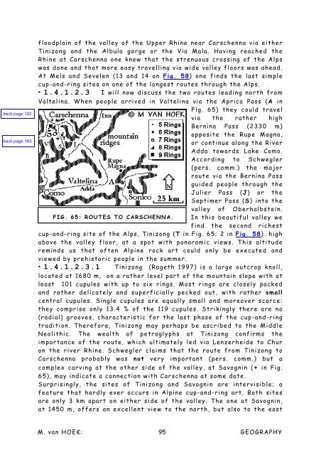
* 1.4.1.2.3 I will now discuss the two routes leading north from<br />
Valtelina. When people arrived in Valtelina via the Aprica Pass (A in<br />
Fig. 65) they could travel<br />
via the rather high<br />
Bernina Pass (2330 m)<br />
opposite the Rupe Magna,<br />
or continue along the River<br />
Adda towards Lake Como.<br />
According to Schwegler<br />
(pers. comm.) the major<br />
route via the Bernina Pass<br />
guided people through the<br />
Julier Pass (J) or the<br />
Septimer Pass (S) into the<br />
valley <strong>of</strong> Oberhalbstein.<br />
FIG. 65: ROUTES TO CARSCHENNA. In this beautiful valley we<br />
find the second richest<br />
cup-<strong>and</strong>-ring site <strong>of</strong> the Alps, Tinizong (T in Fig. 65; 2 in Fig. 58), high<br />
above the valley floor, at a spot with panoramic views. This altitude<br />
reminds us that <strong>of</strong>ten Alpine rock art could only be executed <strong>and</strong><br />
viewed by prehistoric people in the summer.<br />
* 1.4.1.2.3.1 Tinizong (Rageth 1997) is a large outcrop knoll,<br />
located at 1680 m, on a rather level part <strong>of</strong> the mountain slope with at<br />
least 101 cupules with up to six rings. Most rings are closely packed<br />
<strong>and</strong> rather delicately <strong>and</strong> superficially pecked out, with rather small<br />
central cupules. Single cupules are equally small <strong>and</strong> moreover scarce:<br />
they comprise only 13.4 % <strong>of</strong> the 119 cupules. Strikingly there are no<br />
(radial) grooves, characteristic for the last phase <strong>of</strong> the cup-<strong>and</strong>-ring<br />
tradition. <strong>The</strong>refore, Tinizong may perhaps be ascribed to the Middle<br />
Neolithic. <strong>The</strong> wealth <strong>of</strong> petroglyphs at Tinizong confirms the<br />
importance <strong>of</strong> the route, which ultimately led via Lenzerheide to Chur<br />
on the river Rhine. Schwegler claims that the route from Tinizong to<br />
Carschenna probably was not very important (pers. comm.) but a<br />
complex carving at the other side <strong>of</strong> the valley, at Savognin (+ in Fig.<br />
65), may indicate a connection with Carschenna at some date.<br />
Surprisingly, the sites <strong>of</strong> Tinizong <strong>and</strong> Savognin are intervisible; a<br />
feature that hardly ever occurs in Alpine cup-<strong>and</strong>-ring art. Both sites<br />
are only 3 km apart on either side <strong>of</strong> the valley. <strong>The</strong> one at Savognin,<br />
at 1450 m, <strong>of</strong>fers an excellent view to the north, but also to the east<br />
M. <strong>van</strong> HOEK: 95<br />
GEOGRAPHY


