

Maarten van Hoek The Geography of Cup-and-Ring ... - StoneWatch
Maarten van Hoek The Geography of Cup-and-Ring ... - StoneWatch
Maarten van Hoek The Geography of Cup-and-Ring ... - StoneWatch

You also want an ePaper? Increase the reach of your titles
YUMPU automatically turns print PDFs into web optimized ePapers that Google loves.
illus<br />
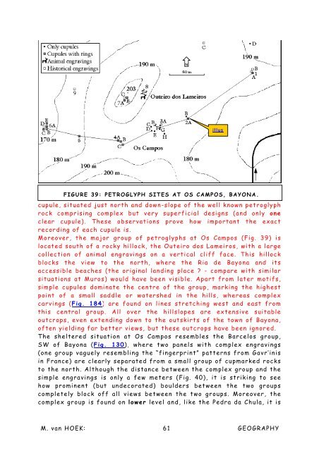
FIGURE 39: PETROGLYPH SITES AT OS CAMPOS, BAYONA.<br />
cupule, situated just north <strong>and</strong> down-slope <strong>of</strong> the well known petroglyph<br />
rock comprising complex but very superficial designs (<strong>and</strong> only one<br />
clear cupule). <strong>The</strong>se observations prove how important the exact<br />
recording <strong>of</strong> each cupule is.<br />
Moreover, the major group <strong>of</strong> petroglyphs at Os Campos (Fig. 39) is<br />
located south <strong>of</strong> a rocky hillock, the Outeiro dos Lameiros, with a large<br />
collection <strong>of</strong> animal engravings on a vertical cliff face. This hillock<br />
blocks the view to the north, where the Ria de Bayona <strong>and</strong> its<br />
accessible beaches (the original l<strong>and</strong>ing place ? - compare with similar<br />
situations at Muros) would have been visible. Apart from later motifs,<br />
simple cupules dominate the centre <strong>of</strong> the group, marking the highest<br />
point <strong>of</strong> a small saddle or watershed in the hills, whereas complex<br />
carvings (Fig. 184) are found on lines stretching west <strong>and</strong> east from<br />
this central group. All over the hillslopes are extensive suitable<br />
outcrops, even extending down to the outskirts <strong>of</strong> the town <strong>of</strong> Bayona,<br />
<strong>of</strong>ten yielding far better views, but these outcrops have been ignored.<br />
<strong>The</strong> sheltered situation at Os Campos resembles the Barcelos group,<br />
SW <strong>of</strong> Bayona (Fig. 130), where two panels with complex engravings<br />
(one group vaguely resembling the “fingerprint” patterns from Gavr’inis<br />
in France) are clearly separated from a small group <strong>of</strong> cupmarked rocks<br />
to the north. Although the distance between the complex group <strong>and</strong> the<br />
simple engravings is only a few meters (Fig. 40), it is striking to see<br />
how prominent (but undecorated) boulders between the two groups<br />
completely block <strong>of</strong>f all views between the two groups. Moreover, the<br />
complex group is found on lower level <strong>and</strong>, like the Pedra da Chula, it is<br />
M. <strong>van</strong> HOEK: 61 GEOGRAPHY


