

Maarten van Hoek The Geography of Cup-and-Ring ... - StoneWatch
Maarten van Hoek The Geography of Cup-and-Ring ... - StoneWatch
Maarten van Hoek The Geography of Cup-and-Ring ... - StoneWatch

You also want an ePaper? Increase the reach of your titles
YUMPU automatically turns print PDFs into web optimized ePapers that Google loves.
the relief is steeper <strong>and</strong> the mountains are higher. Moreover, all rock<br />
art sites are found near sweet water; streams emptying into Lake<br />
Stordal <strong>and</strong> the lake itself. None <strong>of</strong> the sites has a view across the<br />
salt water <strong>of</strong> the Åkrafjorden, which, however, is only two kilometres<br />
to the north <strong>of</strong> Lake Stordal.<br />
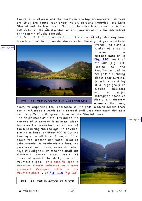
* 1.5.3.3.1 Still, access to <strong>and</strong> from the Åkrafjorden may have<br />
been important to the people who executed the engravings around Lake<br />
Stordal, as quite a<br />
number <strong>of</strong> sites is<br />
focussed on a<br />
distinct pass (P in<br />
Fig. 110) north <strong>of</strong><br />
the lake (Fig. 111),<br />
leading to the<br />
Åkrafjorden <strong>and</strong> to<br />
two possible l<strong>and</strong>ing<br />
places near Kyrping.<br />
Especially the siting<br />
<strong>of</strong> a large group <strong>of</strong><br />
cupuled boulders<br />
<strong>and</strong> a major<br />
petroglyph stone at<br />
Flote, all directly<br />
FIG. 111: THE PASS TO THE ÅKRAFJORDEN.<br />
opposite the pass,<br />
seems to emphasise the importance <strong>of</strong> the pass. Modern access from<br />
the Åkrafjorden towards Lake Stordal still uses this pass: the main<br />
road from Oslo to Haugesund turns to Lake Stordal there.<br />
<strong>The</strong> major stone at Flote is found on the<br />
remains <strong>of</strong> an ancient delta kame, which<br />
indicates the prehistoric water level <strong>of</strong><br />
the lake during the Ice Age. This typical<br />
flat delta kame, at about 100 m OD <strong>and</strong><br />
hanging at an altitude <strong>of</strong> roughly 50 m<br />
above the present day water level <strong>of</strong><br />
Lake Stordal, is easily visible from the<br />
pass mentioned above, especially when<br />
rays <strong>of</strong> sunlight illuminate the small but<br />
distinctly bright green patch <strong>of</strong><br />
grassl<strong>and</strong> amidst the dark, tree clad<br />
mountain slopes. This specific spot is<br />
moreover clearly indicated by a most<br />
prominent V-shaped notch in the<br />
mountain chain (V at Fig. 110; Fig 112).<br />
FIG. 112: THE V-NOTCH AT FLOTE.<br />
M. <strong>van</strong> HOEK: 139<br />
GEOGRAPHY


