

Maarten van Hoek The Geography of Cup-and-Ring ... - StoneWatch
Maarten van Hoek The Geography of Cup-and-Ring ... - StoneWatch
Maarten van Hoek The Geography of Cup-and-Ring ... - StoneWatch

You also want an ePaper? Increase the reach of your titles
YUMPU automatically turns print PDFs into web optimized ePapers that Google loves.
the rock art groups as their ritual centre, but simultaneously as<br />
territorial markers.<br />
* 1.2.2.1.3.2 But there is another discrepancy in this area.<br />
From Fearnan a line <strong>of</strong> simple petroglyph rocks indicates a movement to<br />
the north, but most sites are still found on lower level <strong>and</strong> on both<br />
sides <strong>of</strong> the small valley. At the spot where the route turns east again<br />
(Fig. 20), two cup-<strong>and</strong>-ring rocks at Cr<strong>of</strong>t Garbh overlook that turning<br />
point. It is moreover remarkable that rock art does not exist further<br />
west in Glen Lyon (except for the rock at Camusvrachan). This recalls<br />
the situation at Duncroisk <strong>and</strong> reinforces the idea that the initial<br />
movement was directed to the east. However, the line <strong>of</strong> rock art sites<br />
turned north again via Keltney Burn <strong>and</strong> connected with the valley <strong>of</strong><br />
the river Tummel where a few rock art sites exist. Further north <strong>of</strong><br />
the river Tummel rock art is completely lacking in a very large area.<br />
It is remarkable that, when rock art is still indicating this route, it<br />
remains rather simple <strong>of</strong> character; only cupules <strong>and</strong> a few simple cup<strong>and</strong>-rings<br />
occur. Numbers are also fewer (see Fig. 20 graphs, <strong>and</strong><br />
Appendix 1). This pattern changes when one goes further east.<br />
East <strong>of</strong> Acharn <strong>and</strong> more or less opposite Fearnan a small number <strong>of</strong><br />
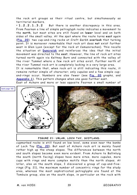
FIGURE 21: URLAR, LOCH TAY, SCOTLAND.<br />
cupmarked rocks is still found on low level, some even near the banks<br />
<strong>of</strong> Loch Tay (Fig. 20). But east <strong>of</strong> Acharn rock art is mainly found<br />
rather high up the steep slopes. <strong>The</strong> differences between the north<br />
<strong>and</strong> south slopes become even more evident. From Acharn to Ballinluig<br />
the south (north facing) slopes have more sites, more cupules, more<br />
cups with rings <strong>and</strong> more complex motifs than the north slopes. At<br />
Urlar, also on the south slope, I discovered a group <strong>of</strong> cup-<strong>and</strong>-fiverings<br />
(Fig. 21), the maximum number <strong>of</strong> concentric rings for the study<br />
area, whereas the most sophisticated petroglyphs are found at the<br />
Tombuie group, also on the south slope, in particular on the rock with<br />
M. <strong>van</strong> HOEK: 39<br />
GEOGRAPHY


