

Maarten van Hoek The Geography of Cup-and-Ring ... - StoneWatch
Maarten van Hoek The Geography of Cup-and-Ring ... - StoneWatch
Maarten van Hoek The Geography of Cup-and-Ring ... - StoneWatch

You also want an ePaper? Increase the reach of your titles
YUMPU automatically turns print PDFs into web optimized ePapers that Google loves.
Further west in Glenlochay, rock art is strikingly absent. More<br />
importantly, the Duncroisk group is concentrated at a point in the<br />
valley where it became clear that the route only would lead further<br />
west, <strong>and</strong> this may indicate that, in my opinion, prehistoric migration<br />
initially was directed to the east (compare Bute).<br />
Simultaneously the major rock art group is located at a spot where a<br />
pass through the mountains leads to the NE, towards Glen Lyon. <strong>The</strong><br />
site at Corrycharmaig overlooks this pass to the north, <strong>and</strong> two sites<br />
near Tullich <strong>and</strong> a st<strong>and</strong>ing stone further north indicate the route.<br />
Exactly where this route ends we find the only cupmarked stone in Glen<br />
Lyon, at Camusvrachan, on a south facing slope, overlooking the same<br />
pass to the south. This hardly can be coincidence.<br />
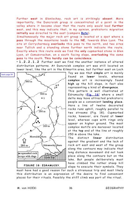
* 1.2.2.1.2 Further east we find the another instance <strong>of</strong> altered<br />
distribution patterns. At Duncroisk complex art was still located on<br />
lower level, like the art in the Kilmartin area, but further east on Loch<br />
Tay we see that simple art is mainly<br />
found on lower levels, whereas<br />
complex art is increasingly found<br />
high up the hill slope, in fact also<br />
representing a kind <strong>of</strong> divergence.<br />
This pattern is well illustrated at<br />
Edramucky (Fig. 16) where a small<br />
delta may have attracted prehistoric<br />
people as a convenient l<strong>and</strong>ing place.<br />
Here a line <strong>of</strong> twelve decorated<br />
rocks runs uphill, roughly parallel to<br />
two streams (Fig. 18). <strong>Cup</strong>marked<br />
rocks, however, are found at lower<br />
level, whereas cups with rings only<br />
appear on higher ground. <strong>The</strong> most<br />
complex motifs are moreover located<br />
at the top end <strong>of</strong> the line at roughly<br />
250 m above the lake.<br />
<strong>The</strong> distinct linear distribution<br />
against the gradient <strong>and</strong> the lack <strong>of</strong><br />
rock art east <strong>and</strong> west <strong>of</strong> the group<br />
along the contours may indicate that<br />
long distance movement did not took<br />
place along the contours but on the<br />
lake. But people deliberately must<br />
have climbed the rather steep hill<br />
FIGURE 18: EDRAMUCKY.<br />
slope to execute their symbols. <strong>The</strong>y<br />
must have had a good reason for such a strenuous trip <strong>and</strong> most likely<br />
this distribution is an expression <strong>of</strong> the desire to find convenient<br />
places for their rituals. Possibly the stiff climb was part <strong>of</strong> the ritual.<br />
M. <strong>van</strong> HOEK: 36<br />
GEOGRAPHY


