

Maarten van Hoek The Geography of Cup-and-Ring ... - StoneWatch
Maarten van Hoek The Geography of Cup-and-Ring ... - StoneWatch
Maarten van Hoek The Geography of Cup-and-Ring ... - StoneWatch

Create successful ePaper yourself
Turn your PDF publications into a flip-book with our unique Google optimized e-Paper software.
ather featureless <strong>and</strong> is dominated by the farther horizon with the<br />
distinct rounded peaks <strong>of</strong> the Cheviot Hills. This is repeated at many<br />
more sites, for instance at Amerside Law Hill, where the rock art sites<br />
are not even located near the escarpment <strong>and</strong> in some instances it is<br />
therefore not possible to see the sites on the lower dip slopes <strong>of</strong><br />
Weetwood Hill <strong>and</strong> Dod Law when st<strong>and</strong>ing at or near these sites on<br />
Amerside Law Hill.<br />
<strong>The</strong> Chatton Hill group also represents the end <strong>of</strong> a line <strong>of</strong> rock art<br />
sites from Bewick Hill. Strikingly, there is no rock art reported north<br />
<strong>of</strong> Chatton Hill, although the s<strong>and</strong>stone ridge continues further north<br />
for at least 10 kilometres, <strong>of</strong>fering equally fine smooth outcrop areas<br />
with views similar to those from Chatton Hill.<br />
* 1.2.3.3.3 In my opinion, the migration came from the south <strong>and</strong><br />
used the valley <strong>of</strong> the river Till for quite a long distance. But one left<br />
this course near Chatton <strong>and</strong> turned to the north-west, towards Hare<br />
Crags <strong>and</strong> Roughting Linn,<br />
via the gentle dip slopes<br />
MAP<br />
<strong>of</strong> the more westerly<br />
s<strong>and</strong>stone ridge <strong>of</strong><br />
Doddington Moor. Rock art<br />
proves to overlook this<br />
route, rather than being<br />
focussed on the Milfield<br />
Basin, as Bradley suggests<br />
(1997: 113). <strong>The</strong>re indeed<br />
are sites that overlook the<br />
these plains, but too few<br />
to base a definite link<br />
with the Milfield Basin<br />
upon.<br />
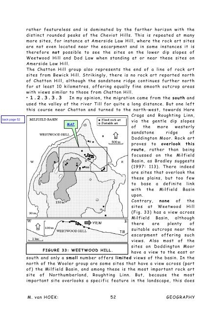
Contrary, none <strong>of</strong> the<br />
sites at Weetwood Hill<br />
(Fig. 33) has a view across<br />
Milfield Basin, although<br />
there are plenty <strong>of</strong><br />
suitable outcrops near the<br />
escarpment <strong>of</strong>fering such<br />
views. Also most <strong>of</strong> the<br />
sites on Doddington Moor<br />
FIGURE 33: WEETWOOD HILL.<br />
have a view to the east or<br />
south <strong>and</strong> only a small number <strong>of</strong>fers limited views <strong>of</strong> the basin. In the<br />
north <strong>of</strong> the Wooler group are some sites that have a view across (part<br />
<strong>of</strong>) the Milfield Basin, <strong>and</strong> among these is the most important rock art<br />
site <strong>of</strong> Northumberl<strong>and</strong>, Roughting Linn. But, because the most<br />
important site overlooks a specific feature in the l<strong>and</strong>scape, this does<br />
M. <strong>van</strong> HOEK: 52 GEOGRAPHY


