

Maarten van Hoek The Geography of Cup-and-Ring ... - StoneWatch
Maarten van Hoek The Geography of Cup-and-Ring ... - StoneWatch
Maarten van Hoek The Geography of Cup-and-Ring ... - StoneWatch

Create successful ePaper yourself
Turn your PDF publications into a flip-book with our unique Google optimized e-Paper software.
impossible that these two sites ever were intervisible. <strong>The</strong> line<br />
between Corby Crags <strong>and</strong> Lemmington Wood is doubtful, but could not<br />
be checked by me because <strong>of</strong> the vegetation. <strong>The</strong> same applies for a<br />
possible line between Lamp Hill <strong>and</strong> Lemmington Wood.<br />
Similarly, the suggested lines from the Caller Crag site to the Corby<br />
Crags group (Fig. 26b) are most doubtful because <strong>of</strong> intervening higher<br />
ground. Lines <strong>of</strong> intervisibility in this area should therefore not be<br />
taken for granted too easily. Possibly it is mainly the comm<strong>and</strong>ing view<br />
across settled areas or migratory routes (compare the situation at<br />
Cairnbaan) that attracted the manufacturers <strong>of</strong> the petroglyphs.<br />
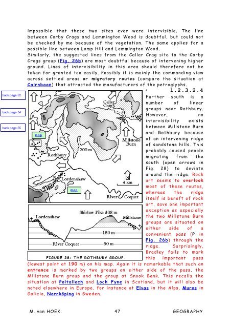
* 1.2.3.2.4<br />
Further south is a<br />
number <strong>of</strong> linear<br />
groups near Rothbury.<br />
However, no<br />
intervisibility exists<br />
between Millstone Burn<br />
<strong>and</strong> Rothbury because<br />
map<br />
<strong>of</strong> an intervening ridge<br />
<strong>of</strong> s<strong>and</strong>stone hills. This<br />
probably caused people<br />
migrating from the<br />
south (open arrows in<br />
Fig. 28) to deviate<br />
around the ridge. Rock<br />
art seems to overlook<br />
most <strong>of</strong> these routes,<br />
map<br />
whereas the ridge<br />
itself is bereft <strong>of</strong> rock<br />
art, save one important<br />
exception as especially<br />
the two Millstone Burn<br />
groups are situated on<br />
either side <strong>of</strong> a<br />
convenient pass (P in<br />
Fig. 26b) through the<br />
ridge. Surprisingly,<br />
Bradley fails to mark<br />
FIGURE 28: THE ROTHBURY GROUP. this important pass<br />
(lowest point at 190 m) on his map. Again it is remarkable that such an<br />
entrance is marked by two groups on either side <strong>of</strong> the pass, the<br />
Millstone Burn group <strong>and</strong> the group at Snook Bank. This recalls the<br />
situation at Poltalloch <strong>and</strong> Loch Fyne in Scotl<strong>and</strong>, but it will also be<br />
noted elsewhere in Europe, for instance at Elvas in the Alps, Muros in<br />
Galicia, Norrköping in Sweden.<br />
M. <strong>van</strong> HOEK: 47 GEOGRAPHY


