

Maarten van Hoek The Geography of Cup-and-Ring ... - StoneWatch
Maarten van Hoek The Geography of Cup-and-Ring ... - StoneWatch
Maarten van Hoek The Geography of Cup-and-Ring ... - StoneWatch

Create successful ePaper yourself
Turn your PDF publications into a flip-book with our unique Google optimized e-Paper software.
across the valley towards Tinizong. <strong>The</strong> view to the south from<br />
Savognin is blocked by high mountains. This slab bears two cupules with<br />
one ring <strong>and</strong> one cupule with possibly four rings all rather crudely<br />
pocked out. <strong>The</strong>re are no grooves <strong>and</strong> no single cupmarks.<br />
* 1.4.1.2.3.1 <strong>The</strong> second route used the San Bernardino pass<br />
(B in Fig. 65) <strong>and</strong> the Via Mala north <strong>of</strong> it. <strong>The</strong> last stretch <strong>of</strong> the Via<br />
Mala (V) just SW <strong>of</strong> Carschenna was (<strong>and</strong> still is) rather dangerous <strong>and</strong><br />
one had to deviate either to the western slopes or turn to the NE via a<br />
steep <strong>and</strong> dangerous scree slope. According to Schwegler (pers. comm.)<br />
this NE route to Lenzerheide via Carschenna played a rather important<br />
role in earlier days.<br />
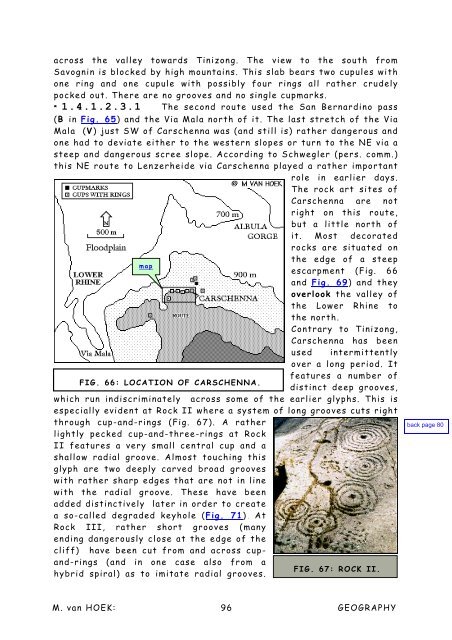
<strong>The</strong> rock art sites <strong>of</strong><br />
Carschenna are not<br />
right on this route,<br />
but a little north <strong>of</strong><br />
it. Most decorated<br />
rocks are situated on<br />
the edge <strong>of</strong> a steep<br />
map<br />
escarpment (Fig. 66<br />
<strong>and</strong> Fig. 69) <strong>and</strong> they<br />
overlook the valley <strong>of</strong><br />
the Lower Rhine to<br />
the north.<br />
Contrary to Tinizong,<br />
Carschenna has been<br />
used intermittently<br />
over a long period. It<br />
features a number <strong>of</strong><br />
FIG. 66: LOCATION OF CARSCHENNA.<br />
distinct deep grooves,<br />
which run indiscriminately across some <strong>of</strong> the earlier glyphs. This is<br />
especially evident at Rock II where a system <strong>of</strong> long grooves cuts right<br />
through cup-<strong>and</strong>-rings (Fig. 67). A rather<br />
lightly pecked cup-<strong>and</strong>-three-rings at Rock<br />
II features a very small central cup <strong>and</strong> a<br />
shallow radial groove. Almost touching this<br />
glyph are two deeply carved broad grooves<br />
with rather sharp edges that are not in line<br />
with the radial groove. <strong>The</strong>se have been<br />
added distinctively later in order to create<br />
a so-called degraded keyhole (Fig. 71). At<br />
Rock III, rather short grooves (many<br />
ending dangerously close at the edge <strong>of</strong> the<br />
cliff) have been cut from <strong>and</strong> across cup<strong>and</strong>-rings<br />
(<strong>and</strong> in one case also from a<br />
FIG. 67: ROCK II.<br />
hybrid spiral) as to imitate radial grooves.<br />
M. <strong>van</strong> HOEK: 96<br />
GEOGRAPHY


