

Maarten van Hoek The Geography of Cup-and-Ring ... - StoneWatch
Maarten van Hoek The Geography of Cup-and-Ring ... - StoneWatch
Maarten van Hoek The Geography of Cup-and-Ring ... - StoneWatch

Create successful ePaper yourself
Turn your PDF publications into a flip-book with our unique Google optimized e-Paper software.
notably remark that the surface <strong>of</strong> that depression had time to erode<br />
before the new cup-<strong>and</strong>-ring figure was added. If this is true, it is<br />
therefore possible that the depression was created by natural forces<br />
long before people started to engrave the rock. Indeed, the outcrop is<br />
fractured in such a way that especially the west edge (B in Fig. 141) is<br />
prone to, for instance, glacial plucking, as well as for quarrying.<br />
Particularly the part with a fine cup-<strong>and</strong>-three-rings still looks very<br />
attractive for removal. Just west <strong>of</strong> this part, another slab is likely to<br />
have been removed either by natural forces or by quarrying.<br />
But even if one assumes that the rock was quarried in prehistoric<br />
times, it then is not at all certain that the removed slab or indeed the<br />
whole rock was already decorated. It is also not certain that the<br />
quarried part indeed was used as a cist slab. Although an exactly<br />
matching piece has not been found locally, there have been recorded a<br />
relatively large number <strong>of</strong> loose decorated stones in the area, many<br />
incorporated into (possible) burial structures <strong>of</strong> the Neolithic <strong>and</strong><br />
Bronze Age. Most portables (from the alleged burials <strong>and</strong> as stray<br />
finds on the moor) are however too small, irregular <strong>and</strong> worn to have<br />
been quarried from outcrop rock.<br />
But some loose stones are suitable c<strong>and</strong>idates to have been possibly<br />
quarried from the North Plantation outcrop. In 1934 a long decorated<br />
stone with flat sides was recorded in the<br />
rampart <strong>of</strong> the enclosure which has been<br />
built on to the North Plantation outcrop<br />
(Beckensall 1983: 127). Unfortunately it<br />
has not been seen since, but it would be<br />
worthwhile to retrace it <strong>and</strong> find out<br />
whether it could have been taken from the<br />
west edge <strong>of</strong> the outcrop. Further<br />
c<strong>and</strong>idates are the loose decorated stones<br />
from Deershed, the Weetwood Moor cairn,<br />
Lilburn Clavering, <strong>and</strong> Wooler (Beckensall<br />
1983).<br />
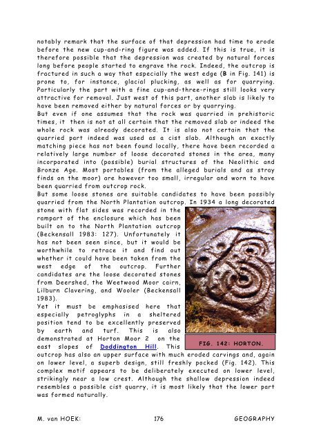
Yet it must be emphasised here that<br />
especially petroglyphs in a sheltered<br />
position tend to be excellently preserved<br />
by earth <strong>and</strong> turf. This is also<br />
demonstrated at Horton Moor 2 on the<br />
FIG. 142: HORTON.<br />
east slopes <strong>of</strong> Doddington Hill. This<br />
outcrop has also an upper surface with much eroded carvings <strong>and</strong>, again<br />
on lower level, a superb design, still freshly pocked (Fig. 142). This<br />
complex motif appears to be deliberately executed on lower level,<br />
strikingly near a low crest. Although the shallow depression indeed<br />
resembles a possible cist quarry, it is most likely that the lower part<br />
was formed naturally.<br />
M. <strong>van</strong> HOEK: 176<br />
GEOGRAPHY


