

Maarten van Hoek The Geography of Cup-and-Ring ... - StoneWatch
Maarten van Hoek The Geography of Cup-and-Ring ... - StoneWatch
Maarten van Hoek The Geography of Cup-and-Ring ... - StoneWatch

Create successful ePaper yourself
Turn your PDF publications into a flip-book with our unique Google optimized e-Paper software.
important rock, No. 1, has more than 350<br />
cupules but also features many grooves <strong>and</strong>,<br />
relatively rare in the Alpine area, cupules<br />
surrounded by one or two ringmarks (Fig. 79),<br />
two with radial grooves (Haller 1989: 172).<br />
When I visited the area in July 1997, I<br />
noticed an unpublished rock decorated with<br />
more than 50 cupules, some connected with<br />
short grooves. I<br />
numbered this rock,<br />
uncovered by an<br />
unknown researcher,<br />
No. 6 (Fig. 80).<br />
FIG. 79: ELVAS 1.<br />
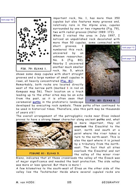
Nearby I uncovered<br />
another much smaller<br />
rock, No. 5, which<br />
shows some deep cupules with short straight<br />
grooves <strong>and</strong> a large number <strong>of</strong> small cupules in<br />
rows, all heavily concentrated (Fig. 81).<br />
Remarkably, both rocks are located directly<br />
west <strong>of</strong> the narrow path (marked 1 in red on<br />
Kompass map 56). <strong>The</strong>ir location on a track<br />
leading up to the other sites may be an echo<br />
from the past, as it is <strong>of</strong>ten seen that<br />
ceremonial paths in the prehistoric l<strong>and</strong>scape<br />
FIG. 80: ELVAS 6.<br />
developed by executing rock symbols. <strong>The</strong>se paths <strong>of</strong>ten continued to<br />
be used in historical times. <strong>The</strong>refore, also this path may be thous<strong>and</strong>s<br />
<strong>of</strong> years old !<br />
<strong>The</strong> overall arrangement <strong>of</strong> the petroglyphic rocks near Elvas indeed<br />
proves to have a strong linear character along ancient paths <strong>and</strong>, what<br />
is more important, they all<br />
overlook the Eisacktal to the<br />
west, north <strong>and</strong> south at a<br />
FIGURE 81: ELVAS 5.<br />
point where the river takes a<br />
turn to the north-west. This is<br />
also the spot where it is joined<br />
by a tributary from the northeast.<br />
<strong>The</strong> fact that all sites<br />
overlook the Eisacktal <strong>and</strong> not<br />
the valley <strong>of</strong> the minor river<br />
Rienz, indicates that at these crossroads the valley <strong>of</strong> the Eisack was<br />
<strong>of</strong> major significance <strong>and</strong> needed the best protection. <strong>The</strong> side valley<br />
was more or less ignored. But there is more !<br />
A few kilometres to the south-west <strong>of</strong> Elvas on the other side <strong>of</strong> the<br />
valley lies the Tschötscher Heide where several cupuled rocks are<br />
M. <strong>van</strong> HOEK: 105<br />
GEOGRAPHY


