

Maarten van Hoek The Geography of Cup-and-Ring ... - StoneWatch
Maarten van Hoek The Geography of Cup-and-Ring ... - StoneWatch
Maarten van Hoek The Geography of Cup-and-Ring ... - StoneWatch

You also want an ePaper? Increase the reach of your titles
YUMPU automatically turns print PDFs into web optimized ePapers that Google loves.
� CHAPTER 1.2.3 �<br />
NORTHUMBERLAND,<br />
VIEW OR INTERVISIBILITY ?<br />
Back from the Canary Isles ? Click this hyperlink !<br />
� INTRODUCTION �<br />
Our third study area in Britain comprises the county <strong>of</strong><br />
Northumberl<strong>and</strong> in the north <strong>of</strong> Engl<strong>and</strong> (Fig. 3). <strong>The</strong> l<strong>and</strong>scape is<br />
characterised by two distinct l<strong>and</strong>forms. On the English-Scottish<br />
border lies the huge volcanic dome <strong>of</strong> the Cheviot Hills consisting <strong>of</strong><br />
lava’s surrounding a granite core. Originally the whole area was covered<br />
by s<strong>and</strong>stones from the Carboniferous, but most <strong>of</strong> this was eroded<br />
away when the dome was pushed upwards. Further away from the dome<br />
the s<strong>and</strong>stone layers remained in situ, but became tilted at first.<br />
Consequently they became eroded by rivers <strong>and</strong> glaciers <strong>and</strong> two<br />
distinct b<strong>and</strong>s <strong>of</strong> harder rock now st<strong>and</strong> out. Especially east <strong>of</strong> the<br />
dome, two ridges <strong>of</strong> s<strong>and</strong>stone dominate the l<strong>and</strong>scape. It is mainly<br />
these ridges where petroglyphs are found; only a few portable<br />
s<strong>and</strong>stones occur in the Cheviot Hills.<br />
* 1.2.3.1 PETROGLYPHS AND GEOMORPHOLOGY *<br />
* 1.2.3.1.1 Availability <strong>of</strong> suitable stone surfaces is the prime<br />
condition for rock art to develop in an area. In this respect we may<br />
distinguish four geomorphologic<br />
features in Northumberl<strong>and</strong> that are<br />
related to the tilted position <strong>of</strong> the<br />
hard s<strong>and</strong>stone layers. In the valleys<br />
there are no outcrop rocks, as these<br />
have been silted up a long time ago.<br />
<strong>The</strong>n there are the impressive scarp<br />
slopes <strong>of</strong> hard s<strong>and</strong>stone, <strong>of</strong>fering many<br />
suitable but mainly vertical surfaces.<br />
Only three sites in Northumberl<strong>and</strong><br />
have petroglyphs on vertical surfaces.<br />
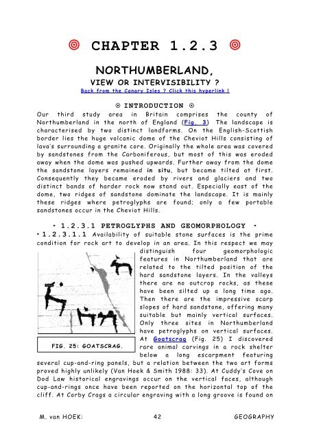
At Goatscrag (Fig. 25) I discovered<br />
FIG. 25: GOATSCRAG. rare animal carvings in a rock shelter<br />
below a long escarpment featuring<br />
several cup-<strong>and</strong>-ring panels, but a relation between the two art forms<br />
proved highly unlikely (Van <strong>Hoek</strong> & Smith 1988: 33). At Cuddy’s Cove on<br />
Dod Law historical engravings occur on the vertical faces, although<br />
cup-<strong>and</strong>-rings once have been reported on the horizontal top <strong>of</strong> the<br />
cliff. At Corby Crags a circular engraving with a long groove is found on<br />
M. <strong>van</strong> HOEK: 42 GEOGRAPHY


