

Maarten van Hoek The Geography of Cup-and-Ring ... - StoneWatch
Maarten van Hoek The Geography of Cup-and-Ring ... - StoneWatch
Maarten van Hoek The Geography of Cup-and-Ring ... - StoneWatch

Create successful ePaper yourself
Turn your PDF publications into a flip-book with our unique Google optimized e-Paper software.
FIG. 9: THE ‘X’-SETTING,<br />
NETHER LARGIE<br />
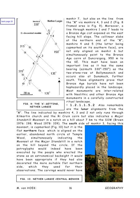
FIG. 10. NETHER LARGIE CENTRAL MENHIR<br />
menhir 7, but also on the line from<br />
the “X” via menhirs 4, 3 <strong>and</strong> 2 (Fig. 8<br />
framed area is Fig. 9). Moreover, a<br />
line through menhirs 1 <strong>and</strong> 7 leads to<br />
a Bronze Age cist exposed on the east<br />
facing hill slope. <strong>The</strong> collinear slabs<br />
at the northern end <strong>of</strong> the “X”,<br />
menhirs 4 <strong>and</strong> 5 (the latter being<br />
cupmarked on its southern face), are<br />
not only aligned on menhir 6 but<br />
simultaneously point to the Bronze<br />
Age cairn at Duncraigaig, 950 m to<br />
the SE. This must have been an<br />
important line as it has the same<br />
bearing (azimuth 330°-150°) as the<br />
two-stone-row at Ballymeanoch <strong>and</strong><br />
occurs also at Dunamuck, further<br />
south. <strong>The</strong>se alignments prove that<br />
Bronze Age burials have not been<br />
haphazardly placed in the l<strong>and</strong>scape.<br />
Most monuments are inter-related<br />
with Neolithic <strong>and</strong> other Bronze Age<br />
monuments in a carefully constructed<br />
ritual l<strong>and</strong>scape.<br />
* 1.2.1.1.5.2 Also remarkable<br />
are the lunar alignments from the<br />
“X”. <strong>The</strong> line indicated by menhirs 4, 3 <strong>and</strong> 2 not only runs through<br />
Kilmartin church <strong>and</strong> the Ri Cruin cairn but also indicates a Major<br />
St<strong>and</strong>still Moonset in a notch on a hill about 7 km to the SSW (Brown<br />
1976: 198; Wood 1978: 109). <strong>The</strong> south side <strong>of</strong> menhir 3, facing this<br />
moonset, is cupmarked (Fig. 10) but it is the<br />
flat northern face which is aligned on the<br />
earlier, ab<strong>and</strong>oned north circle at Temple<br />
Wood, simultaneously indicating the<br />
Moonset at the Major St<strong>and</strong>still in a notch<br />
on the hill beyond the circle. If the<br />
petroglyphs would indeed have been<br />
executed by the people who erected the<br />
stone as an astronomical backsight it would<br />
have been appropriate if they had also<br />
decorated the more suitable flat northern<br />
side, which they used for their<br />
observations. <strong>The</strong> carvings would never have<br />
M. <strong>van</strong> HOEK: 16<br />
GEOGRAPHY


