

Maarten van Hoek The Geography of Cup-and-Ring ... - StoneWatch
Maarten van Hoek The Geography of Cup-and-Ring ... - StoneWatch
Maarten van Hoek The Geography of Cup-and-Ring ... - StoneWatch

Create successful ePaper yourself
Turn your PDF publications into a flip-book with our unique Google optimized e-Paper software.
argue that all these sites comm<strong>and</strong> extensive views into the lower<br />
ground <strong>of</strong> the San Francisco valley (1995: 357), this definitely is not<br />
true for the site at O Cruceiro, which moreover is located on the wrong<br />
spot on their map; it should be situated at least 300 m further east<br />
(Fig. 36). O Cruceiro is a most extensive <strong>and</strong> steeply south sloping<br />
outcrop area, where only one cup-<strong>and</strong>-three-rings was reported.<br />
Inspection <strong>of</strong> the site, however, revealed at least two more single<br />
cupules. From O Cruceiro, on top <strong>of</strong> a cliff <strong>and</strong> directly high above the<br />
beach, the other sites are definitely invisible, but there is a splendid<br />
view <strong>of</strong> the beach <strong>of</strong> San Francisco <strong>and</strong> the Louro peninsula with its<br />
distinct solitary hill. This resembles the situation at Mogor near<br />
Pontevedra, where a major cup-<strong>and</strong>ring<br />
site overlooks a most accessible<br />
s<strong>and</strong>y beach, but also many sites in<br />
Scotl<strong>and</strong> similarly overlook beaches or<br />
small bays suitable as l<strong>and</strong>ing places<br />
(Monreith <strong>and</strong> Garlieston in Galloway;<br />
Ardifur <strong>and</strong> Poltalloch in Argyll).<br />
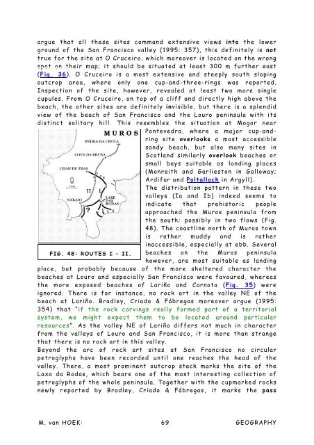
<strong>The</strong> distribution pattern in these two<br />
valleys (Ia <strong>and</strong> Ib) indeed seems to<br />
indicate that prehistoric people<br />
approached the Muros peninsula from<br />
the south; possibly in two flows (Fig.<br />
48). <strong>The</strong> coastline north <strong>of</strong> Muros town<br />
is rather muddy <strong>and</strong> is rather<br />
inaccessible, especially at ebb. Several<br />
FIG. 48: ROUTES I – II. beaches on the Muros peninsula<br />
however, are most suitable as l<strong>and</strong>ing<br />
place, but probably because <strong>of</strong> the more sheltered character the<br />
beaches at Louro <strong>and</strong> especially San Francisco were favoured, whereas<br />
the more exposed beaches <strong>of</strong> Lariño <strong>and</strong> Carnota (Fig. 35) were<br />
ignored. <strong>The</strong>re is for instance, no rock art in the valley NE <strong>of</strong> the<br />
beach at Lariño. Bradley, Criado & Fábregas moreover argue (1995:<br />
354) that “if the rock carvings really formed part <strong>of</strong> a territorial<br />
system, we might expect them to be located around particular<br />
resources”. As the valley NE <strong>of</strong> Lariño differs not much in character<br />
from the valleys <strong>of</strong> Louro <strong>and</strong> San Francisco, it is more than strange<br />
that there is no rock art in this valley.<br />
Beyond the arc <strong>of</strong> rock art sites at San Francisco no circular<br />
petroglyphs have been recorded until one reaches the head <strong>of</strong> the<br />
valley. <strong>The</strong>re, a most prominent outcrop stack marks the site <strong>of</strong> the<br />
Laxa da Rodas, which bears one <strong>of</strong> the most interesting collection <strong>of</strong><br />
petroglyphs <strong>of</strong> the whole peninsula. Together with the cupmarked rocks<br />
newly reported by Bradley, Criado & Fábregas, it marks the pass<br />
M. <strong>van</strong> HOEK: 69 GEOGRAPHY


