

Maarten van Hoek The Geography of Cup-and-Ring ... - StoneWatch
Maarten van Hoek The Geography of Cup-and-Ring ... - StoneWatch
Maarten van Hoek The Geography of Cup-and-Ring ... - StoneWatch

You also want an ePaper? Increase the reach of your titles
YUMPU automatically turns print PDFs into web optimized ePapers that Google loves.
Vigo <strong>and</strong> the peninsula <strong>of</strong> Morrazo beyond. An outcrop rock at lower<br />
level with eleven single cupules is also located in a remarkably secluded<br />
position. <strong>The</strong>se examples seem to indicate that wide views <strong>of</strong> the sea<br />
were avoided on purpose or at least not favoured.<br />
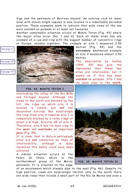
Another remarkable situation occurs at Monte Teton (Fig. 43) where<br />
two major sites occur (No. 1 <strong>and</strong> 4). Each <strong>of</strong> these sites has one<br />
example <strong>of</strong> a cup-<strong>and</strong>-ring with the biggest number <strong>of</strong> concentric rings<br />
<strong>of</strong> Europe, notably eighteen. <strong>The</strong> example at site 1 measures 2.50<br />
metres (Fig. 44) <strong>and</strong> the<br />
extremely weathered example<br />
at site 4 measures almost 3.50<br />
metres.<br />
<strong>The</strong> description by Costas<br />
(1991: 90) may give the<br />
impression that these two<br />
sites are intervisible, but it<br />
seems as if this has been<br />
avoided on purpose. Site 1 has<br />
its main view to the south,<br />
FIG. 44: MONTE TETON I.<br />
overlooking the valley <strong>of</strong> the Rio Miño<br />
<strong>and</strong> Portugal beyond. Although the<br />
views to the north are blocked by the<br />
hill, the ridge on which site 4 is<br />
located is visible, but not the<br />
decorated outcrop. But surprisingly<br />
the view from site 4 towards site 1 is<br />
completely blocked by a rocky ridge <strong>of</strong><br />
about 3 m high, directly SE <strong>of</strong> site 4.<br />
<strong>The</strong>refore, site 4 has its main view to<br />
the west <strong>and</strong> overlooks an important<br />
pass (Fig. 45).<br />
It is clear that in Galicia petroglyph<br />
sites are not connected by lines <strong>of</strong><br />
intervisibility, although in many<br />
instances this easily could have been<br />
achieved.<br />
A similar situation occurs at the<br />
Pedra da Chula, which is the<br />
northernmost group <strong>of</strong> the Muros FIG. 45: MONTE TETON IV.<br />
peninsula. It is situated on the edge<br />
<strong>of</strong> an escarpment which steeply dips to the east (Fig. 46). Despite its<br />
high position, views are surprisingly limited; only to the south there<br />
are wide views that include a small part <strong>of</strong> the Ria de Muros <strong>and</strong> even a<br />
M. <strong>van</strong> HOEK: 64 GEOGRAPHY


