- Page 2 and 3:
i\1 -■-'^^.■■--y^lEil^peD
- Page 4 and 5:
The Praetorian STARShip The Untold
- Page 6 and 7:
This book is dedicated to all Speci
- Page 8 and 9:
Contents Chapter Page DISCLAIMER .
- Page 10 and 11:
Figure Page 13 Template Shift Due t
- Page 12 and 13:
Page Col Don Britton, First Command
- Page 14 and 15:
Page Aircraft 74-1683 Crashes onto
- Page 16 and 17:
Foreword As a young lieutenant flyi
- Page 18 and 19:
About the Author USAF Photo Col Jer
- Page 20 and 21:
The third factor driving approval o
- Page 22 and 23:
A Word from the Commander We in Air
- Page 24 and 25: was changed forever. The US Army Wa
- Page 26 and 27: Introduction Welcome to the world o
- Page 28 and 29: system, the following three chapter
- Page 30 and 31: move was partially driven by the Ai
- Page 32 and 33: Chapter 1 Establishment of Combat T
- Page 34 and 35: ESTABLISHMENT OF COMBAT TALON coloc
- Page 36 and 37: ESTABLISHMENT OF COMBAT TALON Two d
- Page 38 and 39: ESTABLISHMENT OF COMBAT TALON immed
- Page 40 and 41: ESTABLISHMENT OF COMBAT TALON Life
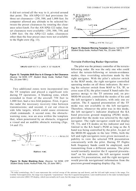
- Page 42 and 43: ESTABLISHMENT OF COMBAT TALON condu
- Page 44 and 45: ESTABLISHMENT OF COMBAT TALON Precu
- Page 46 and 47: ESTABLISHMENT OF COMBAT TALON were
- Page 48 and 49: ESTABLISHMENT OF COMBAT TALON SOG h
- Page 50 and 51: Chapter 2 The Combat Talon Weapons
- Page 52 and 53: although the early Fulton modificat
- Page 54 and 55: THE COMBAT TALON WEAPONS SYSTEM tri
- Page 56 and 57: THE COMBAT TALON WEAPONS SYSTEM Lt
- Page 58 and 59: THE COMBAT TALON WEAPONS SYSTEM as
- Page 60 and 61: THE COMBAT TALON WEAPONS SYSTEM mis
- Page 62 and 63: THE COMBAT TALON WEAPONS SYSTEM F^C
- Page 64 and 65: THE COMBAT TALON WEAPONS SYSTEM The
- Page 66 and 67: THE COMBAT TALON WEAPONS SYSTEM ./
- Page 68 and 69: ■ ■-:'■-:;■ ■■..kFTn \
- Page 70 and 71: equipment malfunctioned, the more t
- Page 72 and 73: THE COMBAT TALON WEAPONS SYSTEM top
- Page 76 and 77: THE COMBAT TALON WEAPONS SYSTEM TEP
- Page 78 and 79: THE COMBAT TALON WEAPONS SYSTEM CRu
- Page 80 and 81: Yank aircraft operating in the Paci
- Page 82 and 83: THE COMBAT TALON WEAPONS SYSTEM Fig
- Page 84 and 85: THE COMBAT TALON WEAPONS SYSTEM ly
- Page 86 and 87: TYPICAl TANKER ORBIT PATTERN THE CO
- Page 88 and 89: THE COMBAT TALON WEAPONS SYSTEM Not
- Page 90 and 91: PRAETORIAN STARSHIP Once the Stray
- Page 92 and 93: PRAETORIAN STARSHIP 1968: The Estab
- Page 94 and 95: PRAETORIAN STARSHIP ridgeline. John
- Page 96 and 97: PRAETORIAN STARSHIP that it was a t
- Page 98 and 99: PRAETORIAN STARSHIP terrain followi
- Page 100 and 101: PRAETORIAN STARSHIP to intercept th
- Page 102 and 103: PRAETORIAN STARSHIP assigned to the
- Page 104 and 105: PRAETORIAN STARSHIP making multiple
- Page 106 and 107: Chapter 4 Combat Spear (The Vietnam
- Page 108 and 109: COMBAT SPEAR quarters and were prov
- Page 110 and 111: COMBAT SPEAR f -fpadc khi ai b6 phr
- Page 112 and 113: COMBAT SPEAR The study cited the fo
- Page 114 and 115: COMBAT SPEAR rn nilMirif Piti.r,,!
- Page 116 and 117: COMBAT SPEAR proper crew rest could
- Page 118 and 119: COMBAT SPEAR proper people. Moreove
- Page 120 and 121: COMBAT SPEAR we never intended to e
- Page 122 and 123: COMBAT SPEAR Christmas spirit and j
- Page 124 and 125:
COMBAT SPEAR ■ IBDCITI |«'4llH^
- Page 126 and 127:
COMBAT SPEAR with good radar target
- Page 128 and 129:
COMBAT SPEAR two loadmasters, and t
- Page 130 and 131:
COMBAT SPEAR was given up. The crew
- Page 132 and 133:
COMBAT SPEAR killed, and 187 were w
- Page 134 and 135:
COMBAT SPEAR volunteers shortly aft
- Page 136 and 137:
COMBAT SPEAR were provided to SOG b
- Page 138 and 139:
COMBAT SPEAR early as January 1970.
- Page 140 and 141:
COMBAT SPEAR r esources resulted. A
- Page 142 and 143:
COMBAT SPEAR live surface-to-air pi
- Page 144 and 145:
served as the squadron’s administ
- Page 146 and 147:
COMBAT SPEAR Korean government. 139
- Page 148 and 149:
COMBAT SPEAR marked the beginning o
- Page 150 and 151:
COMBAT SPEAR 76. History, 14th Spec
- Page 152 and 153:
PRAETORIAN STARSHIP Sembach AB to R
- Page 154 and 155:
PRAETORIAN STARSHIP Combat Talon de
- Page 156 and 157:
PRAETORIAN STARSHIP June also saw t
- Page 158 and 159:
PRAETORIAN STARSHIP prisoners of wa
- Page 160 and 161:
PRAETORIAN STARSHIP and presenting
- Page 162 and 163:
PRAETORIAN STARSHIP 1973: Combat Ta
- Page 164 and 165:
PRAETORIAN STARSHIP experienced wit
- Page 166 and 167:
Chapter 6 The Son Tay Prisoner of W
- Page 168 and 169:
THE SON TAY PRISONER OF WAR RAID On
- Page 170 and 171:
THE SON TAY PRISONER OF WAR RAID cr
- Page 172 and 173:
THE SON TAY PRISONER OF WAR RAID Tr
- Page 174 and 175:
THE SON TAY PRISONER OF WAR RAID al
- Page 176 and 177:
THE SON TAY PRISONER OF WAR RAID th
- Page 178 and 179:
THE SON TAY PRISONER OF WAR RAID RT
- Page 180 and 181:
THE SON TAY PRISONER OF WAR RAID se
- Page 182 and 183:
THE SON TAY PRISONER OF WAR RAID ob
- Page 184 and 185:
THE SON TAY PRISONER OF WAR RAID se
- Page 186 and 187:
Chapter 7 Between the Wars (1975-79
- Page 188 and 189:
BETWEEN THE WARS Tentatively, the p
- Page 190 and 191:
BETWEEN THE WARS be undertaken in M
- Page 192 and 193:
BETWEEN THE WARS was established as
- Page 194 and 195:
BETWEEN THE WARS From 28 March to 1
- Page 196 and 197:
BETWEEN THE WARS The 7575th OG exer
- Page 198 and 199:
BETWEEN THE WARS The last half of t
- Page 200 and 201:
BETWEEN THE WARS during 1978 the sq
- Page 202 and 203:
BETWEEN THE WARS Italy for the firs
- Page 204 and 205:
BETWEEN THE WARS SOW CCT member lin
- Page 206 and 207:
Chapter 8 The Iranian Rescue Missio
- Page 208 and 209:
THE IRANIAN RESCUE MISSION shah had
- Page 210 and 211:
THE IRANIAN RESCUE MISSION were oth
- Page 212 and 213:
The 1st SOW maintained the four gun
- Page 214 and 215:
THE IRANIAN RESCUE MISSION Crew 1 C
- Page 216 and 217:
THE IRANIAN RESCUE MISSION large ru
- Page 218 and 219:
THE IRANIAN RESCUE MISSION helicopt
- Page 220 and 221:
THE IRANIAN RESCUE MISSION or barra
- Page 222 and 223:
THE IRANIAN RESCUE MISSION Since th
- Page 224 and 225:
executing the mission. Kyle had jus
- Page 226 and 227:
THE IRANIAN RESCUE MISSION addition
- Page 228 and 229:
THE IRANIAN RESCUE MISSION where he
- Page 230 and 231:
THE IRANIAN RESCUE MISSION the resc
- Page 232 and 233:
equired eight and one-half hours of
- Page 234 and 235:
The prototype Benson tank was opera
- Page 236 and 237:
NVG landings. Because of the short
- Page 238 and 239:
THE IRANIAN RESCUE MISSION the 1st
- Page 240 and 241:
THE IRANIAN RESCUE MISSION of the C
- Page 242 and 243:
THE IRANIAN RESCUE MISSION transmis
- Page 244 and 245:
THE IRANIAN RESCUE MISSION Photo co
- Page 246 and 247:
THE IRANIAN RESCUE MISSION Photo co
- Page 248 and 249:
THE IRANIAN RESCUE MISSION Fleming
- Page 250 and 251:
THE IRANIAN RESCUE MISSION had land
- Page 252 and 253:
THE IRANIAN RESCUE MISSION outside
- Page 254 and 255:
THE IRANIAN RESCUE MISSION ^f5
- Page 256 and 257:
THE IRANIAN RESCUE MISSION vertical
- Page 258 and 259:
THE IRANIAN RESCUE MISSION a decisi
- Page 260 and 261:
THE IRANIAN RESCUE MISSION Notes 1.
- Page 262 and 263:
Chapter 9 Project Honey Badger and
- Page 264 and 265:
PROJECT HONEY BADGER AND CREDIBLE S
- Page 266 and 267:
adar system similar to the Combat T
- Page 268 and 269:
PROJECT HONEY BADGER AND CREDIBLE S
- Page 270 and 271:
PROJECT HONEY BADGER AND CREDIBLE S
- Page 272 and 273:
PROJECT HONEY BADGER AND CREDIBLE S
- Page 274 and 275:
PROJECT HONEY BADGER AND CREDIBLE S
- Page 276 and 277:
0428 local, made its tactical landi
- Page 278 and 279:
Chapter 10 From Desert One to Point
- Page 280 and 281:
Talon community. 8 The IFR modifica
- Page 282 and 283:
FROM DESERT ONE TO POINT SALINES an
- Page 284 and 285:
FROM DESERT ONE TO POINT SALINES sq
- Page 286 and 287:
exercise aircraft on the ground wer
- Page 288 and 289:
standard operating procedures for c
- Page 290 and 291:
FROM DESERT ONE TO POINT SALINES un
- Page 292 and 293:
to MAC’s newly formed Twenty-Thir
- Page 294 and 295:
FROM DESERT ONE TO POINT SALINES se
- Page 296 and 297:
FROM DESERT ONE TO POINT SALINES an
- Page 298 and 299:
plan, Colonel Hudspeth arrived in t
- Page 300 and 301:
FROM DESERT ONE TO POINT SALINES At
- Page 302 and 303:
FROM DESERT ONE TO POINT SALINES MA
- Page 304 and 305:
for five Combat Talons, Hobson and
- Page 306 and 307:
FROM DESERT ONE TO POINT SALINES US
- Page 308 and 309:
FROM DESERT ONE TO POINT SALINES de
- Page 310 and 311:
FROM DESERT ONE TO POINT SALINES as
- Page 312 and 313:
il-u Grenada Firlih Hunlfe^ Fiuil
- Page 314 and 315:
FROM DESERT ONE TO POINT SALINES th
- Page 316 and 317:
FROM DESERT ONE TO POINT SALINES 10
- Page 318 and 319:
PRAETORIAN STARSHIP five-light syst
- Page 320 and 321:
PRAETORIAN STARSHIP the total force
- Page 322 and 323:
PRAETORIAN STARSHIP interest the co
- Page 324 and 325:
PRAETORIAN STARSHIP operations exer
- Page 326 and 327:
PRAETORIAN STARSHIP forces in being
- Page 328 and 329:
PRAETORIAN STARSHIP 1986: The Goldw
- Page 330 and 331:
PRAETORIAN STARSHIP With rumors swi
- Page 332 and 333:
PRAETORIAN STARSHIP Photo courtesy
- Page 334 and 335:
PRAETORIAN STARSHIP all on-aircraft
- Page 336 and 337:
PRAETORIAN STARSHIP Dur ing the fol
- Page 338 and 339:
PRAETORIAN STARSHIP the ORI overwhe
- Page 340 and 341:
PRAETORIAN STARSHIP H ■ BB a FT-
- Page 342 and 343:
PRAETORIAN STARSHIP 28. History, 2d
- Page 344 and 345:
PRAETORIAN STARSHIP ranks to become
- Page 346 and 347:
PRAETORIAN STARSHIP continued to ve
- Page 348 and 349:
PRAETORIAN STARSHIP process. Events
- Page 350 and 351:
PRAETORIAN STARSHIP launch. By 1730
- Page 352 and 353:
PRAETORIAN STARSHIP USAF Photo Crew
- Page 354 and 355:
PRAETORIAN STARSHIP spacing between
- Page 356 and 357:
PRAETORIAN STARSHIP vegetation grow
- Page 358 and 359:
PRAETORIAN STARSHIP Task Force Blac
- Page 360 and 361:
PRAETORIAN STARSHIP JTF-South force
- Page 362 and 363:
PRAETORIAN STARSHIP 21. Ibid. 22. I
- Page 364 and 365:
PRAETORIAN STARSHIP Cope Thunder Wi
- Page 366 and 367:
PRAETORIAN STARSHIP the first night
- Page 368 and 369:
PRAETORIAN STARSHIP Within days of
- Page 370 and 371:
PRAETORIAN STARSHIP SOW forces lean
- Page 372 and 373:
PRAETORIAN STARSHIP was “not bad.
- Page 374 and 375:
PRAETORIAN STARSHIP --7^*—1^, ■
- Page 376 and 377:
PRAETORIAN STARSHIP USAF Photo Crew
- Page 378 and 379:
PRAETORIAN STARSHIP USAF Photo Crew
- Page 380 and 381:
PRAETORIAN STARSHIP USAF Photo Crew
- Page 382 and 383:
PRAETORIAN STARSHIP ready for testi
- Page 384 and 385:
PRAETORIAN STARSHIP start of the ai
- Page 386 and 387:
PRAETORIAN STARSHIP Orrell had depl
- Page 388 and 389:
PRAETORIAN STARSHIP 16 January the
- Page 390 and 391:
PRAETORIAN STARSHIP Saudi Arabia. H
- Page 392 and 393:
PRAETORIAN STARSHIP experts destroy
- Page 394 and 395:
Chapter 14 Mount Pinatubo to Operat
- Page 396 and 397:
MOUNT PINATUBO TO OPERATION JOINT E
- Page 398 and 399:
major eruption occurred. Seismograp
- Page 400 and 401:
MOUNT PINATUBO TO OPERATION JOINT E
- Page 402 and 403:
MOUNT PINATUBO TO OPERATION JOINT E
- Page 404 and 405:
headquarters. For AFSOC McPeak’s
- Page 406 and 407:
culmination of years of hard work b
- Page 408 and 409:
MOUNT PINATUBO TO OPERATION JOINT E
- Page 410 and 411:
MOUNT PINATUBO TO OPERATION JOINT E
- Page 412 and 413:
flew a SOCEUR assessment team into
- Page 414 and 415:
Early in the spring of 1993, all th
- Page 416 and 417:
MOUNT PINATUBO TO OPERATION JOINT E
- Page 418 and 419:
MOUNT PINATUBO TO OPERATION JOINT E
- Page 420 and 421:
MOUNT PINATUBO TO OPERATION JOINT E
- Page 422 and 423:
MOUNT PINATUBO TO OPERATION JOINT E
- Page 424 and 425:
MOUNT PINATUBO TO OPERATION JOINT E
- Page 426 and 427:
MOUNT PINATUBO TO OPERATION JOINT E
- Page 428 and 429:
MOUNT PINATUBO TO OPERATION JOINT E
- Page 430 and 431:
MOUNT PINATUBO TO OPERATION JOINT E
- Page 432 and 433:
MOUNT PINATUBO TO OPERATION JOINT E
- Page 434 and 435:
MOUNT PINATUBO TO OPERATION JOINT E
- Page 436 and 437:
MOUNT PINATUBO TO OPERATION JOINT E
- Page 438 and 439:
MOUNT PINATUBO TO OPERATION JOINT E
- Page 440 and 441:
MOUNT PINATUBO TO OPERATION JOINT E
- Page 442 and 443:
MOUNT PINATUBO TO OPERATION JOINT E
- Page 444 and 445:
Chapter 15 Operation Assured Respon
- Page 446 and 447:
OPERATION ASSURED RESPONSE TO THE N
- Page 448 and 449:
OPERATION ASSURED RESPONSE TO THE N
- Page 450 and 451:
OPERATION ASSURED RESPONSE TO THE N
- Page 452 and 453:
fuel available at the new location
- Page 454 and 455:
OPERATION ASSURED RESPONSE TO THE N
- Page 456 and 457:
OPERATION ASSURED RESPONSE TO THE N
- Page 458 and 459:
OPERATION ASSURED RESPONSE TO THE N
- Page 460 and 461:
OPERATION ASSURED RESPONSE TO THE N
- Page 462 and 463:
OPERATION ASSURED RESPONSE TO THE N
- Page 464 and 465:
OPERATION ASSURED RESPONSE TO THE N
- Page 466 and 467:
OPERATION ASSURED RESPONSE TO THE N
- Page 468 and 469:
OPERATION ASSURED RESPONSE TO THE N
- Page 470 and 471:
OPERATION ASSURED RESPONSE TO THE N
- Page 472 and 473:
OPERATION ASSURED RESPONSE TO THE N
- Page 474 and 475:
OPERATION ASSURED RESPONSE TO THE N
- Page 476 and 477:
OPERATION ASSURED RESPONSE TO THE N
- Page 478 and 479:
OPERATION ASSURED RESPONSE TO THE N
- Page 480 and 481:
OPERATION ASSURED RESPONSE TO THE N
- Page 482 and 483:
OPERATION ASSURED RESPONSE TO THE N
- Page 484 and 485:
OPERATION ASSURED RESPONSE TO THE N
- Page 486 and 487:
Epilogue 2000 and Beyond: A Combat
- Page 488 and 489:
surface will be covered by layers o
- Page 490 and 491:
Live Fulton STARS Made by Combat Ta
- Page 492 and 493:
Person Date Location Recovery Pilot
- Page 494 and 495:
Partial Summary of Upgrades, MOD-90
- Page 496 and 497:
—X Band Receiver/Transmitter: On
- Page 498 and 499:
Glossary AAA AAF ABCCC ABW ACS AD A
- Page 500 and 501:
CTJTF CTMR CTW CV DCS DCSO DIA DMZ
- Page 502 and 503:
MATS MC MCAS MCM MEU MFF MFP MIA MO
- Page 504 and 505:
SKE SLOG SMM SOAR SOCCENT SOCCT SOC
- Page 506 and 507:
Index Aircraft B-17: 2-4, 15, 17, 2
- Page 508 and 509:
Far East Command (FECOM): 5-8 Fulto


![Combat Support in Korea [270 Pages] - The Black Vault](https://img.yumpu.com/49796461/1/190x71/combat-support-in-korea-270-pages-the-black-vault.jpg?quality=85)