EMI Course Catalog - Emergency Management Institute - Federal ...
EMI Course Catalog - Emergency Management Institute - Federal ...
EMI Course Catalog - Emergency Management Institute - Federal ...
Create successful ePaper yourself
Turn your PDF publications into a flip-book with our unique Google optimized e-Paper software.
RESIDENT COURSES—<br />
HAZUS-MH<br />
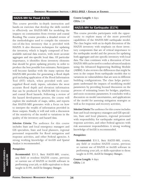
HAZUS-MH for Flood (E172)<br />
EmErgEncy managEmEnt InstItutE • 2011-2012 • catalog of coursEs<br />
This course provides in-depth instruction and<br />
hands-on exercises that develop the skills needed<br />
to effectively use HAZUS-MH for modeling the<br />
impacts on communities from riverine and coastal<br />
flooding. The course provides a detailed review of<br />
the methodologies used to compile the extensive<br />
out-of-the-box inventory that is provided with<br />
HAZUS. It also discusses techniques for updating<br />
the inventory, which is largely composed of bestavailable<br />
national data sources, with more accurate<br />
aggregate and site-specific local data. Of particular<br />
importance, it identifies those inventory elements<br />
that should be given updating priority in order to<br />
produce the best possible loss estimates. Participants<br />
will become familiar with the many options that<br />
HAZUS-MH provides for generating a flood depth<br />
grid including application of the Flood Information<br />
Tool (FIT) which, when provided with usersupplied<br />
flood study inputs, calculates the most<br />
accurate flood depth and elevation information<br />
that can be produced by HAZUS-MH for riverine<br />
and coastal flood hazards. Following a review of<br />
the hazard development process, the course will<br />
explore the multitude of maps, tables, and reports<br />
that HAZUS-MH generates with a focus on how<br />
to interpret the wealth of information provided in<br />
these outputs. Finally, it will end with a discussion<br />
of the sensitivity of the model to variations in the<br />
quality of the inventory and hazard data.<br />
Selection Criteria: The audience for this course<br />
includes State and local emergency managers and<br />
GIS specialists, State and local planners, regional<br />
personnel responsible for flood mitigation and<br />
response activities, and other <strong>Federal</strong> agencies. A<br />
strong working knowledge of ArcGIS and Spatial<br />
Analyst is recommended.<br />
Prerequisites:<br />
Recommended: E313, Basic HAZUS-MH, course,<br />
any field or resident HAZUS course, previous<br />
or current use of HAZUS or ArcGIS software in<br />
performing your job, or skills equivalent to those<br />
taught in E190, ArcGIS for <strong>Emergency</strong> Managers.<br />
FEdErAL EmErgENCy mANAgEmENT AgENCy 34<br />
<strong>Course</strong> Length: 4 days<br />
CEUs: 2.8<br />
HAZUS-MH for Earthquake (E174)<br />
This course provides participants with the opportunity<br />
to explore many of the more powerful<br />
capabilities of the HAZUS-MH earthquake model.<br />
The class begins with an in-depth discussion of the<br />
HAZUS inventory with emphasis on those inventory<br />
components that are of critical importance to<br />
the earthquake model and the process for updating<br />
both aggregate and site-specific inventory with local<br />
data. The class continues with a discussion of how<br />
HAZUS-MH can be used to conduct advanced analysis<br />
using the Advanced Engineering Building Module<br />
(AEBM). It also reviews the differences that might be<br />
seen in the output from earthquake models due to<br />
variations in vulnerabilities that are seen in different<br />
building configurations. The class helps participants<br />
understand the impacts of modifying model<br />
parameters by providing focused discussion on the<br />
process of estimating losses for bridges, pipelines,<br />
and socio-economic parameters. It concludes with a<br />
discussion on model uncertainties, and applications<br />
of the model for assessing mitigation strategies as<br />
well as for response and recovery activities.<br />
Selection Criteria: The audience for this course includes<br />
State and local emergency managers and GIS specialists,<br />
State and local planners, regional personnel<br />
with responsibility for earthquake mitigation and<br />
response activities, and other <strong>Federal</strong> agencies with<br />
risk assessment responsibilities. A strong working<br />
knowledge of ArcGIS is recommended.<br />
Prerequisites:<br />
Recommended: E313, Basic HAZUS-MH, course,<br />
any field or resident HAZUS course, previous<br />
or current use of HAZUS or ArcGIS software in<br />
performing your job, or skills equivalent to those<br />
taught in E190, ArcGIS for <strong>Emergency</strong> Managers.<br />
<strong>Course</strong> Length: 4 days<br />
CEUs: 2.8


