EMI Course Catalog - Emergency Management Institute - Federal ...
EMI Course Catalog - Emergency Management Institute - Federal ...
EMI Course Catalog - Emergency Management Institute - Federal ...
You also want an ePaper? Increase the reach of your titles
YUMPU automatically turns print PDFs into web optimized ePapers that Google loves.
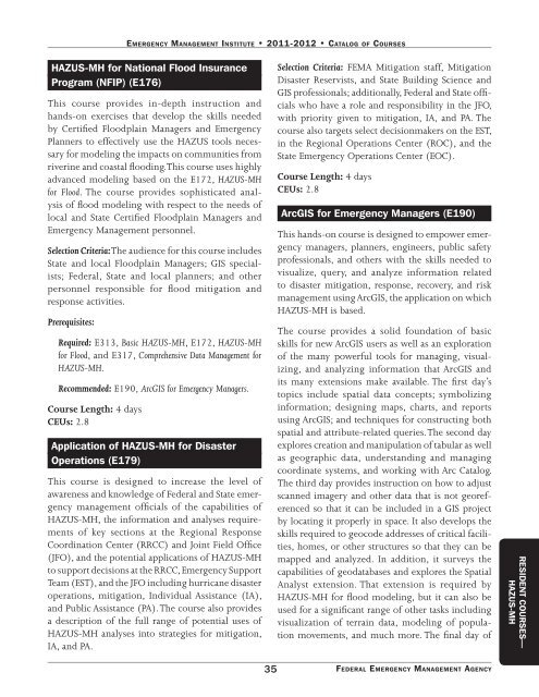
EmErgEncy managEmEnt InstItutE • 2011-2012 • catalog of coursEs<br />
HAZUS-MH for National Flood Insurance<br />
Program (NFIP) (E176)<br />
This course provides in-depth instruction and<br />
hands-on exercises that develop the skills needed<br />
by Certified Floodplain Managers and <strong>Emergency</strong><br />
Planners to effectively use the HAZUS tools necessary<br />
for modeling the impacts on communities from<br />
riverine and coastal flooding. This course uses highly<br />
advanced modeling based on the E172, HAZUS-MH<br />
for Flood. The course provides sophisticated analysis<br />
of flood modeling with respect to the needs of<br />
local and State Certified Floodplain Managers and<br />
<strong>Emergency</strong> <strong>Management</strong> personnel.<br />
Selection Criteria: The audience for this course includes<br />
State and local Floodplain Managers; GIS specialists;<br />
<strong>Federal</strong>, State and local planners; and other<br />
personnel responsible for flood mitigation and<br />
response activities.<br />
Prerequisites:<br />
Required: E313, Basic HAZUS-MH, E172, HAZUS-MH<br />
for Flood, and E317, Comprehensive Data <strong>Management</strong> for<br />
HAZUS-MH.<br />
Recommended: E190, ArcGIS for <strong>Emergency</strong> Managers.<br />
<strong>Course</strong> Length: 4 days<br />
CEUs: 2.8<br />
Application of HAZUS-MH for Disaster<br />
Operations (E179)<br />
This course is designed to increase the level of<br />
awareness and knowledge of <strong>Federal</strong> and State emergency<br />
management officials of the capabilities of<br />
HAZUS-MH, the information and analyses requirements<br />
of key sections at the Regional Response<br />
Coordination Center (RRCC) and Joint Field Office<br />
(JFO), and the potential applications of HAZUS-MH<br />
to support decisions at the RRCC, <strong>Emergency</strong> Support<br />
Team (EST), and the JFO including hurricane disaster<br />
operations, mitigation, Individual Assistance (IA),<br />
and Public Assistance (PA). The course also provides<br />
a description of the full range of potential uses of<br />
HAZUS-MH analyses into strategies for mitigation,<br />
IA, and PA.<br />
35<br />
Selection Criteria: FEMA Mitigation staff, Mitigation<br />
Disaster Reservists, and State Building Science and<br />
GIS professionals; additionally, <strong>Federal</strong> and State officials<br />
who have a role and responsibility in the JFO,<br />
with priority given to mitigation, IA, and PA. The<br />
course also targets select decisionmakers on the EST,<br />
in the Regional Operations Center (ROC), and the<br />
State <strong>Emergency</strong> Operations Center (EOC).<br />
<strong>Course</strong> Length: 4 days<br />
CEUs: 2.8<br />
ArcGIS for <strong>Emergency</strong> Managers (E190)<br />
This hands-on course is designed to empower emergency<br />
managers, planners, engineers, public safety<br />
professionals, and others with the skills needed to<br />
visualize, query, and analyze information related<br />
to disaster mitigation, response, recovery, and risk<br />
management using ArcGIS, the application on which<br />
HAZUS-MH is based.<br />
The course provides a solid foundation of basic<br />
skills for new ArcGIS users as well as an exploration<br />
of the many powerful tools for managing, visualizing,<br />
and analyzing information that ArcGIS and<br />
its many extensions make available. The first day’s<br />
topics include spatial data concepts; symbolizing<br />
information; designing maps, charts, and reports<br />
using ArcGIS; and techniques for constructing both<br />
spatial and attribute-related queries. The second day<br />
explores creation and manipulation of tabular as well<br />
as geographic data, understanding and managing<br />
coordinate systems, and working with Arc <strong>Catalog</strong>.<br />
The third day provides instruction on how to adjust<br />
scanned imagery and other data that is not georeferenced<br />
so that it can be included in a GIS project<br />
by locating it properly in space. It also develops the<br />
skills required to geocode addresses of critical facilities,<br />
homes, or other structures so that they can be<br />
mapped and analyzed. In addition, it surveys the<br />
capabilities of geodatabases and explores the Spatial<br />
Analyst extension. That extension is required by<br />
HAZUS-MH for flood modeling, but it can also be<br />
used for a significant range of other tasks including<br />
visualization of terrain data, modeling of population<br />
movements, and much more. The final day of<br />
FEdErAL EmErgENCy mANAgEmENT AgENCy<br />
RESIDENT COURSES—<br />
HAZUS-MH


