

AQUINCUM
AQUINCUM
AQUINCUM

Create successful ePaper yourself
Turn your PDF publications into a flip-book with our unique Google optimized e-Paper software.
a leletanyag teljeskörű feldolgozása után<br />
vállalkozunk.<br />
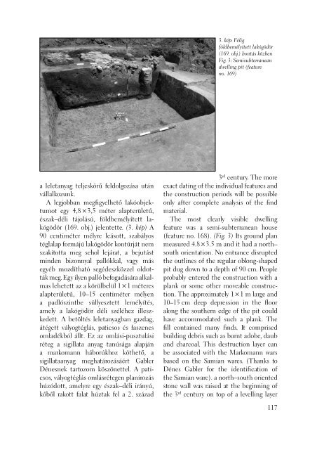
A legjobban megfi gyelhető lakóobjektumot<br />
egy 4,8 × 3,5 méter alapterületű,<br />
észak–déli tájolású, földbemélyített lakógödör<br />
(169. obj.) jelentette. (3. kép) A<br />
90 centiméter mélyre leásott, szabályos<br />
téglalap formájú lakógödör kontúrját nem<br />
szakí totta meg sehol lejárat, a bejutást<br />
minden bizonnyal pallókkal, vagy más<br />
egyéb mozdítható segédeszközzel oldották<br />
meg. Egy ilyen palló befogadására alkalmas<br />
lehetett az a körülbelül 1 × 1 méteres<br />
alapterületű, 10–15 centiméter mélyen<br />
a padlószintbe süllyesztett lemélyítés,<br />
amely a lakógödör déli széléhez illeszkedett.<br />
A betöltés leletanyagban gazdag,<br />
átégett vályogtéglás, paticsos és faszenes<br />
omladékból állt. Ez az omlási-pusztulási<br />
réteg a sigillata anyag tanúsága alapján<br />
a markomann háborúkhoz köthető, a<br />
sigillataanyag meghatározásáért Gabler<br />
Dénesnek tartozom köszönettel. A paticsos,<br />
vályogtéglás omlásrétegen planírozás<br />
húzódott, amelyre egy észak–déli irányú,<br />
kőből rakott falat húztak fel a 2. század<br />
3. kép: Félig<br />
földbemélyített lakógödör<br />
(169. obj.) bontás közben<br />
Fig. 3: Semisubterranean<br />
dwelling pit (feature<br />
no. 169)<br />
3 rd century. The more<br />
exact dating of the individual features and<br />
the construction periods will be possible<br />
only after complete analysis of the fi nd<br />
material.<br />
The most clearly visible dwelling<br />
feature was a semi-subterranean house<br />
(feature no. 168). (Fig. 3) Its ground plan<br />
measured 4.8 × 3.5 m and it had a north–<br />
south orientation. No entrance disrupted<br />
the outlines of the regular oblong-shaped<br />
pit dug down to a depth of 90 cm. People<br />
probably entered the construction with a<br />
plank or some other moveable construction.<br />
The approximately 1 × 1 m large and<br />
10–15 cm deep depression in the fl oor<br />
along the southern edge of the pit could<br />
have accommodated such a plank. The<br />
fi ll contained many fi nds. It comprised<br />
building debris such as burnt adobe, daub<br />
and charcoal. This destruction layer can<br />
be associated with the Markomann wars<br />
based on the Samian wares. (Thanks to<br />
Dénes Gabler for the identifi cation of<br />
the Samian ware). a north–south oriented<br />
stone wall was raised at the beginning of<br />
the 3 rd century on top of a levelling layer<br />
117