

AQUINCUM
AQUINCUM
AQUINCUM

Create successful ePaper yourself
Turn your PDF publications into a flip-book with our unique Google optimized e-Paper software.
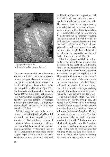
1. kép: Újkori földút részlete<br />
Fig. 1: Detail of an Early Modern dirt-road<br />
felé a mai nyomvonaltól. Nem kivétel ez<br />
alól az a körülbelül 6 méter széles, 60 centiméter<br />
vastagon lekövezett út sem, amit<br />
csak igen keskeny sávban és metszetben<br />
volt lehetőségünk dokumentálni. Utóbbi<br />
utat nyugatról kisebb mesterséges töltés<br />
dombvonulata kísért, aminek a túloldalán<br />
már az 1880-as évekig folytatott szőlőművelés<br />
nyomai voltak dokumentálhatóak; az<br />
egykori tőkék köré összehúzott kupacok<br />
a fi loxéra pusztítása után, és a hegy felől<br />
érkező üledék lerakódása során is épen<br />
maradtak. (2. kép)<br />
Miután meggyőződtünk róla, hogy a<br />
történeti rétegeket jóval mélyebben kell<br />
keresnünk, az árok nyugati szakaszát<br />
lépcsőzetes kialakításban, legmélyebb<br />
pontján a felszíntől számított 3,20 méterig<br />
bontottuk ki, de az altalajt csak egy<br />
keskeny szondában, 3,70 méter mélyen értük<br />
el. A terület modern feltöltése az árok<br />
nyugati végén elérte a 2 métert is, alatta<br />
azonban a természetes üledékréteg csak<br />
92<br />
could be identifi ed with the previous track<br />
of Bécsi Road since their direction was<br />
signifi cantly different (towards the hill).<br />
The same is true of the approximately<br />
6 m wide road with a 60 cm thick pavement,<br />
which could be documented along<br />
a very narrow stripe and in cross-section.<br />
A smaller artifi cial embankment ran along<br />
the western side of this road. Beyond this<br />
bank, traces of vineyards functioning until<br />
the 1880’s could be found. The earth piles<br />
gathered around the former vine-stocks<br />
survived after the phylloxera devastation<br />
and despite the deposition of the soil<br />
eroded down from the hill (Fig. 2).<br />
After it was discovered that the historical<br />
layers lay much deeper, we proceeded<br />
in steps down to a depth of 3.2 m from the<br />
surface in the western part of the trench.<br />
Even so, the the subsoil was reached only<br />
in a narrow test pit at a depth of 3.7 m.<br />
The modern fi ll attained a thickness of 2<br />
m in the western end of the trench, while<br />
the natural sediments could be followed<br />
only until the middle of the western section<br />
of the trench. This layer probably<br />
originally thinned out in a westerly direction<br />
and a larger part of it was destroyed.<br />
The humus layer, which was under<br />
cultivation in the modern period, appeared<br />
to be 50–60 cm thick. It contained<br />
sporadic Roman material, which became<br />
more abundant in the vicinity of the stone<br />
wall unearthed along a length of 17 m at<br />
the western end of the trench. The layer<br />
partly covered the wall and partly accumulated<br />
to its south. A badly worn coin,<br />
which probably dates from the Constantine<br />
dynasty, was found above a collapsed<br />
stretch of the wall. The east-west oriented<br />
wall (Fig. 3) had neither a foundation nor<br />
was it mortared. The repeated mending<br />
and renovation events can be traced in