- Page 1 and 2: AQUINCUM A BTM Aquincumi Múzeumán
- Page 3 and 4: Szerkesztő: Zsidi Paula Fordítás
- Page 5 and 6: Budapesti Történeti Múzeum Aquin
- Page 7 and 8: Régészeti kutatások a Rudas für
- Page 9 and 10: Régészeti feltárások Budapest t
- Page 11 and 12: ház feltárása. Bevásárló köz
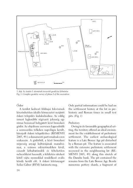
- Page 13: 13. Bp. XI. Fehérvári út 202. (B
- Page 17 and 18: 3. kép. A telek északkeleti rész
- Page 19 and 20: kívül esett a beépített, lakott
- Page 21 and 22: zadra keltezhető római kori plan
- Page 23 and 24: sók és kancsók, a kékmintás po
- Page 25 and 26: Az 1838-as nagy dunai árvíz nyoma
- Page 27 and 28: utcára. A műhelyek vízellátás
- Page 29 and 30: (GESZLER 1984, 420) azonban a rák
- Page 31 and 32: MADARASSY 2000 - Madarassy O.: Rég
- Page 33 and 34: leten kell a hamus-faszenes planír
- Page 35 and 36: 34 3. kép. Agyagtéglafal részlet
- Page 37 and 38: lákból emelt fehérre vakolt ép
- Page 39 and 40: MADARASSY 1998 - Madarassy O. - Ká
- Page 41 and 42: 1. kép: Az ásatási terület hely
- Page 43 and 44: 2. kép: A kőépület déli fala F
- Page 45 and 46: tegula darabok. (4. kép) Belebonto
- Page 47 and 48: Az ásatás téli időpontjából a
- Page 49 and 50: sűrűn épülettörmelékes réteg
- Page 51 and 52: 8. kép: A „B” árkot átszelő
- Page 53 and 54: (Investigations of Early Roman defe
- Page 55 and 56: 1. kép: Az ásatási terület hely
- Page 57 and 58: tőségét azonban jól mutatja, ho
- Page 59 and 60: további, lényegesen ritkább elre
- Page 61 and 62: en hiánytalan. Az emberi maradván
- Page 63 and 64: mutatott. A hét téglasíron kív
- Page 65 and 66:
ásott koponyát pedig az új sírg
- Page 67 and 68:
amely a felmenőfalból származhat
- Page 69 and 70:
A „Peristyl-ház”: hitelesítő
- Page 71 and 72:
folytatódik, az épület déli tra
- Page 73 and 74:
illetve épebb edényrészeket tett
- Page 75 and 76:
arriccio réteg, a hasonló kivitel
- Page 77 and 78:
A „Peristyl-ház” déli traktus
- Page 79 and 80:
megegyezik a kutatásban eddig megj
- Page 81 and 82:
PÓCZY 1955 - Póczy K.: Római ép
- Page 83 and 84:
irányban tovább húzódik. (TOPÁ
- Page 85 and 86:
Munkánk során az Aranyárok és a
- Page 87 and 88:
talajmozgás következtében megsü
- Page 89 and 90:
méteres kőből épített négysz
- Page 91 and 92:
Ezt követően, valószínűleg a 4
- Page 93 and 94:
1. kép: Újkori földút részlete
- Page 95 and 96:
lerakódása valószínűleg össze
- Page 97 and 98:
Régészeti kutatások a Gellérthe
- Page 99 and 100:
5338/3-4 hrsz. beépítetlen telkek
- Page 101 and 102:
hez tartozó ház maradványait tá
- Page 103 and 104:
zelés tette lehetővé. A régész
- Page 105 and 106:
vízvezetékcsövek bolygatták meg
- Page 107 and 108:
kevert föld volt, a sarokmedencék
- Page 109 and 110:
1. kép: Albertfalva, Panel út. Az
- Page 111 and 112:
szintje is magasabban volt megfi gy
- Page 113 and 114:
5. kép: Bronz csatfi bula Fig. 5:
- Page 115 and 116:
Kutatások az albertfalvi auxiliár
- Page 117 and 118:
2. kép: A feltárási terület kel
- Page 119 and 120:
végén, 3. század elején. Ehhez
- Page 121 and 122:
futott. Ennek a kiöblösödő obje
- Page 123 and 124:
Irodalom/References: KOVÁCS 1999 -
- Page 125 and 126:
1. kép. Albertfalva-Kitérő út 2
- Page 127 and 128:
2. kép. A 183. számú objektum á
- Page 129 and 130:
Irodalom/References: ENDRŐDI 1997
- Page 131 and 132:
1. kép: Budapest, XI. Fehérvári
- Page 133 and 134:
3. kép: A 3/1. objektum (árok) é
- Page 135 and 136:
mai kori gödröt (2/3. objektum),
- Page 137 and 138:
HÖCKMANN 1972 - Höckmann, O.: And
- Page 139 and 140:
1. kép: Légifotó az első lakót
- Page 141 and 142:
olit gödröket a vízpart közvetl
- Page 143 and 144:
edény töredékei feküdtek, melye
- Page 145 and 146:
kí vül élt kultúrák leletei fe
- Page 147 and 148:
jes kontinuitást feltételezünk.
- Page 149 and 150:
területén megtalálható volt, b
- Page 151 and 152:
jelenő Somogyvár-Vinkovci edényf
- Page 153 and 154:
itől. (12. kép) Néhol égetőhel
- Page 155 and 156:
izonyítják a helyi szövés megl
- Page 157 and 158:
mellett álltak, máskor pedig a k
- Page 159 and 160:
négyzetes alapterületű földbem
- Page 161 and 162:
ezüst pénze alapján a 12. száza
- Page 163 and 164:
kemencét sikerült feltárnunk, (2
- Page 165 and 166:
der Fundstücke aus den Fürstengr
- Page 167 and 168:
sos sírja Budapesten.) Zalai Múze
- Page 169 and 170:
Paskál lakópark II. építési ü
- Page 171 and 172:
párhuzamosan futó 8-as szelvény
- Page 173 and 174:
valamint a használati tárgy (kőe
- Page 175 and 176:
fejlődéssel együtt kialakuló k
- Page 177 and 178:
HORVÁTH-JUHÁSZ-KÖHLER 2003 - Hor
- Page 179 and 180:
amelynek mértéke többnyire az er
- Page 181 and 182:
tálak. Ugyancsak előkerültek a n
- Page 183 and 184:
fegyverek (vas kardok, lándzsák,
- Page 185 and 186:
feltárása során bukkantunk. A te
- Page 187 and 188:
Régészeti kutatások az M0 körgy
- Page 189 and 190:
Gyár területén 7 zsugorított cs
- Page 191 and 192:
lejtőjén, Rákos-patak egyik mell
- Page 193 and 194:
a jégkorszaki faunával kapcsolato
- Page 195 and 196:
9. kép: BP 05. lh. A protoboleráz
- Page 197 and 198:
Transdanubien. In: Lichardus, J. (H
- Page 199 and 200:
1. kép: Összesítő alaprajz az 1
- Page 201 and 202:
2. kép: A 2004-es feltárás össz
- Page 203 and 204:
fi gyelt objektumcsoportokhoz hason
- Page 205 and 206:
A nagy homokhát legdélebbi rész
- Page 207 and 208:
csukló környékén több rétegbe
- Page 209 and 210:
kultúra települése és a déldun
- Page 211 and 212:
Az Aquincumi Múzeum kisebb feltár
- Page 213 and 214:
Megfi gyeléseink alapján újra cs
- Page 215 and 216:
és csontvázas sír részletét do
- Page 217 and 218:
egymással párhuzamosan fut észak
- Page 219 and 220:
történt megfi gyelés alapján, a
- Page 221 and 222:
étegben helyezkedett el. A terüle
- Page 223 and 224:
13. Budapest, III. ker., Kunigunda
- Page 225 and 226:
0,6 méter széles észak-déli ir
- Page 227 and 228:
irányú lejtés miatt. (8. kép) O
- Page 229 and 230:
alatt tető- és falomladékot fi g
- Page 231 and 232:
maradványok a polgárvárostól d
- Page 233 and 234:
önálló lelőhely mellett, a Duna
- Page 235 and 236:
lelőhelyen. A lekerekített tégla
- Page 237 and 238:
17. Bp. III. Szentendrei Road (Lrn:
- Page 239 and 240:
Az Aquincumi Múzeum további felt
- Page 241 and 242:
Rövidítésjegyzék Abbreviations
- Page 243 and 244:
Hudák Krisztina (BTM Aquincumi Mú
- Page 245 and 246:
A 2004. évi feltárások megbízó
- Page 247 and 248:
PART Ingatlanfejlesztő és Kezelő
- Page 249 and 250:
CHOYKE Alice Osseous Projectile Poi
- Page 251 and 252:
HORVÁTH László András Bemerkung
- Page 253 and 254:
Budapest, III. San Marco utca 6-8.-
- Page 255 and 256:
Budapest, III. Hajógyár-sziget. /
- Page 257:
ZSIDI Paula Aquincum : A BTM Aquinc