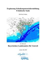
Climate Change and the European Water Dimension - Agri ...
Climate Change and the European Water Dimension - Agri ...
Climate Change and the European Water Dimension - Agri ...

Create successful ePaper yourself
Turn your PDF publications into a flip-book with our unique Google optimized e-Paper software.
It is realized that adaptation to climate change – that is <strong>the</strong> ‘ability ... to adjust to<br />
climate changes (including climate variability <strong>and</strong> extremes) to moderate potential<br />
damages….or to cope with consequences’ (IPCC, 2001) – should be a key issue.<br />
Possible adaptation options can be taken in populated areas that involve <strong>the</strong><br />
planning of settlements <strong>and</strong> <strong>the</strong>ir infrastructure, placement of industrial facilities etc.<br />
in a manner to reduce <strong>the</strong> negative effects of events <strong>and</strong> to forecast <strong>and</strong> minimize<br />
potential damages.<br />
V.A.3. Main expected effects for extreme floods <strong>and</strong> droughts<br />
“(Monthly) Runoff tends to increase in nor<strong>the</strong>rn Europe, <strong>and</strong> decrease in <strong>the</strong> south.<br />
Percentage increases are up to 25% <strong>and</strong> decreases may be as great as 50%”<br />
(Arnell, 1999). “Low flows tend to be reduced in maritime parts of Europe, as summer<br />
flows decline, but may increase (in winter) in more continental parts of Europe” This<br />
is because of a shift of snowfall to rainfall <strong>and</strong> increased snowmelt during winters in<br />
<strong>the</strong>se continental areas, which have now low winter runoff.<br />
“During summer months, Sou<strong>the</strong>rn Europe is expected to become drier while<br />
Nor<strong>the</strong>rn Europe will probably get wetter” (Vellinga <strong>and</strong> Van Verseveld, 2000).<br />
“Flood magnitude <strong>and</strong> frequency are likely (a 66-90% probability) to increase in most<br />
regions, <strong>and</strong> low flows are likely to decrease in many regions” (IPCC-McCarthy et al,<br />
2001).<br />
Palmer <strong>and</strong> Räisänen (2002) find that in <strong>the</strong> winter over Europe, <strong>the</strong> probability of<br />
extremely high seasonal precipitation increases by about two to five times over <strong>the</strong><br />
course of <strong>the</strong> next 50 to 100 years.<br />
Simulations by Schar et al. (2004) suggested that, towards <strong>the</strong> end of this century,<br />
every second summer in Europe could be as hot <strong>and</strong> dry as <strong>the</strong> summer of 2003.<br />
They write: "The <strong>European</strong> summer climate might experience a profound increase in<br />
year-to-year variability in response to greenhouse forcing. Such an increase might be<br />
able to explain <strong>the</strong> unusual <strong>European</strong> summer of 2003, <strong>and</strong> would strongly affect <strong>the</strong><br />
incidence of heatwaves <strong>and</strong> droughts in <strong>the</strong> future."<br />
In addition to <strong>the</strong> direct effects, increased heat stress <strong>and</strong> lower soil moisture<br />
availability will increase <strong>the</strong> dem<strong>and</strong> for water resources in summer, leading higher<br />
rates of water abstraction from stream flows <strong>and</strong> groundwater that in turn might<br />
decrease low flows <strong>and</strong> lower <strong>the</strong> groundwater table.<br />
Known gaps <strong>and</strong> questions<br />
Schnur (2002) stated that today's climate models are not good at predicting extreme<br />
climate events in local areas, such as flooding in a given river basin, because <strong>the</strong>y<br />
are limited in <strong>the</strong>ir resolution to a coarse grid size of about 200 kilometres. For <strong>the</strong><br />
average river basin, climate-change simulations would need a much higher resolution<br />
of tens of kilometres, but this will not be available for quite some time.<br />
Burl<strong>and</strong>o (2004) goes even fur<strong>the</strong>r <strong>and</strong> states that climate change analysis on water<br />
resources needs to be done at <strong>the</strong> catchment scale, preferably at sizes of 1km2 or<br />
even smaller, which is <strong>the</strong> scale where wea<strong>the</strong>r variability <strong>and</strong> l<strong>and</strong>scape variability<br />
reaches manageable proportions.<br />
Until <strong>the</strong>se high-resolution climate change simulations are available, downscaling<br />
methods need to be applied to produce <strong>the</strong> proper spatial resolution needed for<br />
119