

Tulsa Comprehensive Plan - PLANiTULSA
Tulsa Comprehensive Plan - PLANiTULSA
Tulsa Comprehensive Plan - PLANiTULSA

Create successful ePaper yourself
Turn your PDF publications into a flip-book with our unique Google optimized e-Paper software.
Transportation<br />
PArT II: thE roUtE For tULsa<br />
how we Get there: Context<br />
sensitive solutions (Css) approach<br />
Currently <strong>Tulsa</strong> uses a conventional transportation<br />
decision making process which is governed by automobile<br />
travel demand and level of service criteria. In CSS these<br />
are still important criteria, but are balanced with other<br />
context-related criteria including community objectives,<br />
thoroughfare type and the type and intensity of the adjacent<br />
land uses.<br />
CSS will be a vital element to building public-private<br />
partnerships to develop the new centers, multi-modal<br />
corridors, main streets and residential streets articulated in<br />
Our Vision for <strong>Tulsa</strong>. Appendix Transportation I offers a<br />
sample CSS policy and process.<br />
Multi-Modal Street System<br />
The first transportation building block is the multi-modal<br />
street system. A multi-modal street balances the needs of<br />
all modes of travel, giving people the option to walk, bike,<br />
ride transit or drive. The street types include Main Streets,<br />
Multi-Modal Streets, Commuter Streets and Residential<br />
Collector Streets. These street types attempt to strike a<br />
balance between functional classification, adjacent land<br />
use, and the competing travel needs.<br />
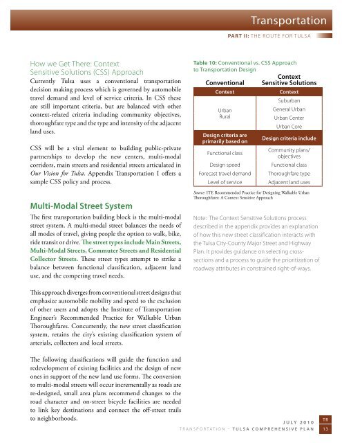
Table 10: Conventional vs. CSS Approach<br />
to Transportation Design<br />
Context<br />
Conventional Sensitive Solutions<br />
Context<br />
Context<br />
suburban<br />
Urban<br />
rural<br />
Design criteria are<br />
primarily based on<br />
Functional class<br />
Design speed<br />
Forecast travel demand<br />
Level of service<br />
General Urban<br />
Urban Center<br />
Urban Core<br />
Design criteria include<br />
Community plans/<br />
objectives<br />
Functional class<br />
thoroughfare type<br />
adjacent land uses<br />
Source: ITE Recommended Practice for Designing Walkable Urban<br />
Thoroughfares: A Context Sensitive Approach<br />
note: the Context sensitive solutions process<br />
described in the appendix provides an explanation<br />
of how this new street classification interacts with<br />
the tulsa City-County Major street and highway<br />
plan. it provides guidance on selecting crosssections<br />
and a process to guide the prioritization of<br />
roadway attributes in constrained right-of-ways.<br />
This approach diverges from conventional street designs that<br />
emphasize automobile mobility and speed to the exclusion<br />
of other users and adopts the Institute of Transportation<br />
Engineer’s Recommended Practice for Walkable Urban<br />
Thoroughfares. Concurrently, the new street classification<br />
system, retains the city’s existing classification system of<br />
arterials, collectors and local streets.<br />
The following classifications will guide the function and<br />
redevelopment of existing facilities and the design of new<br />
ones in support of the new land use forms. The conversion<br />
to multi-modal streets will occur incrementally as roads are<br />
re-designed, small area plans recommend changes to the<br />
road character and on-street bicycle facilities are needed<br />
to link key destinations and connect the off-street trails<br />
to neighborhoods.<br />
July 2010<br />
TR<br />
transportation – <strong>Tulsa</strong> comprehensive plan 13


