Air quality expert group - Fine particulate matter (PM2.5) in ... - Defra
Air quality expert group - Fine particulate matter (PM2.5) in ... - Defra
Air quality expert group - Fine particulate matter (PM2.5) in ... - Defra

You also want an ePaper? Increase the reach of your titles
YUMPU automatically turns print PDFs into web optimized ePapers that Google loves.
<strong>PM2.5</strong> <strong>in</strong> the UK<br />
126<br />
15. Some of the characteristics of local-scale models are summarised <strong>in</strong> A2.8 to<br />
A2.10. All of these models are capable of predict<strong>in</strong>g concentrations down to a<br />
scale of a few metres or so and are driven by <strong>in</strong>ventories on a more local scale,<br />
such as the National Atmospheric Emissions Inventory (NAEI) or the London<br />
Atmospheric Emissions Inventory (LAEI). Unlike the regional models, they do<br />
not attempt to treat explicitly the formation of secondary <strong>particulate</strong> <strong>matter</strong> at<br />
a regional scale but use assumptions based on measurements or the outputs<br />
from other models as boundary conditions. For example, when consider<strong>in</strong>g a<br />
specific urban area, the relatively large regional component and its speciation<br />
are separately estimated and the <strong>in</strong>crement due to explicitly modelled urban<br />
sources added to it. Nevertheless, as shown <strong>in</strong> A2.8 and A2.9, it is possible to<br />
disaggregate the contributions to <strong>PM2.5</strong> to a high level of detail. In addition, the<br />
ADMS-Urban model described <strong>in</strong> A2.10 is capable of produc<strong>in</strong>g both highly<br />
time- and spatially-resolved predictions of <strong>PM2.5</strong> mass (hourly predictions at<br />
a 1 m resolution). Furthermore, these models can provide useful <strong>in</strong>formation<br />
on urban transects, as shown <strong>in</strong> Figure 5.6 which reveals the importance of<br />
the large regional component of <strong>PM2.5</strong>, the overall urban <strong>in</strong>crement and the<br />
importance of <strong>in</strong>dividual roads.<br />
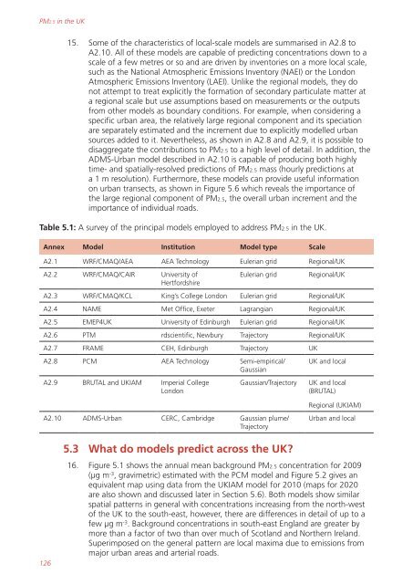
Table 5.1: A survey of the pr<strong>in</strong>cipal models employed to address <strong>PM2.5</strong> <strong>in</strong> the UK.<br />
Annex Model Institution Model type Scale<br />
A2.1 WRF/CMAQ/AEA AEA Technology Eulerian grid Regional/UK<br />
A2.2 WRF/CMAQ/CAIR University of<br />
Hertfordshire<br />
Eulerian grid Regional/UK<br />
A2.3 WRF/CMAQ/KCL K<strong>in</strong>g’s College London Eulerian grid Regional/UK<br />
A2.4 NAME Met Office, Exeter Lagrangian Regional/UK<br />
A2.5 EMEP4UK University of Ed<strong>in</strong>burgh Eulerian grid Regional/UK<br />
A2.6 PTM rdscientific, Newbury Trajectory Regional/UK<br />
A2.7 FRAME CEH, Ed<strong>in</strong>burgh Trajectory UK<br />
A2.8 PCM AEA Technology Semi-empirical/<br />
Gaussian<br />
A2.9 BRUTAL and UKIAM Imperial College<br />
London<br />
A2.10 ADMS-Urban CERC, Cambridge Gaussian plume/<br />
Trajectory<br />
5.3 What do models predict across the UK?<br />
UK and local<br />
Gaussian/Trajectory UK and local<br />
(BRUTAL)<br />
Regional (UKIAM)<br />
Urban and local<br />
16. Figure 5.1 shows the annual mean background <strong>PM2.5</strong> concentration for 2009<br />
(µg m -3 , gravimetric) estimated with the PCM model and Figure 5.2 gives an<br />
equivalent map us<strong>in</strong>g data from the UKIAM model for 2010 (maps for 2020<br />
are also shown and discussed later <strong>in</strong> Section 5.6). Both models show similar<br />
spatial patterns <strong>in</strong> general with concentrations <strong>in</strong>creas<strong>in</strong>g from the north-west<br />
of the UK to the south-east, however, there are differences <strong>in</strong> detail of up to a<br />
few µg m -3 . Background concentrations <strong>in</strong> south-east England are greater by<br />
more than a factor of two than over much of Scotland and Northern Ireland.<br />
Superimposed on the general pattern are local maxima due to emissions from<br />
major urban areas and arterial roads.