Download - Academy Publisher
Download - Academy Publisher
Download - Academy Publisher

Create successful ePaper yourself
Turn your PDF publications into a flip-book with our unique Google optimized e-Paper software.
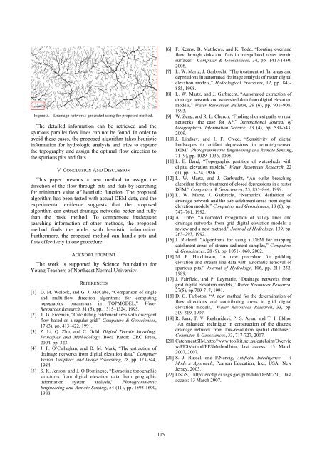
Figure 3. Drainage networks generated using the proposed method.<br />
The detailed information can be retrieved and the<br />
spurious parallel flow lines can not be found. In order to<br />
avoid these cases, the proposed algorithm takes heuristic<br />
information for hydrologic analysis and tries to capture<br />
the topography and assign the optimal flow direction to<br />
the spurious pits and flats.<br />
V CONCLUSION AND DISCUSSION<br />
This paper presents a new method to assign the<br />
direction of the flow through pits and flats by searching<br />
for minimum value of heuristic function. The proposed<br />
algorithm has been tested with actual DEM data, and the<br />
experimental evidence suggests that the proposed<br />
algorithm can extract drainage networks better and fully<br />
than the basic method. To compensate inadequate<br />
searching information of other methods, the proposed<br />
method finds the outlet with heuristic information.<br />
Furthermore, the proposed method can handle pits and<br />
flats effectively in one procedure.<br />
ACKNOWLEDGMENT<br />
The work is supported by Science Foundation for<br />
Young Teachers of Northeast Normal University.<br />
REFERENCES<br />
[1] D. M. Wolock, and G. J. McCabe, “Comparison of single<br />
and multi-flow direction algorithms for computing<br />
topographic parameters in TOPMODEL,” Water<br />
Resources Research, 31 (5), pp. 1315–1324, 1995.<br />
[2] T. G. Freeman, “Calculating catchment area with divergent<br />
flow based on a regular grid,” Computers & Geosciences,<br />
17 (3), pp. 413–422, 1991.<br />
[3] Z. Li, Q. Zhu, and C. Gold, Digital Terrain Modeling:<br />
Principles and Methodology, Boca Raton: CRC Press,<br />
2004, pp. 323.<br />
[4] J. F. O’Callaghan, and D. M. Mark, “The extraction of<br />
drainage networks from digital elevation data,” Computer<br />
Vision, Graphics, and Image Processing, 28, pp. 323-344,<br />
1984.<br />
[5] S. K. Jenson, and J. O Domingue, “Extracting topographic<br />
structures from digital elevation data from geographic<br />
information system analysis,” Photogrammetric<br />
Engineering and Remote Sensing, 54 (11), pp. 1593-1600,<br />
1988.<br />
[6] F. Kenny, B. Matthews, and K. Todd, “Routing overland<br />
flow through sinks and flats in interpolated raster terrain<br />
surfaces,” Computer & Geosciences, 34, pp. 1417-1430,<br />
2008.<br />
[7] L. W. Martz, J. Garbrecht, “The treatment of flat areas and<br />
depressions in automated drainage analysis of raster digital<br />
elevation models,” Hydrological Processes, 12, pp. 843-<br />
855, 1998.<br />
[8] L. W. Martz, and J. Garbrecht, “Automated extraction of<br />
drainage network and watershed data from digital elevation<br />
models,” Water Resources Bulletin, 29 (6), pp. 901–908,<br />
1993.<br />
[9] W. Zeng, and R. L. Church, “Finding shortest paths on real<br />
networks: the case for A*,” International Journal of<br />
Geographical Information Science, 23 (4), pp. 531-543,<br />
2009.<br />
[10] J. Lindsay, and I. F. Creed, “Sensitivity of digital<br />
landscapes to artifact depressions in remotely-sensed<br />
DEM,” Photogrammetric Engineering and Remote Sensing,<br />
71 (9), pp. 1029–1036, 2005.<br />
[11] L. E. Band, “Topographic partition of watersheds with<br />
digital elevation models,” Water Resources Research, 22<br />
(1), pp. 15–24, 1986.<br />
[12] L. W. Martz, and J. Garbrecht, “An outlet breaching<br />
algorithm for the treatment of closed depressions in a raster<br />
DEM,” Computers & Geosciences, 25, 835–844, 1999.<br />
[13] L. W. Martz, J. Garbrecht, “Numerical definition of<br />
drainage network and the sub-catchment areas from digital<br />
elevation models,” Computers and Geosciences, 18 (6), pp.<br />
747–761, 1992.<br />
[14] A. Tribe, “Automated recognition of valley lines and<br />
drainage networks from grid digital elevation models: a<br />
review and a new method,” Journal of Hydrology, 139, pp.<br />
263–293, 1992.<br />
[15] J. Richard, “Algorithms for using a DEM for mapping<br />
catchment areas of stream sediment samples,” Computers<br />
& Geosciences, 28 (9), pp. 1051-1060, 2002.<br />
[16] M. F. Hutchinson, “A new procedure for gridding<br />
elevation and stream line data with automatic removal of<br />
spurious pits,” Journal of Hydrology, 106, pp. 211–232,<br />
1989.<br />
[17] J. Fairfield, and P. Leymarie, “Drainage networks from<br />
grid digital elevation models,” Water Resources Research,<br />
27(5), pp.709-717, 1991.<br />
[18] D. G. Tarboton, “A new method for the determination of<br />
flow directions and contributing areas in grid digital<br />
elevation models,” Water Resources Research, 33, pp.<br />
309-319, 1997.<br />
[19] R. Jana, T. V. Reshmidevi, P. S. Arun, and T. I. Eldho,<br />
“An enhanced technique in construction of the discrete<br />
drainage network from low-resolution spatial database,”<br />
Computer & Geosciences, 33, 717-727, 2007.<br />
[20] CatchmentSIM,http://www.toolkit.net.au/catchsim/Overvie<br />
w/PFSMethod/PFSMethod.htm, last access: 13 March<br />
2007, 2007.<br />
[21] S. J. Russel, and P.Norvig, Artificial Intelligence – A<br />
Modern Approach, Pearson Education, Inc., USA: New<br />
Jersey, 2003.<br />
[22] USGS, http://edcftp.cr.usgs.gov/pub/data/DEM/250, last<br />
access: 13 March 2007.<br />
115