Download - Academy Publisher
Download - Academy Publisher
Download - Academy Publisher

Create successful ePaper yourself
Turn your PDF publications into a flip-book with our unique Google optimized e-Paper software.
provide such data, without the need for real-time resampling.<br />
That is advantages of pyramid model. If there<br />
is no pyramid model, it is necessary to real-time<br />
simplified based on the original terrain data and image<br />
data for achieving the level of detail results. Despite an<br />
increase the data storage space, the pyramid model can<br />
reduce the time in mapping and speed up the rendering of<br />
the scene.<br />
B. Pyramid-based Texture Mapping<br />
In 3D terrain visualization, the true reflection of the<br />
terrain is an important part. Texture mapping is a major<br />
technology to increase the authenticity. The Ground<br />
Remote sensing image is a real record on ground floor<br />
landscape; it contains a rich mount of information.<br />
Therefore, take remote sensing image as texture image,<br />
through texture mapping; 3D terrain model can have a<br />
richer information and realism.<br />
Texture mapping used in this paper, is a method which<br />
is used in multi-resolution terrain LOD simplification.<br />
Firstly, for the texture, establish a quadtree-based<br />
pyramid and texture tree. Because the terrain geometry<br />
and textures use in the same pyramid model, in real-time<br />
terrain rendering, the appropriate resolution texture is<br />
selected from the texture tree according the details of<br />
terrain levels.<br />
The terrain geometry and texture use in the same<br />
pyramid model. When rendering the terrain geometry, in<br />
accordance with corresponding relation, finding the<br />
corresponding block, and then by way of texture of<br />
texture mapping, the remote sensing image pictures was<br />
draw to the terrain, thus increasing the real effect of the<br />
terrain.<br />
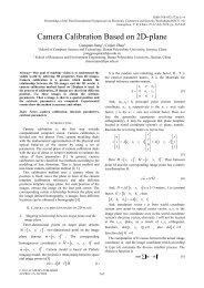
Ⅲ. VISUALIZATION OF VECTOR DATA IN 3D TRRRAIN<br />
The basic idea that vector data visualized in 3D terrain<br />
is, reading the vector data, raster 2D vector data into<br />
texture image, and then using the standard texture<br />
mapping method to draw, so the vector data can be draw<br />
out in 3D terrain.<br />
The 3D terrain visualization needs two kinds of data,<br />
geometric terrain data (DEM) and surface remote sensing<br />
image (DOM). Which are organized in the external<br />
device in the form of layer and sub-block. But in this<br />
paper, pyramid model was used which based on Quadtree.<br />
The vector data take as whole, recorded regional<br />
geographic information, not organized in the form of<br />
block. Vector data can be visualized in 3D terrain by<br />
raster into the form of texture. Texture block vector data<br />
is composed of two parts: remote sensing image subblock<br />
data, the vector data in the same region. As<br />
showing in the Fig. 2, the terrain geometry and textures<br />
use in the same pyramid model. When rendering to a<br />
block of terrain geometry, according the corresponding<br />
relation to find the corresponding block, and calculate to<br />
get the location information that the remote sensing<br />
image block represent, which according the pyramid tree,<br />
and then read the vector data obtained in the region.<br />
Using the render-to-texture, rendering the vector data to<br />
remote sensing image block, and attributes of vector data<br />
Figure 2. The schematic of vector data visualized in 3D terrain<br />
such as color 、 fill-color, need to be determined in<br />
advance of drawing vector texture mapping. So the new<br />
remote-sensing texture block that obtain vector data was<br />
got, which called “vector texture block”. Then the<br />
ordinary texture mapping, texture mapping to the<br />
topography of the block, making the three-dimensional<br />
terrain rendered on vector data. As the vector data have<br />
been drawn to the texture, therefore, the vector data can<br />
be up and down with the terrain raising and falling.<br />
Ⅳ. THE KEY TECHNOLOGY OF REAL-TIME RENDERING<br />
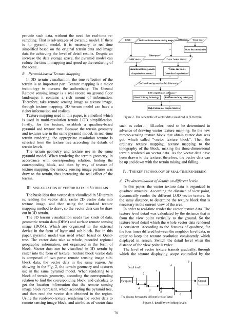
A. The determination of details on different levels.<br />
In this paper, the vector texture data is organized in<br />
quadtree structure. According the distance of view point,<br />
dynamically render the different LOD vector texture. In<br />
the same distance, to determine the texture block that is<br />
necessary in the current view of the area.<br />
In order to real-time render the vector texture data. The<br />
texture level detail was calculated by the distance that is<br />
from the view point vertically to the ground. So the<br />
texture level detail which the whole vector data rendered<br />
is consistent. According to the features of quadtree, for<br />
the four times differed between the neighbor level data, in<br />
order to keep the texture resolution consistently which<br />
displayed in screen. Switch the detail level when the<br />
distance of the view point is twice.<br />
The level of vector texture transits gradually, through<br />
which the texture displaying scope controlled by the<br />
1<br />
Viewpoint<br />
Detail level L<br />
d<br />
2<br />
The distance between the different levels of detail<br />
d<br />
3<br />
d<br />
Figure 3. detail by switching levels<br />
4<br />
d<br />
5<br />
Ground<br />
78