Download - Academy Publisher
Download - Academy Publisher
Download - Academy Publisher

Create successful ePaper yourself
Turn your PDF publications into a flip-book with our unique Google optimized e-Paper software.
ISBN 978-952-5726-09-1 (Print)<br />
Proceedings of the Second International Symposium on Networking and Network Security (ISNNS ’10)<br />
Jinggangshan, P. R. China, 2-4, April. 2010, pp. 077-080<br />
Research and Implementation the Real Time<br />
Rendering and Integration Of Vector Data with<br />
3D Terrain<br />
Meiyu Zhang 1 , Yu Li 2 , and Qi Hu 2<br />
1<br />
Computer science and technology College, Zhejiang University of Technology, Hangzhou, China<br />
Email: zmy@zjut.edu.cn<br />
2<br />
Computer science and technology College, Zhejiang University of Technology, Hangzhou, China<br />
Email:popliyu@gmail.com, 278927305@qq.com<br />
Abstract—In 3D scene, introducing the Vector Data, will be<br />
enable 3D Terrain with spatial analysis capabilities, And<br />
vector data can make up for deficiencies in the performance<br />
of 3D terrain data. This paper focuses on the integration,<br />
real-time rendering of 2D vector data and 3D terrain.<br />
Texture-based means is used to implement vector data<br />
mapping in 3D terrain, which can basically meet the<br />
requirements of real-time rendering of 3D terrain and the<br />
vector data are well display in 3D terrain.<br />
Index Terms—Vector data; 3D terrain; Integration; Realtime<br />
rendering<br />
I. INTRODUCTION<br />
Currently 2D GIS information system has developed<br />
well, but because the GIS information system has<br />
instructiveness in performance the geographic<br />
information. It is required for the geographical<br />
information gradually increasing, with the emergence of<br />
2D GIS, people are more inclined to use 3d GIS, since the<br />
current 3D geographical information development is still<br />
not mature, the standard 3D data structure has not come<br />
up, presently the display of 3D GIS mainly through DEM.<br />
So there is lack of spatial analysis capabilities. In the case<br />
of immature of 3D GIS development, people prefer using<br />
a hybrid data structure, even though, the use of twodimensional<br />
vector data and three-dimensional DEM data<br />
to construct three-dimensional mixed geographic<br />
information system, which makes the system has a strong<br />
spatial analysis capabilities, and performance of 3D GIS<br />
is better. Using the hybrid data structure, a question need<br />
to take consider, which is that how to make the 2D vector<br />
data 3D geographic information data integrate effectively.<br />
In this paper the main work is Researching on this<br />
technology, and solves the problem very well.<br />
II. KEY TECHNOLOGY IN 3D TERRAIN VISUALIZATION<br />
A. Terrain Simplification Technique<br />
Because the data of terrain is massive and the restrict<br />
of current display hardware conditions, it is impossible to<br />
render such a large triangle in interactive speed.<br />
Therefore, the simplification of geometric model and the<br />
representation of multi-resolution has become hot .the<br />
simplification of digital terrain can speed up the<br />
rendering in virtual environments, which make 3D realtime<br />
visualization possible.<br />
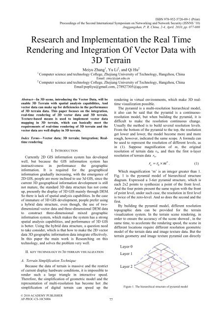
The pyramid is a multi-resolution hierarchical model,<br />
it also can be said that the pyramid is a continuousresolution<br />
model, but when building the pyramid, it is<br />
difficult to make the resolution continuous change.<br />
Usually the method is to build several resolution levels.<br />
From the bottom of the pyramid to the top, the resolution<br />
get lower and lower, the model become more and more<br />
rough, however, indicated the same scope. A formula can<br />
be used to represent the resolution of different levels, as<br />
in (1). Suppose magnification of m, the original<br />
resolution of terrain data r 0 , and then the first n-layer<br />
resolution of terrain data r n .<br />
Layer 0<br />
Layer 1<br />
Layer 2<br />
r r m<br />
n<br />
n<br />
=<br />
0<br />
× . (1)<br />
Which magnification ‘m’ is an integer greater than 1.<br />
Fig. 1 is the pyramid model of hierarchical structure<br />
diagram. Expressed a 3-tier pyramid structure, which is<br />
each 2x2 points to synthesize a point of the front level.<br />
And the four points present the same region with the front<br />
of point level, under such case, the resolution in first level<br />
is twice of the zero-level. And so does the second and the<br />
first.<br />
By building the pyramid model, different resolution<br />
topographic data can be provided for the terrain<br />
visualization system. In the terrain scene rendering, in<br />
order to ensure the accuracy of the scene showed , in the<br />
same time, to accelerate the rendering speed, the scene in<br />
different locations require different resolution geometric<br />
model of the terrain data and image texture data. But the<br />
terrain geometry and image texture pyramid can directly<br />
Figure 1. The hierarchical structure of pyramid model<br />
© 2010 ACADEMY PUBLISHER<br />
AP-PROC-CS-10CN006<br />
77