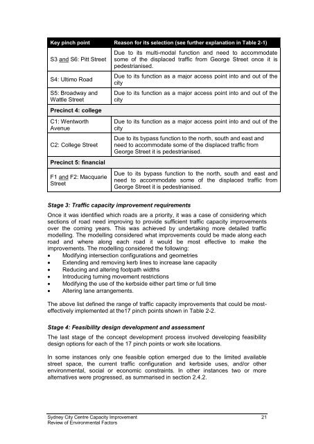
- Page 1 and 2: Sydney City Centre Capacity Improve
- Page 3 and 4: Executive summary The proposal Road
- Page 5 and 6: the proposed Sydney City Centre Cyc
- Page 7 and 8: The REF concludes that the proposal
- Page 9 and 10: Effect Affected factors/receivers L
- Page 11 and 12: Effect Temporary light spill impact
- Page 13 and 14: maintenance of traffic flows in the
- Page 15 and 16: What happens next? Following the su
- Page 17 and 18: 6.7 Water quality and hydrology ...
- Page 19 and 20: If approved, the proposal would tak
- Page 21 and 22: Sydney City Centre Capacity Improve
- Page 23 and 24: In doing so, the REF helps fulfil t
- Page 25 and 26: 2 Need and options considered This
- Page 27 and 28: NSW Long Term Transport Master Plan
- Page 29 and 30: 2.2 Existing road and public transp
- Page 31 and 32: Road Sussex Street between King Str
- Page 33 and 34: Road Precinct 4: college Wentworth
- Page 35 and 36: Bus stop hubs located at Circular Q
- Page 37: With these allocations set, Transpo
- Page 41 and 42: Precinct 2: retail Precinct 2: reta
- Page 43 and 44: Sydney City Centre Capacity Improve
- Page 45 and 46: Precinct 3: southern Precinct 3: so
- Page 47 and 48: Sydney City Centre Capacity Improve
- Page 49 and 50: Precinct 4: college Precinct 4: col
- Page 51 and 52: Sydney City Centre Capacity Improve
- Page 53 and 54: NW2: King Street (two options) Traf
- Page 55 and 56: Amenity All three options reallocat
- Page 57 and 58: Amenity At present, buses cannot re
- Page 59 and 60: Summary Table 2-6 ‘Option b’ an
- Page 61 and 62: Amenity Kerbside use Business impac
- Page 63 and 64: Table 2-7 Analysis of options in pr
- Page 65 and 66: Amenity Kerbside use Business impac
- Page 67 and 68: 3 Description of the proposal The p
- Page 69 and 70: Work site reference Section Start a
- Page 71 and 72: Table 3-2 Typical traffic capacity
- Page 73 and 74: Typical improvement (with example)
- Page 75 and 76: Typical improvement (with example)
- Page 77 and 78: Typical improvement (with example)
- Page 79 and 80: Sussex Street to Kent Street Sussex
- Page 81 and 82: George Street to Pitt Street York S
- Page 83 and 84: Sydney City Centre Capacity Improve
- Page 85 and 86: Sydney City Centre Capacity Improve
- Page 87 and 88: Sydney City Centre Capacity Improve
- Page 89 and 90:
Kent Street intersection Pitt Stree
- Page 91 and 92:
Pitt Street to Castlereagh Street G
- Page 93 and 94:
Margaret Street to Erskine Street J
- Page 95 and 96:
Market Street intersection King Str
- Page 97 and 98:
Sydney City Centre Capacity Improve
- Page 99 and 100:
Sydney City Centre Capacity Improve
- Page 101 and 102:
Sydney City Centre Capacity Improve
- Page 103 and 104:
Sydney City Centre Capacity Improve
- Page 105 and 106:
Sydney City Centre Capacity Improve
- Page 107 and 108:
Sydney City Centre Capacity Improve
- Page 109 and 110:
Liverpool Street to Eager Lane Jame
- Page 111 and 112:
Hay Street to Rawson Place Goulburn
- Page 113 and 114:
Abercrombie Street intersection Ref
- Page 115 and 116:
Ref (refer Fig 3-10 to 3-16) Propos
- Page 117 and 118:
Sydney City Centre Capacity Improve
- Page 119 and 120:
Sydney City Centre Capacity Improve
- Page 121 and 122:
Sydney City Centre Capacity Improve
- Page 123 and 124:
Sydney City Centre Capacity Improve
- Page 125 and 126:
Sydney City Centre Capacity Improve
- Page 127 and 128:
Wemyss Lane to Goulburn Street Ref
- Page 129 and 130:
Macquarie Street intersection Campb
- Page 131 and 132:
Park Street to Oxford Street Prince
- Page 133 and 134:
Sydney City Centre Capacity Improve
- Page 135 and 136:
Sydney City Centre Capacity Improve
- Page 137 and 138:
Sydney City Centre Capacity Improve
- Page 139 and 140:
Sydney City Centre Capacity Improve
- Page 141 and 142:
Sydney City Centre Capacity Improve
- Page 143 and 144:
Sydney City Centre Capacity Improve
- Page 145 and 146:
3.2 Design The proposal’s concept
- Page 147 and 148:
Table 3-9 Engineering and developme
- Page 149 and 150:
3.3 Construction activities The lik
- Page 151 and 152:
Table 3-10 Plant and equipment - in
- Page 153 and 154:
These materials are widely availabl
- Page 155 and 156:
Once the work is complete on site,
- Page 157 and 158:
3.6 Public utility and drainage adj
- Page 159 and 160:
Traffic capacity improvement Precin
- Page 161 and 162:
Traffic capacity improvement Locati
- Page 163 and 164:
4.1.3 Darling Harbour Development P
- Page 165 and 166:
Sydney City Centre Capacity Improve
- Page 167 and 168:
The adopted urban design principles
- Page 169 and 170:
Principles and objectives Consisten
- Page 171 and 172:
Principles and objectives Prot
- Page 173 and 174:
Sydney City Centre Capacity Improve
- Page 175 and 176:
Sydney City Centre Capacity Improve
- Page 177 and 178:
Roads and Maritime is, however, req
- Page 179 and 180:
The one adverse outcome to deliveri
- Page 181 and 182:
5.1.2 Stakeholder engagement Roads
- Page 183 and 184:
The detailed design would also be d
- Page 185 and 186:
Traffic modelling and monitoring da
- Page 187 and 188:
Bus infrastructure There is an exte
- Page 189 and 190:
Cars, buses and other vehicles Over
- Page 191 and 192:
Level of Service (LoS) Maximum queu
- Page 193 and 194:
Work site location Precinct 4: coll
- Page 195 and 196:
Section G: York Street intersection
- Page 197 and 198:
Section Precinct 4: college C1: Wen
- Page 199 and 200:
Location and type of work (refer to
- Page 201 and 202:
with the proposed changes under the
- Page 203 and 204:
Loading zones Mobility parking spac
- Page 205 and 206:
Table 6-8 describes the temporary o
- Page 207 and 208:
Location J: George Street to Pitt S
- Page 209 and 210:
Location H: Hay Street to Rawson Pl
- Page 211 and 212:
As can be seen from Table 6-8, ther
- Page 213 and 214:
Table 6-9 Altered footpaths and ped
- Page 215 and 216:
Section D: Abercrombie Street inter
- Page 217 and 218:
Loading zones Mobility parking spac
- Page 219 and 220:
Table F-2 in Appendix F provides fu
- Page 221 and 222:
Level of Service (LoS) Maximum queu
- Page 223 and 224:
The above table demonstrates the va
- Page 225 and 226:
Impact Environmental safeguard Resp
- Page 227 and 228:
Sydney City Centre Capacity Improve
- Page 229 and 230:
Table 6-13 Construction noise manag
- Page 231 and 232:
The applicable human comfort vibrat
- Page 233 and 234:
where the corresponding noise impac
- Page 235 and 236:
The modelling predicted the constru
- Page 237 and 238:
Work site Receiver type NML for the
- Page 239 and 240:
Work site Receiver type NML for the
- Page 241 and 242:
The highest predicted noise impacts
- Page 243 and 244:
Work site Precinct 3: southern Pred
- Page 245 and 246:
Impact Environmental safeguard Resp
- Page 247 and 248:
Impact Environmental safeguard Resp
- Page 249 and 250:
Post World War II, Sydney enhanced
- Page 251 and 252:
Sydney City Centre Capacity Improve
- Page 253 and 254:
Sydney City Centre Capacity Improve
- Page 255 and 256:
Table 6-21 Heritage listed items It
- Page 257 and 258:
Item name Section Location Signific
- Page 259 and 260:
Item name Section Location Signific
- Page 261 and 262:
Item name Area of archaeology poten
- Page 263 and 264:
Item name 21 Former value and item
- Page 265 and 266:
Item name Works with potential heri
- Page 267 and 268:
Item name R2 Market Street Works wi
- Page 269 and 270:
Item name 3 Pinnacle House 5 Commer
- Page 271 and 272:
Item name Precinct 3: southern S3:
- Page 273 and 274:
Item name Works with potential heri
- Page 275 and 276:
Item name Works with potential heri
- Page 277 and 278:
Item name F2: Macquarie Street Work
- Page 279 and 280:
Lighting pole relocation General si
- Page 281 and 282:
Reference Potential archaeological
- Page 283 and 284:
Reference Potential archaeological
- Page 285 and 286:
Reference Potential archaeological
- Page 287 and 288:
The above summary reflects that the
- Page 289 and 290:
Impact Environmental safeguard Resp
- Page 291 and 292:
6.4.2 Existing environment Populati
- Page 293 and 294:
Social infrastructure Cultural and
- Page 295 and 296:
Sydney City Centre Capacity Improve
- Page 297 and 298:
Sydney City Centre Capacity Improve
- Page 299 and 300:
Sydney City Centre Capacity Improve
- Page 301 and 302:
Social infrastructure - constructio
- Page 303 and 304:
Table 6-27 Annual events potentiall
- Page 305 and 306:
Table 6-28 Location specific potent
- Page 307 and 308:
Work site Construction activities I
- Page 309 and 310:
Work site Construction activities I
- Page 311 and 312:
Work site Construction activities I
- Page 313 and 314:
Work site Construction activities I
- Page 315 and 316:
Work site Construction activities I
- Page 317 and 318:
Work site Construction activities I
- Page 319 and 320:
Work site Construction activities I
- Page 321 and 322:
Socioeconomic impacts during operat
- Page 323 and 324:
The improvements to connectivity an
- Page 325 and 326:
Work site D: Kent Street to Clarenc
- Page 327 and 328:
Work site D: Clarence Street to Yor
- Page 329 and 330:
Work site F: Erskine Street to Barr
- Page 331 and 332:
Work site F: Liverpool Street to Ea
- Page 333 and 334:
Work site C: Wattle Street intersec
- Page 335 and 336:
Work site D: Wemyss Lane to Goulbur
- Page 337 and 338:
Work site F: Park Street to Oxford
- Page 339 and 340:
Method and assessment criteria The
- Page 341 and 342:
General land use character General
- Page 343 and 344:
Development precinct Precinct 1: re
- Page 345 and 346:
Property Roadside property Table 6-
- Page 347 and 348:
Future land uses and development pr
- Page 349 and 350:
Rubbish bins Water fountains City m
- Page 351 and 352:
Impact Environmental safeguard Resp
- Page 353 and 354:
6.6.2 Existing environment Landscap
- Page 355 and 356:
Landscape character zone Overview d
- Page 357 and 358:
Tree characteristics The city centr
- Page 359 and 360:
Table 6-41 Registered significant t
- Page 361 and 362:
· Cafés, restaurants, hotels and
- Page 363 and 364:
Location Receiver * Items marked wi
- Page 365 and 366:
Table 6-43 Temporary construction l
- Page 367 and 368:
Work site Section Receiver F1: Macq
- Page 369 and 370:
Landscape character and visual impa
- Page 371 and 372:
The tree’s consistency and contri
- Page 373 and 374:
Table 6-46 Tree pruning and removal
- Page 375 and 376:
Turning restrictions and provisions
- Page 377 and 378:
Work site Section Visual receiver R
- Page 379 and 380:
Impact Environmental safeguard Resp
- Page 381 and 382:
Impact Environmental safeguard Resp
- Page 383 and 384:
Despite this, Sydney Harbour suppor
- Page 385 and 386:
The proposal footprint is located a
- Page 387 and 388:
Flood risk The proposal footprint h
- Page 389 and 390:
Impact Environmental safeguard Resp
- Page 391 and 392:
to contamination or the generation
- Page 393 and 394:
Acid sulphate soils Acid sulphate s
- Page 395 and 396:
Contaminated land (records) No site
- Page 397 and 398:
Geology and soil impacts during ope
- Page 399 and 400:
Biodiversity Guidelines: Protecting
- Page 401 and 402:
Table 6-56 Statutorily protected bi
- Page 403 and 404:
Impact Environmental safeguard Resp
- Page 405 and 406:
6.10.2 Potential impacts Waste gene
- Page 407 and 408:
In addition, the contractor(s) woul
- Page 409 and 410:
Impact Environmental safeguard Resp
- Page 411 and 412:
6.11.4 Safeguards and management me
- Page 413 and 414:
Affected roads There are no screeni
- Page 415 and 416:
Air quality sensitive receivers The
- Page 417 and 418:
the roads covered by the proposal f
- Page 419 and 420:
Greenhouse Gas Assessment Workbook
- Page 421 and 422:
Climate change construction impacts
- Page 423 and 424:
6.14 Hazard and risk This section a
- Page 425 and 426:
Hazard Potential consequence Key se
- Page 427 and 428:
Impact Environmental safeguard Resp
- Page 429 and 430:
6.15.2 Other committed and/or appro
- Page 431 and 432:
Project Description Location and in
- Page 433 and 434:
Project Description Location and in
- Page 435 and 436:
Table 6-68 Potential cumulative imp
- Page 437 and 438:
Cumulative effect Disruption to pub
- Page 439 and 440:
Cumulative effect Key issues
- Page 441 and 442:
Cumulative effect Key issues Street
- Page 443 and 444:
Table 6-69 Potential cumulative eff
- Page 445 and 446:
6.15.4 Safeguards and management me
- Page 447 and 448:
Effect Affected factors/receivers L
- Page 449 and 450:
Effect Affected factors/receivers L
- Page 451 and 452:
7 Environmental management This cha
- Page 453 and 454:
No Impact Environmental safeguard R
- Page 455 and 456:
No Impact Environmental safeguard R
- Page 457 and 458:
No Impact Environmental safeguard R
- Page 459 and 460:
No Impact Environmental safeguard R
- Page 461 and 462:
No Impact Environmental safeguard R
- Page 463 and 464:
No Impact Environmental safeguard R
- Page 465 and 466:
No Impact Environmental safeguard R
- Page 467 and 468:
No Impact Environmental safeguard R
- Page 469 and 470:
No Impact Environmental safeguard R
- Page 471 and 472:
No Impact Environmental safeguard R
- Page 473 and 474:
No Impact Environmental safeguard R
- Page 475 and 476:
No Impact Environmental safeguard R
- Page 477 and 478:
No Impact Environmental safeguard R
- Page 479 and 480:
8 Conclusion This chapter provides
- Page 481 and 482:
Object environment. 5(a)(ii) To enc
- Page 483 and 484:
8.3 Ecologically sustainable develo
- Page 485 and 486:
8.3.4 Improved valuation, pricing a
- Page 487 and 488:
9 Certification This review of envi
- Page 489 and 490:
City of Sydney Council, Sydney City
- Page 491 and 492:
NSW EPA 1997c, Waste Reduction and
- Page 493 and 494:
factors-june-2014.pdf, accessed: 2/
- Page 495:
ISEPP State Environmental Planning


