Il fiume Fortore - Studi preliminari al piano di gestione dei SIC
Il fiume Fortore - Studi preliminari al piano di gestione dei SIC
Il fiume Fortore - Studi preliminari al piano di gestione dei SIC

Create successful ePaper yourself
Turn your PDF publications into a flip-book with our unique Google optimized e-Paper software.
An t o n e l l a De Iuliiis<br />
INQUADRAMENTO SOCIOECONOMICO<br />
della <strong>di</strong>soccupazione, esodo <strong>dei</strong> residenti soprattutto<br />
delle fasce giovanili, riduzione <strong>dei</strong> caratteri <strong>di</strong> coesione<br />
delle comunità loc<strong>al</strong>i), mentre specularmene si evidenziano<br />
risorse ed opportunità per attrezzare e rendere<br />
sostenibile una strategia <strong>di</strong> rilancio e <strong>di</strong> sviluppo: presenza<br />
<strong>di</strong> risorse e patrimoni a volte ancora intatti e in<br />
grado <strong>di</strong> essere ottimizzati in una logica <strong>di</strong> sviluppo; un<br />
assetto territori<strong>al</strong>e e un paesaggio rur<strong>al</strong>e ancora in<strong>al</strong>terati<br />
e v<strong>al</strong>orizzabili sul <strong>piano</strong> attrattivo; un sistema <strong>di</strong><br />
piccoli centri storici con <strong>di</strong>ffuse qu<strong>al</strong>ità urbanistiche e<br />
architettoniche e una cultura <strong>di</strong> comunità ancora <strong>di</strong>ffusa<br />
e pregnante che potrebbe costituire il perno sul<br />
qu<strong>al</strong>e promuovere un modello <strong>di</strong> ospit<strong>al</strong>ità <strong>al</strong>ternativo<br />
ed innovativo.<br />
Parimenti si evidenziano le seguenti tendenze e prospettive:<br />
• il recupero ed il ripopolamento, anche a fini<br />
<strong>di</strong> servizio, <strong>dei</strong> centri storici e la v<strong>al</strong>orizzazione<br />
del paesaggio rur<strong>al</strong>e costituiscono una variabile<br />
strategica sulla qu<strong>al</strong>e intervenire;<br />
• conseguire un’immagine origin<strong>al</strong>e ed attraente<br />
per il sistema territori<strong>al</strong>e, sarà possibile a<br />
con<strong>di</strong>zione del rafforzamento della coesione<br />
delle comunità loc<strong>al</strong>i tramite la v<strong>al</strong>orizzazione<br />
<strong>dei</strong> contenuti cultur<strong>al</strong>i e <strong>di</strong> tra<strong>di</strong>zione;<br />
• la messa in rete, in una logica <strong>di</strong> sinergie impren<strong>di</strong>tori<strong>al</strong>i<br />
e commerci<strong>al</strong>i, delle <strong>di</strong>verse risorse<br />
agro<strong>al</strong>imentari, ambient<strong>al</strong>i, cultur<strong>al</strong>i <strong>dei</strong><br />
luoghi, <strong>di</strong>venta una con<strong>di</strong>zione in<strong>di</strong>spensabile<br />
per sviluppare da una parte le economie <strong>di</strong><br />
sc<strong>al</strong>a possibili e d<strong>al</strong>l’<strong>al</strong>tra per migliorare l’impatto<br />
competitivo dell’offerta territori<strong>al</strong>e nel<br />
suo insieme.<br />
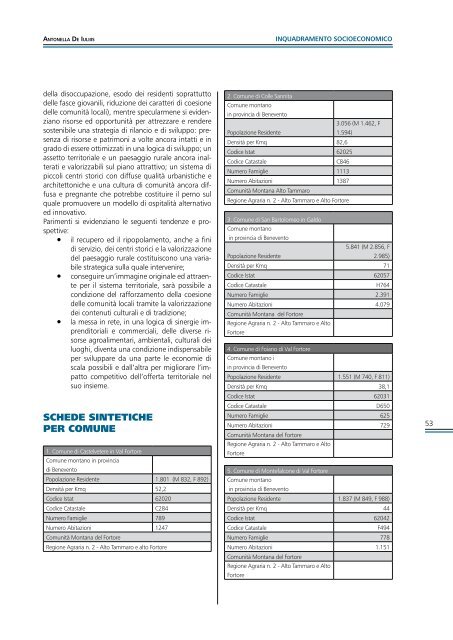
SCHEDE SINTETICHE<br />
PER COMUNE<br />
1. Comune <strong>di</strong> Castelvetere in V<strong>al</strong> <strong>Fortore</strong><br />
Comune montano in provincia<br />
<strong>di</strong> Benevento<br />
Popolazione Residente 1.801 (M 832, F 892)<br />
Densità per Kmq 52,2<br />
Co<strong>di</strong>ce Istat 62020<br />
Co<strong>di</strong>ce Catast<strong>al</strong>e<br />
C284<br />
Numero Famiglie 789<br />
Numero Abitazioni 1247<br />
Comunità Montana del <strong>Fortore</strong><br />
Regione Agraria n. 2 - Alto Tammaro e <strong>al</strong>to <strong>Fortore</strong><br />
2. Comune <strong>di</strong> Colle Sannita<br />
Comune montano<br />
in provincia <strong>di</strong> Benevento<br />
3.056 (M 1.462, F<br />
Popolazione Residente<br />
1.594)<br />
Densità per Kmq 82,6<br />
Co<strong>di</strong>ce Istat 62025<br />
Co<strong>di</strong>ce Catast<strong>al</strong>e<br />
C846<br />
Numero Famiglie 1113<br />
Numero Abitazioni 1387<br />
Comunità Montana Alto Tammaro<br />
Regione Agraria n. 2 - Alto Tammaro e Alto <strong>Fortore</strong><br />
3. Comune <strong>di</strong> San Bartolomeo in G<strong>al</strong>do<br />
Comune montano<br />
in provincia <strong>di</strong> Benevento<br />
5.841 (M 2.856, F<br />
Popolazione Residente<br />
2.985)<br />
Densità per Kmq 71<br />
Co<strong>di</strong>ce Istat 62057<br />
Co<strong>di</strong>ce Catast<strong>al</strong>e<br />
H764<br />
Numero Famiglie 2.391<br />
Numero Abitazioni 4.079<br />
Comunità Montana del <strong>Fortore</strong><br />
Regione Agraria n. 2 - Alto Tammaro e Alto<br />
<strong>Fortore</strong><br />
4. Comune <strong>di</strong> Foiano <strong>di</strong> V<strong>al</strong> <strong>Fortore</strong><br />
Comune montano i<br />
in provincia <strong>di</strong> Benevento<br />
Popolazione Residente 1.551 (M 740, F 811)<br />
Densità per Kmq 38,1<br />
Co<strong>di</strong>ce Istat 62031<br />
Co<strong>di</strong>ce Catast<strong>al</strong>e<br />
D650<br />
Numero Famiglie 625<br />
Numero Abitazioni 729<br />
Comunità Montana del <strong>Fortore</strong><br />
Regione Agraria n. 2 - Alto Tammaro e Alto<br />
<strong>Fortore</strong><br />
5. Comune <strong>di</strong> Montef<strong>al</strong>cone <strong>di</strong> V<strong>al</strong> <strong>Fortore</strong><br />
Comune montano<br />
in provincia <strong>di</strong> Benevento<br />
Popolazione Residente 1.837 (M 849, F 988)<br />
Densità per Kmq 44<br />
Co<strong>di</strong>ce Istat 62042<br />
Co<strong>di</strong>ce Catast<strong>al</strong>e<br />
F494<br />
Numero Famiglie 778<br />
Numero Abitazioni 1.151<br />
Comunità Montana del <strong>Fortore</strong><br />
Regione Agraria n. 2 - Alto Tammaro e Alto<br />
<strong>Fortore</strong><br />
53