Untitled - University of New Orleans
Untitled - University of New Orleans
Untitled - University of New Orleans
You also want an ePaper? Increase the reach of your titles
YUMPU automatically turns print PDFs into web optimized ePapers that Google loves.
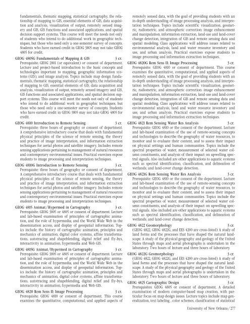
fundamentals, thematic mapping, statistical cartography, the relationship<br />
<strong>of</strong> mapping to GIS, essential elements <strong>of</strong> GIS, data acquisition<br />
and analysis, visualization <strong>of</strong> output, remotely sensed imagery<br />
and GIS, GIS functions and associated applications, and spatial<br />
decision support systems. This course will meet the needs not only<br />
<strong>of</strong> students who intend to do additional work in geographic techniques,<br />
but those who need only a one-semester survey <strong>of</strong> concepts.<br />
Students who have earned credit in GEOG 3805 may not take GEOG<br />
4805 for credit.<br />
GEOG 4805G Fundamentals <strong>of</strong> Mapping & GIS<br />
3 cr.<br />
Prerequisite: GEOG 2801 (or equivalent) or consent <strong>of</strong> department.<br />
Lecture and project-based introduction to the basic concepts and<br />
technologies important to mapping, geographic information systems<br />
(GIS), and image analysis. Topics include map design fundamentals,<br />
thematic mapping, statistical cartography, the relationship<br />
<strong>of</strong> mapping to GIS, essential elements <strong>of</strong> GIS, data acquisition and<br />
analysis, visualization <strong>of</strong> output, remotely sensed imagery and GIS,<br />
GIS functions and associated applications, and spatial decision support<br />
systems. This course will meet the needs not only <strong>of</strong> students<br />
who intend to do additional work in geographic techniques, but<br />
those who need only a one-semester survey <strong>of</strong> concepts. Students<br />
who have earned credit in GEOG 3805 may not take GEOG 4805 for<br />
credit.<br />
GEOG 4810 Introduction to Remote Sensing<br />
3 cr.<br />
Prerequisite: three hours <strong>of</strong> geography or consent <strong>of</strong> department.<br />
A comprehensive introductory course that deals with fundamental<br />
physical principles <strong>of</strong> the science <strong>of</strong> remote sensing, the theory<br />
and practice <strong>of</strong> image interpretation, and information extraction<br />
techniques for aerial photos and satellite imagery. Includes remote<br />
sensing applications pertaining to management <strong>of</strong> natural resources<br />
and contemporary environmental issues. Practical exercises expose<br />
students to image processing and interpretation techniques.<br />
GEOG 4810G Introduction to Remote Sensing<br />
3 cr.<br />
Prerequisite: three hours <strong>of</strong> geography or consent <strong>of</strong> department.<br />
A comprehensive introductory course that deals with fundamental<br />
physical principles <strong>of</strong> the science <strong>of</strong> remote sensing, the theory<br />
and practice <strong>of</strong> image interpretation, and information extraction<br />
techniques for aerial photos and satellite imagery. Includes remote<br />
sensing applications pertaining to management <strong>of</strong> natural resources<br />
and contemporary environmental issues. Practical exercises expose<br />
students to image processing and interpretation techniques.<br />
GEOG 4815 Animat/Hypermed in Cartography<br />
3 cr.<br />
Prerequisite: GEOG 3805 or 4805 or consent <strong>of</strong> department. Lecture<br />
and lab-based examination <strong>of</strong> principles <strong>of</strong> cartographic animation,<br />
and the role <strong>of</strong> hypermedia; and the World Wide Web in the<br />
dissemination access, and display <strong>of</strong> geospatial information. Topics<br />
include: the history <strong>of</strong> cartographic animation, principles and<br />
mechanics <strong>of</strong> animation, digital color systems, affine transformations,<br />
autotracing and shapeblending, digital relief and fly-bys,<br />
interactivity in animation, hypermedia and Web GIS.<br />
GEOG 4815G Animat/Hypermed in Cartography<br />
3 cr.<br />
Prerequisite: GEOG 3805 or 4805 or consent <strong>of</strong> department. Lecture<br />
and lab-based examination <strong>of</strong> principles <strong>of</strong> cartographic animation,<br />
and the role <strong>of</strong> hypermedia; and the World Wide Web in the<br />
dissemination access, and display <strong>of</strong> geospatial information. Topics<br />
include: the history <strong>of</strong> cartographic animation, principles and<br />
mechanics <strong>of</strong> animation, digital color systems, affine transformations,<br />
autotracing and shapeblending, digital relief and fly-bys,<br />
interactivity in animation, hypermedia and Web GIS.<br />
GEOG 4820 Rem Sens II: Image Processing<br />
3 cr.<br />
Prerequisite: GEOG 4810 or consent <strong>of</strong> department. This course<br />
examines the quantitative, computational, and applied aspects <strong>of</strong><br />
remotely sensed data, with the goal <strong>of</strong> providing students with an<br />
in-depth understanding <strong>of</strong> image processing analysis, and interpretation<br />
techniques. Topics include scientific visualization, geometric,<br />
radiometric, and atmospheric correction: image enhancement<br />
and manipulation, information extraction, land-use and land-cover<br />
change detection, integration <strong>of</strong> GIS and remote sensing data and<br />
spatial modeling. Class applications will address issues related to<br />
environmental analysis, land and water resource inventory and<br />
use, and urban analysis. Practical exercises expose students to<br />
image processing and information extraction techniques.<br />
GEOG 4820G Rem Sens II: Image Processing<br />
3 cr.<br />
Prerequisite: GEOG 4810 or consent <strong>of</strong> department. This course<br />
examines the quantitative, computational, and applied aspects <strong>of</strong><br />
remotely sensed data, with the goal <strong>of</strong> providing students with an<br />
in-depth understanding <strong>of</strong> image processing analysis, and interpretation<br />
techniques. Topics include scientific visualization, geometric,<br />
radiometric, and atmospheric correction: image enhancement<br />
and manipulation, information extraction, land-use and land-cover<br />
change detection, integration <strong>of</strong> GIS and remote sensing data and<br />
spatial modeling. Class applications will address issues related to<br />
environmental analysis, land and water resource inventory and<br />
use, and urban analysis. Practical exercises expose students to<br />
image processing and information extraction techniques.<br />
GEOG 4821 Rem Sensing Water Res Analysis<br />
3 cr.<br />
Prerequisite: GEOG 4810 or the consent <strong>of</strong> the department. Lecture<br />
and lab-based examination <strong>of</strong> the use <strong>of</strong> remote-sensing concepts<br />
and technologies to describe the geography <strong>of</strong> water resources, to<br />
monitor and to evaluate their content, and to assess their impact<br />
on physical settings and human communities. Topics include the<br />
spectral properties <strong>of</strong> water, measurement <strong>of</strong> selected water column<br />
constituents, and analysis <strong>of</strong> their impact on upwelling spectral<br />
signals. Also included are other applications to aquatic systems<br />
such as spectral identification, classification, and delineation <strong>of</strong><br />
wetlands; and land-cover change detection.<br />
GEOG 4821G Rem Sensing Water Res Analysis<br />
3 cr.<br />
Prerequisite: GEOG 4810 or the consent <strong>of</strong> the department. Lecture<br />
and lab-based examination <strong>of</strong> the use <strong>of</strong> remote-sensing concepts<br />
and technologies to describe the geography <strong>of</strong> water resources, to<br />
monitor and to evaluate their content, and to assess their impact<br />
on physical settings and human communities. Topics include the<br />
spectral properties <strong>of</strong> water, measurement <strong>of</strong> selected water column<br />
constituents, and analysis <strong>of</strong> their impact on upwelling spectral<br />
signals. Also included are other applications to aquatic systems<br />
such as spectral identification, classification, and delineation <strong>of</strong><br />
wetlands; and land-cover change detection.<br />
GEOG 4822 Geomorphology<br />
3 cr.<br />
(GEOG 4822, GEOG 4822G, and EES 4200 are cross-listed) A study <strong>of</strong><br />
land forms and the processes that have shaped the natural landscape.<br />
A study <strong>of</strong> the physical geography and geology <strong>of</strong> the United<br />
States through maps and aerial photographs is undertaken in the<br />
laboratory. Two hours <strong>of</strong> lecture and three hours <strong>of</strong> laboratory.<br />
GEOG 4822G Geomorphology<br />
3 cr.<br />
(GEOG 4822, GEOG 4822G, and EES 4200 are cross-listed) A study <strong>of</strong><br />
land forms and the processes that have shaped the natural landscape.<br />
A study <strong>of</strong> the physical geography and geology <strong>of</strong> the United<br />
States through maps and aerial photographs is undertaken in the<br />
laboratory. Two hours <strong>of</strong> lecture and three hours <strong>of</strong> laboratory.<br />
GEOG 4825 Cartographic Design<br />
3 cr.<br />
Prerequisites: GEOG 4805 or consent <strong>of</strong> department. A detailed<br />
examination <strong>of</strong> modern computer-based map creation, with particular<br />
focus on map design issues. Lecture topics include map generalization,<br />
text labeling , color schemes, classification <strong>of</strong> statistical<br />
<strong>University</strong> <strong>of</strong> <strong>New</strong> <strong>Orleans</strong>/277


