

NORTH AND SOUTH AMERICA - CNATRA - The US Navy
NORTH AND SOUTH AMERICA - CNATRA - The US Navy
NORTH AND SOUTH AMERICA - CNATRA - The US Navy

Create successful ePaper yourself
Turn your PDF publications into a flip-book with our unique Google optimized e-Paper software.
EASTBOUND<br />
TRANSITION TO NEW YORK OCEANIC CTA/FIR<br />
VIA: ORF AR9 ZIBUT<br />
All airspace operators transitioning the New York Center West<br />
Atlantic Route System (WATRS) via ZIBUT intersection, en route<br />
to the New York Center North Atlantic RNP/MNPS/RVSM<br />
airspace, are encouraged to flight plan via:<br />
ZIBUT [DCT] LARGE [DCT]: SLATN [or] JOBOC [or] DOVEY<br />
Operators opting to flight plan via any other fix or<br />
Latitude/Longitude coordinates east of ZIBUT intersection shall<br />
expect no higher than FL290 and may be rerouted to<br />
accommodate WATRS nonradar traffic.<br />
NOTE: This route may be filed bidirectionally<br />
SIGNIFICANT POINT COORDINATES<br />
ZIBUT N36°56.30’ / W072°40.00’<br />
LARGE N39°17.12’ / W069°18.07’<br />
SLATN N39°07.00’ / W067°00.00’<br />
JOBOC N40°07.00’ / W067°00.00’<br />
DOVEY N41°07.00’ / W067°00.00’<br />
VIA: KAYYT [DCT] 06000W Longitude<br />
Operators departing the metropolitan New York Area destined to<br />
the African Continent may file via: LINND-KAYYT-[TO<br />
3800N/06000W or South, e.g. 3800N/06000W or 3700N/06000W<br />
or 3600N/06000W] – flight planned route.<br />
NOTE: This route may be filed bidirectionally<br />
SIGNIFICANT POINT COORDINATES<br />
LINND N39°24’35.130” / W071°42’37.750”<br />
KAYYT N38°52’37.839” / W067°34’22.287”<br />
<strong>NORTH</strong>BOUND<br />
TRANSITION TO NEW YORK OCEANIC CTA/FIR<br />
<strong>NORTH</strong>BOUND WATRS PL<strong>US</strong> ROUTE STRUCTURE ACCESS TO<br />
NEW YORK METRO AREA<br />
Northbound airspace users exiting New York Center’s West<br />
Atlantic Route System (WATRS) destined to New York Area<br />
airports on ATS routes: L453, L454, L455, L456, L457, L459, L461<br />
<strong>AND</strong> L462 shall flight plan and file the following transition routes<br />
to join standard airport arrival routing:<br />
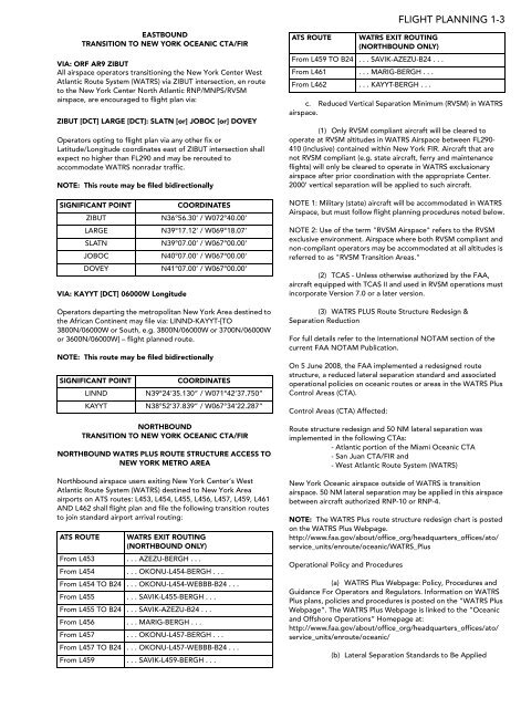
ATS ROUTE WATRS EXIT ROUTING<br />
(<strong>NORTH</strong>BOUND ONLY)<br />
From L453 . . . AZEZU-BERGH . . .<br />
From L454 . . . OKONU-L454-BERGH . . .<br />
From L454 TO B24 . . . OKONU-L454-WEBBB-B24 . . .<br />
From L455 . . . SAVIK-L455-BERGH . . .<br />
From L455 TO B24 . . . SAVIK-AZEZU-B24 . . .<br />
From L456 . . . MARIG-BERGH . . .<br />
From L457 . . . OKONU-L457-BERGH . . .<br />
From L457 TO B24 . . . OKONU-L457-WEBBB-B24 . . .<br />
From L459 . . . SAVIK-L459-BERGH . . .<br />
ATS ROUTE WATRS EXIT ROUTING<br />
(<strong>NORTH</strong>BOUND ONLY)<br />
From L459 TO B24 . . . SAVIK-AZEZU-B24 . . .<br />
From L461 . . . MARIG-BERGH . . .<br />
From L462 . . . KAYYT-BERGH . . .<br />
FLIGHT PLANNING 1-3<br />
c. Reduced Vertical Separation Minimum (RVSM) in WATRS<br />
airspace.<br />
(1) Only RVSM compliant aircraft will be cleared to<br />
operate at RVSM altitudes in WATRS Airspace between FL290-<br />
410 (inclusive) contained within New York FIR. Aircraft that are<br />
not RVSM compliant (e.g. state aircraft, ferry and maintenance<br />
flights) will only be cleared to operate in WATRS exclusionary<br />
airspace after prior coordination with the appropriate Center.<br />
2000’ vertical separation will be applied to such aircraft.<br />
NOTE 1: Military (state) aircraft will be accommodated in WATRS<br />
Airspace, but must follow flight planning procedures noted below.<br />
NOTE 2: Use of the term "RVSM Airspace" refers to the RVSM<br />
exclusive environment. Airspace where both RVSM compliant and<br />
non-compliant operators may be accommodated at all altitudes is<br />
referred to as "RVSM Transition Areas."<br />
(2) TCAS - Unless otherwise authorized by the FAA,<br />
aircraft equipped with TCAS II and used in RVSM operations must<br />
incorporate Version 7.0 or a later version.<br />
(3) WATRS PL<strong>US</strong> Route Structure Redesign &<br />
Separation Reduction<br />
For full details refer to the International NOTAM section of the<br />
current FAA NOTAM Publication.<br />
On 5 June 2008, the FAA implemented a redesigned route<br />
structure, a reduced lateral separation standard and associated<br />
operational policies on oceanic routes or areas in the WATRS Plus<br />
Control Areas (CTA).<br />
Control Areas (CTA) Affected:<br />
Route structure redesign and 50 NM lateral separation was<br />
implemented in the following CTAs:<br />
- Atlantic portion of the Miami Oceanic CTA<br />
- San Juan CTA/FIR and<br />
- West Atlantic Route System (WATRS)<br />
New York Oceanic airspace outside of WATRS is transition<br />
airspace. 50 NM lateral separation may be applied in this airspace<br />
between aircraft authorized RNP-10 or RNP-4.<br />
NOTE: <strong>The</strong> WATRS Plus route structure redesign chart is posted<br />
on the WATRS Plus Webpage.<br />
http://www.faa.gov/about/office_org/headquarters_offices/ato/<br />
service_units/enroute/oceanic/WATRS_Plus<br />
Operational Policy and Procedures<br />
(a) WATRS Plus Webpage: Policy, Procedures and<br />
Guidance For Operators and Regulators. Information on WATRS<br />
Plus plans, policies and procedures is posted on the “WATRS Plus<br />
Webpage”. <strong>The</strong> WATRS Plus Webpage is linked to the “Oceanic<br />
and Offshore Operations” Homepage at:<br />
http://www.faa.gov/about/office_org/headquarters_offices/ato/<br />
service_units/enroute/oceanic/<br />
(b) Lateral Separation Standards to Be Applied


