NORTH AND SOUTH AMERICA - CNATRA - The US Navy
NORTH AND SOUTH AMERICA - CNATRA - The US Navy
NORTH AND SOUTH AMERICA - CNATRA - The US Navy
You also want an ePaper? Increase the reach of your titles
YUMPU automatically turns print PDFs into web optimized ePapers that Google loves.
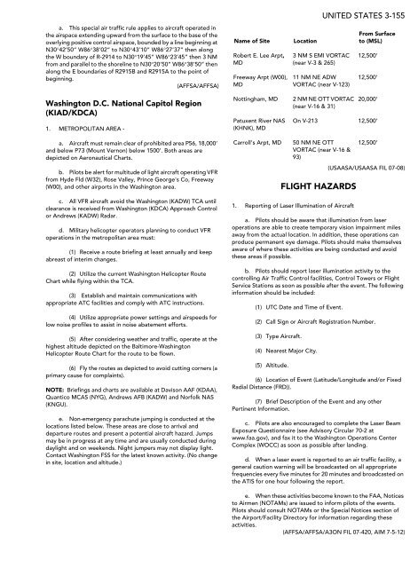
a. This special air traffic rule applies to aircraft operated in<br />
the airspace extending upward from the surface to the base of the<br />
overlying positive control airspace, bounded by a line beginning at<br />
N30°42’50” W86°38’02” to N30°43’10” W86°27’37” then along<br />
the W boundary of R-2914 to N30°19’45” W86°23’45” then 3 NM<br />
from and parallel to the shoreline to N30°20’50” W86°38’50” then<br />
along the E boundaries of R2915B and R2915A to the point of<br />
beginning.<br />
(AFFSA/AFFSA)<br />
Washington D.C. National Capitol Region<br />
(KIAD/KDCA)<br />
1. METROPOLITAN AREA -<br />
a. Aircraft must remain clear of prohibited area P56, 18,000’<br />
and below P73 (Mount Vernon) below 1500’. Both areas are<br />
depicted on Aeronautical Charts.<br />
b. Pilots be alert for multitude of light aircraft operating VFR<br />
from Hyde Fld (W32), Rose Valley, Prince George's Co, Freeway<br />
(W00), and other airports in the Washington area.<br />
c. All VFR aircraft avoid the Washington (KADW) TCA until<br />
clearance is received from Washington (KDCA) Approach Control<br />
or Andrews (KADW) Radar.<br />
d. Military helicopter operators planning to conduct VFR<br />
operations in the metropolitan area must:<br />
(1) Receive a route briefing at least annually and keep<br />
abreast of interim changes.<br />
(2) Utilize the current Washington Helicopter Route<br />
Chart while flying within the TCA.<br />
(3) Establish and maintain communications with<br />
appropriate ATC facilities and comply with ATC instructions.<br />
(4) Utilize appropriate power settings and airspeeds for<br />
low noise profiles to assist in noise abatement efforts.<br />
(5) After considering weather and traffic, operate at the<br />
highest altitude depicted on the Baltimore-Washington<br />
Helicopter Route Chart for the route to be flown.<br />
(6) Fly the routes as depicted to avoid cutting corners (a<br />
primary cause for complaints).<br />
NOTE: Briefings and charts are available at Davison AAF (KDAA),<br />
Quantico MCAS (NYG), Andrews AFB (KADW) and Norfolk NAS<br />
(KNGU).<br />
e. Non-emergency parachute jumping is conducted at the<br />
locations listed below. <strong>The</strong>se areas are close to arrival and<br />
departure routes and present a potential aircraft hazard. Jumps<br />
may be in progress at any time and are usually conducted during<br />
daylight and on weekends. Night jumpers may not display light.<br />
Contact Washington FSS for the latest known activity. (No change<br />
in site, location and altitude.)<br />
Name of Site Location<br />
Robert E. Lee Arpt,<br />
MD<br />
Freeway Arpt (W00),<br />
MD<br />
FLIGHT HAZARDS<br />
1. Reporting of Laser Illumination of Aircraft<br />
UNITED STATES 3-155<br />
(<strong>US</strong>AASA/<strong>US</strong>AASA FIL 07-08)<br />
a. Pilots should be aware that illumination from laser<br />
operations are able to create temporary vision impairment miles<br />
away from the actual location. In addition, these operations can<br />
produce permanent eye damage. Pilots should make themselves<br />
aware of where these activities are being conducted and avoid<br />
these areas if possible.<br />
b. Pilots should report laser illumination activity to the<br />
controlling Air Traffic Control facilities, Control Towers or Flight<br />
Service Stations as soon as possible after the event. <strong>The</strong> following<br />
information should be included:<br />
(1) UTC Date and Time of Event.<br />
(2) Call Sign or Aircraft Registration Number.<br />
(3) Type Aircraft.<br />
(4) Nearest Major City.<br />
(5) Altitude.<br />
3 NM S EMI VORTAC<br />
(near V-3 & 265)<br />
11 NM NE ADW<br />
VORTAC (near V-123)<br />
Nottingham, MD 2 NM NE OTT VORTAC<br />
(near V-16 & 31)<br />
Patuxent River NAS<br />
(KHNK), MD<br />
From Surface<br />
to (MSL)<br />
12,500’<br />
12,500’<br />
20,000’<br />
On V-213 12,500’<br />
Carroll's Arpt, MD 50 NM NE OTT<br />
VORTAC (near V-16 &<br />
93)<br />
12,500’<br />
(6) Location of Event (Latitude/Longitude and/or Fixed<br />
Radial Distance (FRD)).<br />
(7) Brief Description of the Event and any other<br />
Pertinent Information.<br />
c. Pilots are also encouraged to complete the Laser Beam<br />
Exposure Questionnaire (see Advisory Circular 70-2 at<br />
www.faa.gov), and fax it to the Washington Operations Center<br />
Complex (WOCC) as soon as possible after landing.<br />
d. When a laser event is reported to an air traffic facility, a<br />
general caution warning will be broadcasted on all appropriate<br />
frequencies every five minutes for 20 minutes and broadcasted on<br />
the ATIS for one hour following the report.<br />
e. When these activities become known to the FAA, Notices<br />
to Airmen (NOTAMs) are issued to inform pilots of the events.<br />
Pilots should consult NOTAMs or the Special Notices section of<br />
the Airport/Facility Directory for information regarding these<br />
activities.<br />
(AFFSA/AFFSA/A3ON FIL 07-420, AIM 7-5-12)


