

NORTH AND SOUTH AMERICA - CNATRA - The US Navy
NORTH AND SOUTH AMERICA - CNATRA - The US Navy
NORTH AND SOUTH AMERICA - CNATRA - The US Navy

Create successful ePaper yourself
Turn your PDF publications into a flip-book with our unique Google optimized e-Paper software.
3-156 UNITED STATES<br />
FOREST FIRE SEASON - Many Military Training Routes (MTRs)<br />
traverse areas of mountainous forest and range lands. Flight crews<br />
must be alert for fire suppression activities using aircraft during the<br />
fire season. In many cases a NOTAM designating a temporary<br />
flight restriction area will be in effect for such areas when a fire<br />
exists. All aircrews should be extremely alert for such areas<br />
whether designated or not and avoid such areas by at least 5 NM.<br />
Typical fire seasons for various regions are as follows:<br />
NE <strong>US</strong> - March, April, May<br />
SE <strong>US</strong> - March, April, May, September, October, November<br />
ARIZONA/NEW MEXICO - April, May, June, July, September,<br />
October, November<br />
CALIFORNIA - May, June, July, August, September, October,<br />
November, December<br />
COLORADO/WYOMING - May, June, July, August<br />
N. DAKOTA - May, June, July, August<br />
UTAH/NEVADA/IDAHO - June, July, August, September<br />
MONTANA - June, July, August, September<br />
OREGON/WASHINGTON - June, July, August, September,<br />
October<br />
(AFFSA/AFFSA)<br />
Alabama<br />
1. FORT RUCKER (KOZR) - Extreme caution is recommended<br />
when flying below 5000’ within and around A211, Fort Rucker<br />
(KOZR), due to intensive IFR and VFR student training in fixed<br />
and rotary wing aircraft. Transient pilots are advised that there is<br />
restricted visibility from the right side of instrument training<br />
aircraft in which student pilots are performing hooded flight.<br />
2. FORT RUCKER (KOZR) - CAUTION - Due to high density<br />
helicopter Night Vision Device (NVD) reduced lighting flight<br />
training, an acute collision potential exists to unannounced<br />
transient air operations in the following training airspace:<br />
a. APPROPRIATE TRAINING BOUNDARIES: 60 NM radius<br />
around Cairns AAF (KOZR) (N31°16.6’ W85°42.6’). Floor: Surface.<br />
Ceiling: 500’ AGL.<br />
b. TIME HAZARDO<strong>US</strong> ACTIVITY: Sunset to sunrise in VFR<br />
conditions, seven (7) days a week. In view of the above, it is<br />
strongly advised that transiting pilots operating in VFR conditions<br />
contact Cairns (KOZR) Approach Control, prior to entering above<br />
area, in order to obtain reduced lighting helicopter traffic<br />
information and suggested best routing through the area. Pilots<br />
unable to make such contact or not desirous of this service are<br />
strongly advised to cross above 500’ AGL.<br />
(<strong>US</strong>AASAIFC/FIL 95-27)<br />
3. Weather observation. Visibility limitations at airfield in NM<br />
are: 2.5 NE, 1.5 S, .5 SW, .5 W, 2 NW and 2 N.<br />
(AFFSA/AFFSA)<br />
Alaska<br />
1. EARECKSON AS (PASY/SYA) - CAUTION - Radiation hazard<br />
area from surface to 16,000’ MSL for aircraft out to 3 NM with<br />
externally mounted electro explosives devices (EED). Possible<br />
interference with electronic equipment for aircraft out to 3 NM<br />
(military) or 62 NM (civilian) from a phase array radar antenna on<br />
the NW corner of Eareckson (PASY/SYA) (N52°44’ E174°05’) on a<br />
bearing of 250 through 028T. <strong>The</strong>se are parameters for<br />
information only. EED equipped aircraft must advise Base<br />
Operations prior to departure. Possible 30 minute arrival delay<br />
for EED aircraft.<br />
(AFFSA/AFFSA)<br />
2. Unmanned Aerial Vehicle (UAV)/Remotely Operated Aircraft<br />
(ROA) - Expect UAV/ROA operations in and around R2202,<br />
R2203, R2205, R2211, Firebird Flight Landing Strip (vicinity<br />
N64º37.43’ W146º38.83’), Donnelly Flight Landing Strip (vicinity<br />
N63°50.00’ W145°43.91’), Husky Drop Zone (vicinity N64º45.97’<br />
W147º04.89’), Allen AAF and Bryant AHP. For specific<br />
information regarding UAV/ROA operating times and locations,<br />
contact Eielson Range Control (1-800-758-8723, C907-377-3125,<br />
125.3/229.4), FSS, ATC or current NOTAM.<br />
(<strong>US</strong>AASA/<strong>US</strong>AASA FIL 04-6)<br />
Arkansas<br />
1. LITTLE ROCK AFB (KLRF) - CAUTION - High density C130<br />
student flying training in the vicinity of Little Rock AFB (KLRF) and<br />
on low level Slow Routes (SR) within Arkansas; 0000-2000Z++<br />
Monday-Friday, occasionally weekends. Extensive use of All<br />
American Drop Zone, Little Rock VORTAC R-332/15 DME and<br />
Blackjack Drop Zone, Little Rock VORTAC R-009/33 DME; 0000-<br />
2000Z++ Monday-Friday, occasionally weekends. Drop zones are<br />
used for personnel and cargo, including IMC (AWADS) drops.<br />
(AFFSA/AFFSA)<br />
California<br />
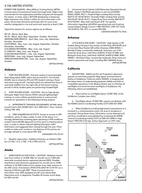
1. GOLDSTONE - NASA and the Jet Propulsion Laboratory<br />
operate an extremely powerful deep space communications<br />
facility at Goldstone, California within R2502N. In keeping with<br />
the latest memo of understanding between NASA and DoD on<br />
compatible operations in the Mojave Desert area to minimize all<br />
overflights and avoid low level overflights of Goldstone, the<br />
following criteria are established:<br />
a. <strong>The</strong>re will be no overflights below 15,000’ MSL of the<br />
Goldstone Complex (see chart).<br />
b. Overflights above 15,000’ MSL require coordination with<br />
the R2508 Central Coordinating Facility (CCF) DSN 527-2508.<br />
c. When Goldstone is making high power transmissions or is<br />
involved in a critical/sensitive event, the area of avoidance is<br />
increased. During these times, information can be obtained and<br />
real-time coordination accomplished by contacting the R2508<br />
Central Coordinating Facility (CCF) at DSN 527-2508 or High<br />
Desert TRACON (Call sign Joshua Approach) on UHF radio.


