- Page 4 and 5:
“To be the leading, people center
- Page 9 and 10:
“To be the leading, people center
- Page 11 and 12:
“To be the leading, people center
- Page 13 and 14:
“To be the leading, people center
- Page 15 and 16:
“To be the leading, people center
- Page 17 and 18:
“To be the leading, people center
- Page 19 and 20:
“To be the leading, people center
- Page 21 and 22:
“To be the leading, people center
- Page 23 and 24:
“To be the leading, people center
- Page 25 and 26:
“To be the leading, people center
- Page 27 and 28:
“To be the leading, people center
- Page 29 and 30:
“To be the leading, people center
- Page 31 and 32:
“To be the leading, people center
- Page 33 and 34:
“To be the leading, people center
- Page 35 and 36:
“To be the leading, people center
- Page 37 and 38:
“To be the leading, people center
- Page 39 and 40:
“To be the leading, people center
- Page 41 and 42:
“To be the leading, people center
- Page 43 and 44:
“To be the leading, people center
- Page 45 and 46:
“To be the leading, people center
- Page 47 and 48:
“To be the leading, people center
- Page 49 and 50:
“To be the leading, people center
- Page 51 and 52:
“To be the leading, people center
- Page 53 and 54:
“To be the leading, people center
- Page 55 and 56:
“To be the leading, people center
- Page 57 and 58:
“To be the leading, people center
- Page 59 and 60:
“To be the leading, people center
- Page 61 and 62:
“To be the leading, people center
- Page 63 and 64:
“To be the leading, people center
- Page 65 and 66:
“To be the leading, people center
- Page 67 and 68: “To be the leading, people center
- Page 69 and 70: “To be the leading, people center
- Page 71 and 72: “To be the leading, people center
- Page 73 and 74: “To be the leading, people center
- Page 75 and 76: “To be the leading, people center
- Page 77 and 78: “To be the leading, people center
- Page 79 and 80: “To be the leading, people center
- Page 81 and 82: “To be the leading, people center
- Page 83 and 84: “To be the leading, people center
- Page 85 and 86: “To be the leading, people center
- Page 87 and 88: “To be the leading, people center
- Page 89 and 90: “To be the leading, people center
- Page 91 and 92: 3.10.3 Existing Pump Stations Infra
- Page 93 and 94: 3.10.4 Existing Pump Stations Infra
- Page 95 and 96: General information Zone 1 Zone 2 Z
- Page 97 and 98: 3.10.7 Existing Reticulation Infras
- Page 99 and 100: 3.10.13 Future Bulk Sanitation Infr
- Page 101 and 102: Opportunities High influx of potent
- Page 103 and 104: • Mandla Mthethwa - complained ab
- Page 105 and 106: • Clinic and RDP houses: the comm
- Page 107 and 108: Available land for agricultural and
- Page 109 and 110: CHAPTER: FOUR4 VISION AND MISSION O
- Page 111 and 112: 4.2 NINE (9) STRATEGIC FOCUS AREAS
- Page 113 and 114: Promote and support sustainability
- Page 115 and 116: • The fact that the largest numbe
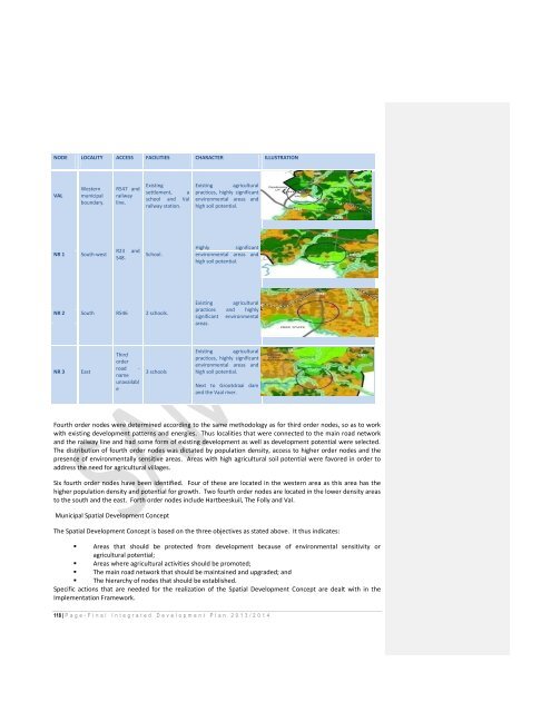
- Page 117: The myriad of third order routes pr
- Page 121 and 122: Figure 26/7: OPEN SPACE (left)PROPO
- Page 123 and 124: Third order nodes will serve only a
- Page 125 and 126: Development Principle 6: Prioritize
- Page 127 and 128: Industrial 1 Industry (excludingnox
- Page 129 and 130: • The ability of the municipality
- Page 131 and 132: 4.4 IMPLEMENTATION FRAMEWORK OF SDF
- Page 133 and 134: ACTION LOCATION ESTIMATED COST REAS
- Page 135 and 136: CHAPTER FIVE5 STRATEGIC OBJECTIVES,
- Page 137 and 138: ISSUE DESIRED OUTCOME KEY PERFORMAN
- Page 139 and 140: ISSUE DESIRED OUTCOME KEY PERFORMAN
- Page 141 and 142: ISSUE DESIRED OUTCOME KEY PERFORMAN
- Page 143 and 144: Staff TurnoverLabour Relations andC
- Page 145 and 146: KEY PERFORMANCEAREA(linkage to IDP)
- Page 147 and 148: 8. ContractsManage and safekeeping
- Page 149 and 150: KEY PERFORMANCEAREA(linkage to IDP)
- Page 151 and 152: 2. Submitting the Annual FinancialS
- Page 153 and 154: 2. Fraud ReportingHot LineManage th
- Page 155 and 156: KEY PERFORMANCE AREA(linkage to IDP
- Page 157 and 158: monthly basis4.Prepaid Electricity
- Page 159 and 160: Responsible for the procurementof S
- Page 161 and 162: Informal DebtorsManagement of infor
- Page 163 and 164: management of the EEP(Employment Eq
- Page 165 and 166: OccupationalHealth & Safety Act at
- Page 167 and 168: External Service ProviderManage the
- Page 169 and 170:
KEY PERFORMANCEAREA(linkage to IDP)
- Page 171 and 172:
Water ConnectionsResponsible and ma
- Page 173 and 174:
KEY PERFORMANCE AREA(linkage to IDP
- Page 175 and 176:
KEY PERFORMANCE AREA(linkage to IDP
- Page 177 and 178:
Sport FieldsManage themaintenance o
- Page 179 and 180:
performance of theappointed externa
- Page 181 and 182:
KEY PERFORMANCEAREA(linkage to IDP)
- Page 183 and 184:
5.1 PROGRAMMES AND PROJECTS FOR THE
- Page 185 and 186:
PRIORITY OUTPUTS AND BUDGET FOR 201
- Page 187 and 188:
PROGRAMME 3: CRIME PREVENTION AND C
- Page 189 and 190:
schoolsPROGRAMME 4: TRANSPORT REGUL
- Page 191 and 192:
SOPA PRIORITIES KEY ACTIVITIES 2013
- Page 193 and 194:
DistrictNUNBER OF ECDCENTES FUNDEDB
- Page 195 and 196:
SOPA ISSIUE KEY ACTIVITIES TIMEFRAM
- Page 197 and 198:
SOPAISSIUEKEY ACTIVITIES TIMEFRAME
- Page 199 and 200:
Municipal Infrastructure Grant for
- Page 201 and 202:
Phase no:GSDM No. LOCALITY Project
- Page 203 and 204:
2013/2014ENVIRONMENTAL PROTECTION A
- Page 205 and 206:
funderSPECIAL PROGRAMMES AND PROJEC
- Page 207 and 208:
funderSPECIAL PROGRAMMES AND PROJEC
- Page 209 and 210:
6.3 BENEFITS OF PERFORMANCE MANAGEM
- Page 211 and 212:
(c) Models help align strategic pla
- Page 213 and 214:
The objectives and benefits of havi
- Page 215 and 216:
Be responsive to the needs of the l
- Page 217 and 218:
CHAPTER SEVEN7. GOOD GOVERNANCE AND
- Page 219 and 220:
the gas chambers, conducted experim
- Page 221 and 222:
The Audit Committee is an independe
- Page 223 and 224:
The democratically elected stakehol
- Page 225 and 226:
Developing and subsequently reviewi
- Page 227 and 228:
LEKWA LOCAL MUNICIPALITY FUNCTIONAL
- Page 229 and 230:
The municipality prepared and submi
- Page 231 and 232:
Incapacity Due to Ill-Health/Injury
- Page 233 and 234:
easonably expects to derive economi
- Page 235 and 236:
Except in so far as capital project
- Page 237 and 238:
7.24 ANNUAL BUDGET FOR THE FINANCIA
- Page 239 and 240:
Table 1.Consolidated Overview of th
- Page 241 and 242:
The table indicate that the municip
- Page 243 and 244:
ultimately all connections will be
- Page 245 and 246:
MP305 Lekwa - Table A5 Budgeted Cap
- Page 247 and 248:
MP305 Lekwa - Supporting Table SA30
- Page 249 and 250:
The following table gives a breakdo
- Page 251 and 252:
Owing to the high increase in elect
- Page 253 and 254:
MP305 Lekwa - Supporting Table SA34
- Page 255 and 256:
CHAPTER 88. LOCAL ECONOMIC DEVELOPM
- Page 257 and 258:
8.2 LOCAL ECONOMIC DEVELOPMENT STRA
- Page 259 and 260:
outes, Motorbike &quad bike routes.
- Page 261 and 262:
programmefor industrialInnovationta
- Page 263 and 264:
Promote and Support Agricultural de
- Page 265 and 266:
Sector (Business cluster) Developme
- Page 267 and 268:
Following these analyses, important
- Page 269 and 270:
local areas have physical features
- Page 271 and 272:
To develop an Open Space network ba
- Page 273 and 274:
Municipal regions are competing for
- Page 275 and 276:
PerformanceManagementSystemsAnnual
- Page 277 and 278:
Performance Management SystemsRepor
- Page 279 and 280:
Performance Management SystemsActiv
- Page 281:
Performance Management SystemsActiv