TABLE OF CONTENTS - Lindbergh School District
TABLE OF CONTENTS - Lindbergh School District
TABLE OF CONTENTS - Lindbergh School District

You also want an ePaper? Increase the reach of your titles
YUMPU automatically turns print PDFs into web optimized ePapers that Google loves.
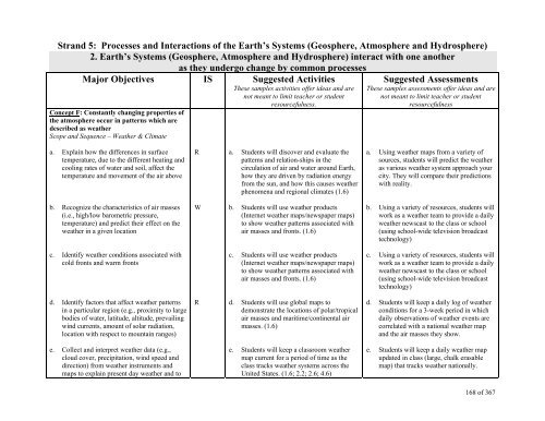
Strand 5: Processes and Interactions of the Earth’s Systems (Geosphere, Atmosphere and Hydrosphere)<br />
2. Earth’s Systems (Geosphere, Atmosphere and Hydrosphere) interact with one another<br />
as they undergo change by common processes<br />
Major Objectives IS Suggested Activities<br />
These samples activities offer ideas and are<br />
not meant to limit teacher or student<br />
Concept F: Constantly changing properties of<br />
the atmosphere occur in patterns which are<br />
described as weather<br />
Scope and Sequence – Weather & Climate<br />
resourcefulness.<br />
Suggested Assessments<br />
These samples assessments offer ideas and are<br />
not meant to limit teacher or student<br />
resourcefulness<br />
a. Explain how the differences in surface<br />
temperature, due to the different heating and<br />
cooling rates of water and soil, affect the<br />
temperature and movement of the air above<br />
R<br />
a. Students will discover and evaluate the<br />
patterns and relation-ships in the<br />
circulation of air and water around Earth,<br />
how they are driven by radiation energy<br />
from the sun, and how this causes weather<br />
phenomena and regional climates (1.6)<br />
a. Using weather maps from a variety of<br />
sources, students will predict the weather<br />
as various weather system approach your<br />
city. They will compare their predictions<br />
with reality.<br />
b. Recognize the characteristics of air masses<br />
(i.e., high/low barometric pressure,<br />
temperature) and predict their effect on the<br />
weather in a given location<br />
W<br />
b. Students will use weather products<br />
(Internet weather maps/newspaper maps)<br />
to show weather patterns associated with<br />
air masses and fronts. (1.6)<br />
b. Using a variety of resources, students will<br />
work as a weather team to provide a daily<br />
weather newscast to the class or school<br />
(using school-wide television broadcast<br />
technology)<br />
c. Identify weather conditions associated with<br />
cold fronts and warm fronts<br />
c. Students will use weather products<br />
(Internet weather maps/newspaper maps)<br />
to show weather patterns associated with<br />
air masses and fronts. (1.6)<br />
c. Using a variety of resources, students will<br />
work as a weather team to provide a daily<br />
weather newscast to the class or school<br />
(using school-wide television broadcast<br />
technology)<br />
d. Identify factors that affect weather patterns<br />
in a particular region (e.g., proximity to large<br />
bodies of water, latitude, altitude, prevailing<br />
wind currents, amount of solar radiation,<br />
location with respect to mountain ranges)<br />
R<br />
d. Students will use global maps to<br />
demonstrate the locations of polar/tropical<br />
air masses and maritime/continental air<br />
masses. (1.6)<br />
d. Students will keep a daily log of weather<br />
conditions for a 3-week period in which<br />
daily observations of weather events are<br />
correlated with a national weather map<br />
and the air masses they show.<br />
e. Collect and interpret weather data (e.g.,<br />
cloud cover, precipitation, wind speed and<br />
direction) from weather instruments and<br />
maps to explain present day weather and to<br />
e. Students will keep a classroom weather<br />
map current for a period of time as the<br />
class tracks weather systems across the<br />
United States. (1.6; 2.2; 2.6; 4.6)<br />
e. Students will keep a daily weather map<br />
updated in class (large, chalk erasable<br />
map) that tracks weather nationally.<br />
168 of 367