Northeast Subsistence-Settlement Change: A.D. 700 –1300
Northeast Subsistence-Settlement Change: A.D. 700 –1300
Northeast Subsistence-Settlement Change: A.D. 700 –1300

You also want an ePaper? Increase the reach of your titles
YUMPU automatically turns print PDFs into web optimized ePapers that Google loves.
segment of the terrace that effectively pinches the river<br />
bar into two separate flats. The soil at this locale is a<br />
fine sandy loam overlying heavier clay subsoil with an<br />
overburden of 10 cm of humus. Artifacts from the 2 m<br />
test unit include chert tools, cord-wrapped stick-decorated<br />
pottery, animal remains, and historic European<br />
materials. Two pits contained diagnostic Princess Point<br />
ceramics.<br />
The Forster Site (AgGx-134)<br />
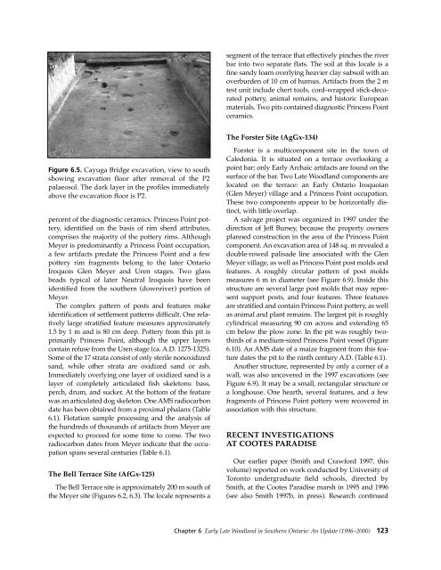
Figure 6.5. Cayuga Bridge excavation, view to south<br />
showing excavation floor after removal of the P2<br />
palaeosol. The dark layer in the profiles immediately<br />
above the excavation floor is P2.<br />
percent of the diagnostic ceramics. Princess Point pottery,<br />
identified on the basis of rim sherd attributes,<br />
comprises the majority of the pottery rims. Although<br />
Meyer is predominantly a Princess Point occupation,<br />
a few artifacts predate the Princess Point and a few<br />
pottery rim fragments belong to the later Ontario<br />
Iroquois Glen Meyer and Uren stages. Two glass<br />
beads typical of later Neutral Iroquois have been<br />
identified from the southern (downriver) portion of<br />
Meyer.<br />
The complex pattern of posts and features make<br />
identification of settlement patterns difficult. One relatively<br />
large stratified feature measures approximately<br />
1.5 by 1 m and is 80 cm deep. Pottery from this pit is<br />
primarily Princess Point, although the upper layers<br />
contain refuse from the Uren stage (ca. A.D. 1275-1325).<br />
Some of the 17 strata consist of only sterile nonoxidized<br />
sand, while other strata are oxidized sand or ash.<br />
Immediately overlying one layer of oxidized sand is a<br />
layer of completely articulated fish skeletons: bass,<br />
perch, drum, and sucker. At the bottom of the feature<br />
was an articulated dog skeleton. One AMS radiocarbon<br />
date has been obtained from a proximal phalanx (Table<br />
6.1). Flotation sample processing and the analysis of<br />
the hundreds of thousands of artifacts from Meyer are<br />
expected to proceed for some time to come. The two<br />
radiocarbon dates from Meyer indicate that the occupation<br />
spans several centuries (Table 6.1).<br />
The Bell Terrace Site (AfGx-125)<br />
The Bell Terrace site is approximately 200 m south of<br />
the Meyer site (Figures 6.2, 6.3). The locale represents a<br />
Forster is a multicomponent site in the town of<br />
Caledonia. It is situated on a terrace overlooking a<br />
point bar; only Early Archaic artifacts are found on the<br />
surface of the bar. Two Late Woodland components are<br />
located on the terrace: an Early Ontario Iroquoian<br />
(Glen Meyer) village and a Princess Point occupation.<br />
These two components appear to be horizontally distinct,<br />
with little overlap.<br />
A salvage project was organized in 1997 under the<br />
direction of Jeff Bursey, because the property owners<br />
planned construction in the area of the Princess Point<br />
component. An excavation area of 148 sq. m revealed a<br />
double-rowed palisade line associated with the Glen<br />
Meyer village, as well as Princess Point post molds and<br />
features. A roughly circular pattern of post molds<br />
measures 6 m in diameter (see Figure 6.9). Inside this<br />
structure are several large post molds that may represent<br />
support posts, and four features. Three features<br />
are stratified and contain Princess Point pottery, as well<br />
as animal and plant remains. The largest pit is roughly<br />
cylindrical measuring 90 cm across and extending 65<br />
cm below the plow zone. In the pit was roughly twothirds<br />
of a medium-sized Princess Point vessel (Figure<br />
6.10). An AMS date of a maize fragment from this feature<br />
dates the pit to the ninth century A.D. (Table 6.1).<br />
Another structure, represented by only a corner of a<br />
wall, was also uncovered in the 1997 excavations (see<br />
Figure 6.9). It may be a small, rectangular structure or<br />
a longhouse. One hearth, several features, and a few<br />
fragments of Princess Point pottery were recovered in<br />
association with this structure.<br />
RECENT INVESTIGATIONS<br />
AT COOTES PARADISE<br />
Our earlier paper (Smith and Crawford 1997, this<br />
volume) reported on work conducted by University of<br />
Toronto undergraduate field schools, directed by<br />
Smith, at the Cootes Paradise marsh in 1995 and 1996<br />
(see also Smith 1997b, in press). Research continued<br />
Chapter 6 Early Late Woodland in Southern Ontario: An Update (1996–2000) 123