Northeast Subsistence-Settlement Change: A.D. 700 –1300
Northeast Subsistence-Settlement Change: A.D. 700 –1300
Northeast Subsistence-Settlement Change: A.D. 700 –1300

You also want an ePaper? Increase the reach of your titles
YUMPU automatically turns print PDFs into web optimized ePapers that Google loves.
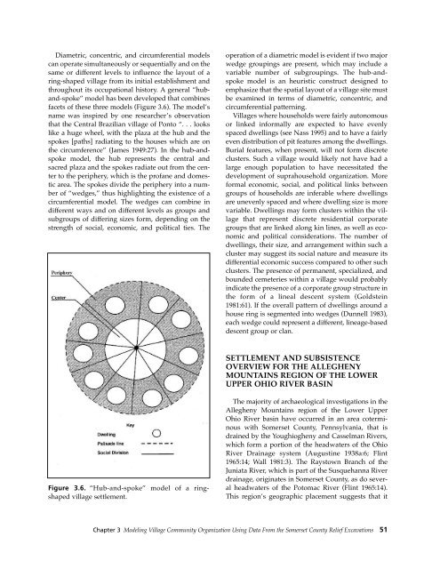
Diametric, concentric, and circumferential models<br />
can operate simultaneously or sequentially and on the<br />
same or different levels to influence the layout of a<br />
ring-shaped village from its initial establishment and<br />
throughout its occupational history. A general “huband-spoke”<br />
model has been developed that combines<br />
facets of these three models (Figure 3.6). The model’s<br />
name was inspired by one researcher’s observation<br />
that the Central Brazilian village of Ponto “. . . looks<br />
like a huge wheel, with the plaza at the hub and the<br />
spokes [paths] radiating to the houses which are on<br />
the circumference” (James 1949:27). In the hub-andspoke<br />
model, the hub represents the central and<br />
sacred plaza and the spokes radiate out from the center<br />
to the periphery, which is the profane and domestic<br />
area. The spokes divide the periphery into a number<br />
of “wedges,” thus highlighting the existence of a<br />
circumferential model. The wedges can combine in<br />
different ways and on different levels as groups and<br />
subgroups of differing sizes form, depending on the<br />
strength of social, economic, and political ties. The<br />
operation of a diametric model is evident if two major<br />
wedge groupings are present, which may include a<br />
variable number of subgroupings. The hub-andspoke<br />
model is an heuristic construct designed to<br />
emphasize that the spatial layout of a village site must<br />
be examined in terms of diametric, concentric, and<br />
circumferential patterning.<br />
Villages where households were fairly autonomous<br />
or linked informally are expected to have evenly<br />
spaced dwellings (see Nass 1995) and to have a fairly<br />
even distribution of pit features among the dwellings.<br />
Burial features, when present, will not form discrete<br />
clusters. Such a village would likely not have had a<br />
large enough population to have necessitated the<br />
development of suprahousehold organization. More<br />
formal economic, social, and political links between<br />
groups of households are inferable where dwellings<br />
are unevenly spaced and where dwelling size is more<br />
variable. Dwellings may form clusters within the village<br />
that represent discrete residential corporate<br />
groups that are linked along kin lines, as well as economic<br />
and political considerations. The number of<br />
dwellings, their size, and arrangement within such a<br />
cluster may suggest its social nature and measure its<br />
differential economic success compared to other such<br />
clusters. The presence of permanent, specialized, and<br />
bounded cemeteries within a village would probably<br />
indicate the presence of a corporate group structure in<br />
the form of a lineal descent system (Goldstein<br />
1981:61). If the overall pattern of dwellings around a<br />
house ring is segmented into wedges (Dunnell 1983),<br />
each wedge could represent a different, lineage-based<br />
descent group or clan.<br />
SETTLEMENT AND SUBSISTENCE<br />
OVERVIEW FOR THE ALLEGHENY<br />
MOUNTAINS REGION OF THE LOWER<br />
UPPER OHIO RIVER BASIN<br />
Figure 3.6. “Hub-and-spoke” model of a ringshaped<br />
village settlement.<br />
The majority of archaeological investigations in the<br />
Allegheny Mountains region of the Lower Upper<br />
Ohio River basin have occurred in an area coterminous<br />
with Somerset County, Pennsylvania, that is<br />
drained by the Youghiogheny and Casselman Rivers,<br />
which form a portion of the headwaters of the Ohio<br />
River Drainage system (Augustine 1938a:6; Flint<br />
1965:14; Wall 1981:3). The Raystown Branch of the<br />
Juniata River, which is part of the Susquehanna River<br />
drainage, originates in Somerset County, as do several<br />
headwaters of the Potomac River (Flint 1965:14).<br />
This region’s geographic placement suggests that it<br />
Chapter 3 Modeling Village Community Organization Using Data From the Somerset County Relief Excavations 51