Northeast Subsistence-Settlement Change: A.D. 700 –1300
Northeast Subsistence-Settlement Change: A.D. 700 –1300
Northeast Subsistence-Settlement Change: A.D. 700 –1300

You also want an ePaper? Increase the reach of your titles
YUMPU automatically turns print PDFs into web optimized ePapers that Google loves.
Olentangy River and other minor tributaries of the<br />
Scioto. DECCO and Hartley Farm may represent<br />
habitations, while Walter S. Cole and Ufferman<br />
appear to be specialized mortuary sites. The Scioto<br />
Woods site, also within this size range, and located<br />
just west of the Hartley Farm site on a small bench<br />
overlooking the same stream, has been interpreted as<br />
a lithic workshop (Church 1992).<br />
Farther south and to the southeast, the settlement<br />
picture differs somewhat. The Sabre Farms and<br />
Continental Construction sites also are located on the<br />
floodplain, but both are multi-component sites<br />
approximately 0.5 ha in size. Controlled surface collection<br />
at the Sabre Farms site delineated a linear surface<br />
scatter of Late Archaic, Early Woodland, and Late<br />
Woodland artifacts covering an area approximately 35<br />
meters by 130 meters along a north-south-trending<br />
rise on the Scioto River floodplain. Excavation of a 5<br />
meter-wide right-of-way across a segment of the surface<br />
scatter revealed a cluster of late Late Woodland<br />
shallow and deep basin pits, one large, deep storage<br />
pit; hearths; FCR concentrations; poorly preserved pit<br />
burials; and midden (Nass et al. 1990) (Figure 2.5).<br />
Artifacts place the site within the Peters phase<br />
(Seeman 1992a). Salvage excavation at the<br />
Continental Construction site (Pacheco 1987) revealed<br />
pit features containing late Late Woodland Peters<br />
phase ceramics, but no evidence of midden development.<br />
Again, pit features were located along a rise on<br />
the Scioto River floodplain.<br />
At the same time, excavation of a number of wellknown<br />
rockshelters in the uplands of south-central<br />
Ohio has revealed evidence of extensive use during<br />
this period. The Peters (Prufer and McKenzie 1966)<br />
and Chesser (Prufer 1975) rockshelters may represent<br />
the cold weather equivalent of the warm weather<br />
floodplain and terrace occupations.<br />
Along the Muskingum River, Philo II and the<br />
Longacre sites, located 3 kilometers upriver from<br />
Hunter 1, contain discrete clusters of pit features and<br />
artifacts attributable to the late Late Woodland (Morton<br />
1984). Components are approximately 3 ha in size for<br />
these and other late Late Woodland settlements, but<br />
may be due more to repeated occupational usage<br />
rather than a single, long-term occupation (cf. Seeman<br />
1992a, b; Shott and Jefferies 1992). The toolkit during<br />
this time contains limestone and chert-tempered, subconical<br />
ceramic jars; Raccoon Notched, Jacks Reef, and<br />
a small number of triangular points; bifacial knives,<br />
drills, scrapers; and ground stone celts, pitted cobbles,<br />
and hammerstones. The change in projectile point<br />
types from Chesser Notched and Lowe series points to<br />
Raccoon Notched, Jacks Reef, and triangular point<br />
types has been interpreted as a technological adaptation<br />
to the use of the bow and arrow in the region<br />
(Seeman 1992; Yerkes and Pecora 1991). No artifacts<br />
that could be interpreted as hoes have been found at<br />
any Ohio sites, but stone hoes made from sandstone<br />
have been recovered from West Virginia sites. Locally<br />
available raw materials dominated the chipped stone<br />
and expedient tool technology (Nass et al. 1990;<br />
Seeman 1992b; Shott and Jefferies 1990).<br />
Associated features (Figure 2.6) consist of shallow<br />
basin and shallow flat-bottom-shaped pits that<br />
ranged from 27 to 240 liters in volume, and occasionally<br />
sheet midden remnants. With the exception of a<br />
large deep-pit feature at Sabre Farms, which exceeds<br />
3,000 liters in volume, deep-cylinder and bell-shaped<br />
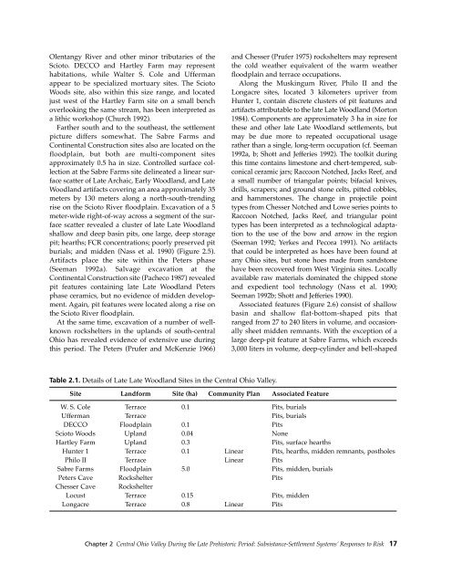
Table 2.1. Details of Late Late Woodland Sites in the Central Ohio Valley.<br />
Site Landform Site (ha) Community Plan Associated Feature<br />
W. S. Cole Terrace 0.1 Pits, burials<br />
Ufferman Terrace Pits, burials<br />
DECCO Floodplain 0.1 Pits<br />
Scioto Woods Upland 0.04 None<br />
Hartley Farm Upland 0.3 Pits, surface hearths<br />
Hunter 1 Terrace 0.1 Linear Pits, hearths, midden remnants, postholes<br />
Philo II Terrace Linear Pits<br />
Sabre Farms Floodplain 5.0 Pits, midden, burials<br />
Peters Cave Rockshelter Pits<br />
Chesser Cave Rockshelter<br />
Locust Terrace 0.15 Pits, midden<br />
Longacre Terrace 0.8 Linear Pits<br />
Chapter 2 Central Ohio Valley During the Late Prehistoric Period: Subsistance-<strong>Settlement</strong> Systems’ Responses to Risk 17