Global Report on Human Settlements 2007 - PoA-ISS
Global Report on Human Settlements 2007 - PoA-ISS
Global Report on Human Settlements 2007 - PoA-ISS

You also want an ePaper? Increase the reach of your titles
YUMPU automatically turns print PDFs into web optimized ePapers that Google loves.
200<br />
Natural and human-made disasters<br />
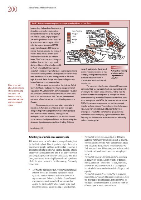
Box 8.5 Risk assessment strengthens local capacity and resilience in Lima, Peru<br />
Risk, in any <strong>on</strong>e<br />
place, is an outcome<br />
of decisi<strong>on</strong>-making<br />
and acti<strong>on</strong> – or<br />
inacti<strong>on</strong>- at local,<br />
municipal, nati<strong>on</strong>al<br />
and internati<strong>on</strong>al<br />
scales<br />
Located al<strong>on</strong>g the boundary of two tect<strong>on</strong>ic<br />
plates, Lima is at risk from earthquakes,<br />
floods and landslides. One of the city’s highrisk<br />
z<strong>on</strong>es is Caquetá, a highly c<strong>on</strong>gested<br />
Good<br />
Very good<br />
area with large amounts of waste produced<br />
Average<br />
by street traders and an irregular rubbish<br />
Bad<br />
collecti<strong>on</strong> service. An estimated 15,500<br />
people live in Caquetá in 3000 formal and<br />
informal dwellings c<strong>on</strong>sisting of a mixture of<br />
wooden shacks and four- and five-storey<br />
c<strong>on</strong>crete frame/brick-infill and rendered<br />
houses. The Caquetá ravine, cut through by<br />
the Rimac River, is a site for a potentially<br />
deadly combinati<strong>on</strong> of hazard and vulnerability.<br />
Poorly enforced building and planning<br />
codes, high densities and rapid urbanizati<strong>on</strong> (due to its proximity to<br />
commercial locati<strong>on</strong>s) combine with frequent landslides to increase<br />
the vulnerability of the squatter housing perched <strong>on</strong> the ravine<br />
edge. As a result, shelter damage and collapse are frequent, with<br />
losses of investments and sometimes lives.<br />
A risk assessment was undertaken – jointly by the Oxford<br />
Centre for Disaster Studies and the Peruvian n<strong>on</strong>-governmental<br />
organizati<strong>on</strong> (NGO) Instituto Para la Democracia Local – to gather<br />
data <strong>on</strong> hazard, vulnerability and capacity to be used for the formulati<strong>on</strong><br />
of ‘risk reducti<strong>on</strong> acti<strong>on</strong> plans. Data was gathered <strong>on</strong> the<br />
ravine area, informal markets and a c<strong>on</strong>solidated squatter area in<br />
Caquetá.<br />
The assessment was undertaken using a combinati<strong>on</strong> of<br />
research tools. Participatory rural appraisal tools were applied<br />
during meetings with housing and market associati<strong>on</strong> representatives.<br />
Activities included community mapping; time-line<br />
development to link the accumulati<strong>on</strong> of risk with local disasters<br />
and recovery; the development of disaster matrices recording views<br />
of causes and possible soluti<strong>on</strong>s; and hazard ranking. Additi<strong>on</strong>al<br />
State of buildings<br />
Rio<br />
Rimac<br />
research tools included the review of<br />
existing research, preparati<strong>on</strong> of maps<br />
identifying building and infrastructure<br />
standards, and administrati<strong>on</strong> of<br />
questi<strong>on</strong>naires with households and<br />
organizati<strong>on</strong>s.<br />
Figure 8.2<br />
Participatory mapping<br />
of building quality:<br />
Caquetá ravine in<br />
Lima, Peru<br />
The assessment helped to build relati<strong>on</strong>s with key actors at<br />
community, NGO and municipality levels and, importantly, provided<br />
credibility for the initiative am<strong>on</strong>g authorities. Findings from the<br />
assessment and the relati<strong>on</strong>ships built up in the process led to a<br />
three-day workshop attended by 30 representatives of local associati<strong>on</strong>s,<br />
municipalities, local NGOs, the fire service and internati<strong>on</strong>al<br />
NGOs. Key problems were presented and participants scoped<br />
ideas for workable soluti<strong>on</strong>s. These included training for fire awareness,<br />
ravine improvement through lobbying, and informati<strong>on</strong><br />
exchange. As a result of the workshop, local groups, including<br />
communities and the municipality, began to communicate more<br />
frequently, and the importance of risk awareness and vulnerability<br />
reducti<strong>on</strong> was recognized.<br />
Source: Sanders<strong>on</strong>, 1997<br />
Challenges of urban risk assessments<br />
Risk assessments are undertaken at a range of scales, from<br />
the local to the global. There is great diversity in the target of<br />
assessments (people, buildings and the urban ec<strong>on</strong>omy), in<br />
the sources of data (interviews, existing datasets, satellite<br />
imagery or expert judgements) and in the degree to which<br />
they are participatory or extractive in collecting data. In all<br />
cases, assessments aim to simplify complicated experiences<br />
of risk in order to assist in decisi<strong>on</strong>-making. Complexity<br />
comes from:<br />
• The multiple hazards to which people are simultaneously<br />
exposed. Recent and frequently experienced hazard<br />
types may be more visible to assessors than others at<br />
any <strong>on</strong>e moment. Following the Indian Ocean Tsunami,<br />
many assessments of tsunami risk were undertaken<br />
despite the likelihood of a future tsunami being much<br />
lower than seas<strong>on</strong>al rainfall flooding or armed c<strong>on</strong>flict.<br />
• The multiple sectors that are at risk. It is difficult to<br />
aggregate vulnerability across sectors such as housing,<br />
communicati<strong>on</strong> networks, water and sanitati<strong>on</strong>, educati<strong>on</strong>,<br />
healthcare infrastructure, power networks, etc.<br />
Each sector will have different exposure and susceptibility<br />
to risk and capacities and resources for coping and<br />
recovery.<br />
• The multiple scales at which risk is felt and resp<strong>on</strong>ded<br />
to. Risk, in any <strong>on</strong>e place, is an outcome of decisi<strong>on</strong>making<br />
and acti<strong>on</strong> – or inacti<strong>on</strong> – at local, municipal,<br />
nati<strong>on</strong>al and internati<strong>on</strong>al scales. It is challenging to<br />
include all of these scales in the analysis of impacts and<br />
capacity.<br />
• The multiple assets to be accounted for in measuring<br />
vulnerability and capacity. This applies to all scales, from<br />
the individual to the urban scale. Some assets will be<br />
c<strong>on</strong>tingent up<strong>on</strong> the utilizati<strong>on</strong> of others and rarely are<br />
different types of assets commensurate.