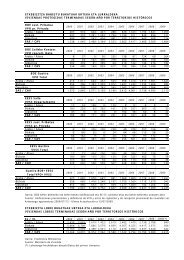
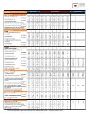
Estación Carretera Tipo P.K. Localidad más próxima CARRETERA A-2126: OYÓN / OION – BERNEDO. ÁLAVA EVOLUCIÓN DEL TRÁFICO EN LOS CORREDORES REPRESENTATIVOS DE LA RED COMARCAL IMD 2003 2002 2001 2000 1999 1998 1997 % Pesados IMD % Pesados IMD % Pesados IMD % Pesados IMD % Pesados IMD % Pesados IMD % Pesados 184 Variación (%) 1997 - 2003 IMD Pesados 470 A-2126 3 42,0 Puerto Bernedo 511 3,0 344 4,0 628 4,0 460 4,0 406 4,4 359 3,9 342 4,1 6,9 0,0 480 A-2126 3 53,5 Yécora 585 4,0 1.247 4,0 1.113 4,0 944 4,0 694 4,4 839 3,9 799 4,0 -5,1 -4,0 490 A-2126 1 59,1 Oyón (L.P. Logroño) 8.419 8,0 8.003 7,2 7.873 6,9 7.487 7,9 7.479 7,1 7.261 9,2 6.675 5,6 3,9 9,6 CARRETERA A-2128: SANTA CRUZ DE KANPEZO – SALVATIERRA. ÁLAVA 380 A-2128 2 27,3 Opacua 1.025 8,0 980 8,0 951 8,0 910 8,0 986 9,5 909 8,0 900 8,0 2,2 1,8 390 A-2128 3 38,0 Puerto Opacua 800 4,0 636 4,0 489 4,0 451 4,0 398 1,7 375 4,0 281 3,9 19,1 19,6 432 A-2128 3 39,4 Santa Cruz 410 5,0 311 5,0 258 5,0 283 5,0 208 5,5 305 4,9 207 4,8 12,1 12,4 400 A-2128 3 55,8 Contrasta 419 4,0 333 4,0 289 4,0 361 4,0 245 1,7 118 4,2 232 4,3 10,4 9,3 CARRETERA A-2124: VITORIA-GASTEIZ – LEZA. ÁLAVA 640 A-2124 3 3,7 Castillo 3.361 11,0 4.180 2,0 3.278 2,0 3.440 2,0 <strong>2.</strong>960 2,5 <strong>2.</strong>972 2,0 <strong>2.</strong>847 2,0 2,8 37,3 160 A-2124 1 9,5 Puerto Vitoria 3.904 10,0 3.493 1,6 3.648 1,9 3.433 1,9 3.262 5,7 3.380 2,1 3.226 1,8 3,2 38,0 630 A-2124 3 15,8 Peñacerrada (a Vitoria) 456 4,0 904 4,0 1.186 4,0 1.310 4,0 1.050 4,9 1.161 4,0 1.229 4,0 -15,2 -17,1 540 A-2124 2 26,0 Puerto Herrera 495 - 847 0,0 760 0,0 787 0,0 776 0,0 887 0,0 850 0,0 -8,6 - CARRETERA A-2130: ARETXABALETA – ASCARZA (VITORIA-GASTEIZ). ÁLAVA 170 A-2130 1 5,0 Otazu 3.438 6,0 3.184 5,2 3.179 5,1 <strong>2.</strong>811 5,6 <strong>2.</strong>913 5,0 <strong>2.</strong>916 4,25 <strong>2.</strong>225 9,0 7,5 0,3 CARRETERA A-2134: VITORIA-GASTEIZ. ÁLAVA 62 A-2134 1 7,9 Zurbano 4.528 18,0 3.822 20,6 3.324 26,3 3.643 23,3 <strong>2.</strong>594 30,9 <strong>2.</strong>399 26,6 <strong>2.</strong>531 11,0 10,2 19,6 CARRETERA A-2122: ZUBILLAGA – SOBRÓN. ÁLAVA 1170 A-2122 2 34,7 Zubil<strong>la</strong>ga 3.928 21,0 4.016 21,0 3.793 21,0 3.617 21,0 4.067 17,8 3.806 21,0 4.589 8,0 10,2 19,6 920 A-2122 3 42,8 Puente<strong>la</strong>rrá 1.952 16,0 1.794 21,0 1.889 21,0 1.713 21,0 <strong>2.</strong>157 20,2 1.746 21,0 <strong>2.</strong>108 7,0 10,2 19,6 921 A-2122 3 47,3 Sobrón 1.101 16,0 875 21,0 1.147 21,0 838 21,0 1.332 20,2 985 21,0 1.279 7,0 10,2 19,6 CARRETERA A-2622: NANCLARES DE OKA – LÍMITE CON BURGOS (GURENDES). ÁLAVA 670 A-2622 3 12,5 Nanc<strong>la</strong>res <strong>de</strong> <strong>la</strong> Oka 4.494 7,0 6.001 7,0 5.082 6,3 6.479 6,8 5.193 7,5 5.147 8,0 4.123 6,0 1,4 4,1 680 A-2622 1 16,5 Montevite <strong>2.</strong>459 4,0 <strong>2.</strong>265 4,9 <strong>2.</strong>296 5,5 <strong>2.</strong>075 20,7 1.984 4,4 <strong>2.</strong>171 5,2 1.781 3,8 5,5 7,4 700 A-2622 3 22,8 Paúl 903 5,0 1.126 4,9 853 5,0 1.780 20,7 707 4,2 877 5,1 673 3,9 5,0 8,6 1210 A-2622 3 33,5 Tuesta 1.131 5,0 871 7,0 1.248 7,0 769 7,0 875 4,2 783 6,9 698 7,2 8,4 2,7 740 A-2622 3 40,0 Guren<strong>de</strong>s 524 5,0 891 4,9 916 5,5 846 20,7 586 4,8 817 5,1 717 3,8 -5,1 -2,1 750 A-2622 3 51,5 Tobil<strong>la</strong>s 148 5,0 262 4,9 144 5,5 242 20,7 148 4,6 185 4,9 167 3,6 -2,0 2,6 CARRETERA A-2625: BERGÜENDA – ORDUÑA. ÁLAVA 722 A-2625 3 34,0 Cárcamo 133 8,0 228 10,0 185 10,0 430 10,0 221 7,1 133 9,8 147 6,1 -1,7 1,8 923 A-2625 3 318,9 Puente<strong>la</strong>rrá <strong>2.</strong>804 4,0 709 6,0 587 6,0 596 6,0 570 5,7 1.064 5,9 984 6,0 19,1 13,2 922 A-2625 3 321,0 Bergüenda 1.612 4,0 1.622 6,0 1.478 6,0 946 6,0 1.270 5,7 1.521 6,0 1.383 6,0 2,6 -2,3 Revisión <strong>de</strong>l Segundo P<strong>la</strong>n General <strong>de</strong> Carreteras <strong>de</strong>l País Vasco
Estación Carretera Tipo P.K. Localidad más próxima IMD 2003 2002 2001 2000 1999 1998 1997 % Pesados IMD % Pesados IMD % Pesados IMD % Pesados IMD % Pesados IMD % Pesados IMD % Pesados 185 Variación (%) 1997 - 2003 IMD Pesados 720 A-2625 1 334,8 Osma 1.221 4,0 1.048 4,8 1.026 5,4 1.163 5,4 750 10,7 697 10,0 722 6,1 9,2 1,8 721 A-2625 3 346,2 Puerto Orduña 808 4,0 1.136 6,0 622 6,0 508 6,0 544 4,9 539 5,9 528 6,1 7,3 1,9 CARRETERA A-2521: ALTUBE – ORDUÑA. ÁLAVA 830 A-2521 2 23,8 Beluntza <strong>2.</strong>415 11,0 <strong>2.</strong>503 11,0 <strong>2.</strong>160 11,0 1.923 11,0 1.636 9,1 1.656 11,0 1.413 10,0 9,3 10,8 760 A-2521 3 30,0 Unzá 780 5,0 773 6,0 636 6,0 622 6,0 563 5,4 613 5,9 966 6,0 -3,5 -6,0 CARRETERA A-2604: GORDELIZ – LÍMITE CON BIZKAIA PASANDO POR ARTZINIEGA. ÁLAVA 900 A-2604 3 1,0 Gordéliz (Artziniega) 1.889 5,0 1.634 6,0 1.519 6,0 1.446 6,0 1.003 5,4 938 6,0 893 6,0 13,3 11,1 902 A-2604 3 4,5 Gordéliz (Peña Angulo) 654 4,0 864 5,0 848 5,0 667 5,0 623 4,5 615 5,0 410 8,0 8,1 -2,0 850 A-2604 1 55,5 Artziniega <strong>2.</strong>960 8,0 <strong>2.</strong>862 8,4 <strong>2.</strong>764 8,4 <strong>2.</strong>545 8,4 <strong>2.</strong>706 7,8 <strong>2.</strong>723 7,4 1.401 4,0 13,3 26,8 CARRETERA BI-2604: SODUPE - LÍMITE CON ÁLAVA –. BIZKAIA 72 C BI-2604 2 - Gor<strong>de</strong>xo<strong>la</strong> – L.P. (Artziniega) <strong>2.</strong>924 6,0 <strong>2.</strong>834 6,0 <strong>2.</strong>881 6,0 <strong>2.</strong>845 6,0 <strong>2.</strong>577 6,0 <strong>2.</strong>605 6,0 <strong>2.</strong>439 6,0 3,1 3,1 72 A BI-2604 3 - Gor<strong>de</strong>xo<strong>la</strong> – Padura (Sodupe) 4.124 8,0 4.016 8,0 3.899 8,0 3.781 8,0 3.702 8,0 3.566 8,0 3.525 8,0 2,7 2,7 57 B BI-2604 3 - Sodupe - Padura 4.914 4,0 5.096 4,0 6.244 4,0 6.542 4,0 6.234 4,0 5.973 4,0 5.889 4,0 -3,0 -3,0 CARRETERA A-252<strong>2.</strong> ZIORRAGA – LÍMITE CON BIZKAIA. ÁLAVA 800 A-2522 3 34,3 Baranbio 1.724 5,0 1.709 10,0 1.613 10,0 1.832 10,0 1.645 4,6 <strong>2.</strong>721 10,0 <strong>2.</strong>569 10,0 -6,4 -17,8 790 A-2522 1 36,6 Ziorraga 1.744 15,0 1.922 13,8 1.953 15,1 <strong>2.</strong>038 16,5 <strong>2.</strong>238 12,4 <strong>2.</strong>727 11,6 1.955 17,6 -1,9 -5,0 791 A-2522 3 47,0 Llodio (Orozco) 6.459 7,0 5.601 10,0 6.212 10,0 5.844 10,0 4.732 4,6 5.321 10,0 5.137 10,0 3,9 -1,3 CARRETERA BI-2522: LLODIO - LÍMITE CON ÁLAVA –. BIZKAIA 177 A BI-2522 2 - Orozko – L.P. (Ziorraga) <strong>2.</strong>065 8,0 <strong>2.</strong>310 8,0 <strong>2.</strong>446 8,0 <strong>2.</strong>608 8,0 <strong>2.</strong>818 8,0 <strong>2.</strong>711 8,0 <strong>2.</strong>322 8,0 -1,9 -1,9 177 C BI-2522 2 - E. Areta Sur - Orozko 5.351 7,0 5.762 7,0 5.532 7,0 5.549 7,0 5.727 7,0 5.540 7,0 4.859 4,0 1,6 11,6 159 A BI-2522 2 - Areta – E. Areta Sur 5.951 10,0 6.392 10,0 6.117 10,0 6.215 10,0 6.676 10,0 6.810 10,0 5.836 10,0 0,3 0,3 CARRETERA A-2620: LEGUTIANO – ARRASATE / MONDRAGÓN. ÁLAVA 320 A-2620 2 17,3 Puerto Cruceta 944 5,0 774 4,0 759 4,0 850 4,0 800 3,1 827 4,0 751 4,0 3,9 6,6 450 A-2620 3 31,2 Ibarra <strong>de</strong> Aramaio <strong>2.</strong>803 5,0 <strong>2.</strong>919 8,0 <strong>2.</strong>823 8,0 <strong>2.</strong>768 8,0 <strong>2.</strong>054 5,6 1.345 8,0 1.720 8,0 8,5 1,2 CARRETERA GI-2120 (Antigua GI-120): ESTELLA - BEASAIN. GIPUZKOA 64 GI-2120 3 49,2 Alto <strong>de</strong> Lizarrusti 343 14,0 761 - 750 - 631 - 1.447 - 495 - 664 - -10,4 - 97 GI-2120 2 62,0 Puente Nuevo Ataun 3.473 8,0 3702 8,0 3.805 9,0 3.813 8,0 3.528 - 3.154 - 3.071 - 2,1 - 1314 GI-2120 3 63,4 Variante <strong>de</strong> Lazkao 7.255 11,0 6.075 - 7.514 - 5.704 - 5.084 - 4.514 - 3.167 - 14,8 - CARRETERA GI-2620: ARRASATE / MONDRAGÓN – LÍMITE CON ÁLAVA. GIPUZKOA 95 GI-2620 3 16,6 Santa Ageda <strong>2.</strong>223 - 1.926 - <strong>2.</strong>242 - <strong>2.</strong>166 - <strong>2.</strong>481 - 1.549 - 1.241 - 10,2 - 94 GI-2620 3 19 Arrasate / Mondragón 6.961 - 5.458 - 6.937 - 7.082 - 6.258 - 6.368 - 5.826 - 3,0 - 53 GI-2620 3 22,2 Arrasate / Mondragón 14.716 - 13.122 - 15.314 - 15.603 - 13.736 - 13.218 - 1<strong>2.</strong>594 - 2,6 - CARRETERA GI-2630: ZUMARRAGA – ARRASATE / MONDRAGÓN. GIPUZKOA 9259 GI-2630 3 0,3 Urretxu 11.893 - 11.801 - 11.230 - 11.528 - 15.409 - 10.711 - 8.252 - 6,3 - Revisión <strong>de</strong>l Segundo P<strong>la</strong>n General <strong>de</strong> Carreteras <strong>de</strong>l País Vasco
- Page 1 and 2:
2. ANÁLISIS DE LA SITUACIÓN ACTUA
- Page 3 and 4:
DISTRIBUCIÓN DE LA LONGITUD DE CAR
- Page 5 and 6:
En lo que se refiere a la Red de In
- Page 7 and 8:
DISTRIBUCIÓN DE LA RED BÁSICA SEG
- Page 9 and 10:
2,0 1,8 1,6 1,4 1,2 1,0 0,8 0,6 0,4
- Page 11 and 12:
RED OBJETO DE LA COMUNIDAD AUTÓNOM
- Page 13 and 14:
A la vista de estos datos de la Red
- Page 15 and 16:
0,25 0,20 0,15 0,10 0,05 0,00 DENSI
- Page 17 and 18:
Carretera N-622: de Vitoria-Gasteiz
- Page 19 and 20:
√ P.K. 18 a 30; radios inferiores
- Page 21 and 22:
Carretera Red de Interés Preferent
- Page 23 and 24:
2.1.2.3. Velocidades específicas A
- Page 26 and 27:
2.1.2.4. Caídas de Velocidad La p
- Page 29 and 30:
2.1.3 Radios de Curvatura El trazad
- Page 31 and 32:
Radios de Curvatura del Territorio
- Page 33 and 34:
Radios de Curvatura del Territorio
- Page 38 and 39:
2.1.4 Sección transversal 2.1.4.1.
- Page 40 and 41:
NÚMERO DE CARRILES EN LAS CARRETER
- Page 42 and 43:
NÚMERO DE CARRILES EN LAS AUTOPIST
- Page 44 and 45:
NÚMERO DE CARRILES EN LAS CARRETER
- Page 47 and 48:
2.1.4.2. Anchos de plataforma El es
- Page 49 and 50:
Anchos de Plataforma del Territorio
- Page 51 and 52:
Finalmente, en la Red Comarcal de B
- Page 53 and 54:
ANCHOS DE PLATAFORMA EN LAS CARRETE
- Page 58 and 59:
2.1.5 Posibilidad de adelantamiento
- Page 60:
Tal y como se observa en la gráfic
- Page 63 and 64:
DISTRIBUCIÓN DEL TOTAL DE ACCIDENT
- Page 65 and 66:
LESIVIDAD EN LAS CARRETERAS DE LA R
- Page 67 and 68:
Territorio Histórico de Álava ACC
- Page 69 and 70:
Territorio Histórico de Bizkaia AC
- Page 71 and 72:
Tipo de accidente Absoluto 1999 200
- Page 73 and 74:
DISTRIBUCIÓN DE ACCIDENTES SEGÚN
- Page 75 and 76:
En el conjunto de las carreteras de
- Page 77 and 78:
ACCIDENTES CON VÍCTIMAS SEGÚN MES
- Page 79 and 80:
ACCIDENTES SEGÚN MES EN LAS CARRET
- Page 81 and 82:
Carretera Accidentes con Víctimas
- Page 83 and 84:
Carretera Accidentes con Víctimas
- Page 85 and 86:
Carretera Accidentes con Víctimas
- Page 87 and 88:
Carretera Accidentes con Víctimas
- Page 89 and 90:
Carretera Accidentes con Víctimas
- Page 91 and 92:
EVOLUCIÓN DEL NÚMERO DE ACCIDENTE
- Page 93 and 94:
2.1.6.8. Accidentes por kilómetro
- Page 95 and 96:
Carretera Accidentes con Víctimas
- Page 97 and 98:
ACCIDENTES CON VÍCTIMAS POR KILÓM
- Page 99 and 100:
ACCIDENTES POR KILÓMETRO EN LA RED
- Page 101 and 102:
AUTOPISTAS, AUTOVÍAS Y CARRETERAS
- Page 103 and 104:
DISTRIBUCIÓN DE TCA POR RANGOS DE
- Page 105:
TCA EN LAS CARRETERAS DE LA RED FUN
- Page 108 and 109:
INTERSECCIONES SEGÚN TIPOLOGÍA EN
- Page 111 and 112:
2.1.7.2. Red Funcional Además del
- Page 113 and 114:
INTERSECCIONES POR KILÓMETRO EN LA
- Page 115 and 116:
√ Número de semáforos. √ Núm
- Page 117 and 118:
TRAVESÍAS DE CONFLICTIVIDAD ALTA E
- Page 119 and 120:
TRAVESÍAS DE CONFLICTIVIDAD ALTA E
- Page 121:
La distribución de TCAs en traves
- Page 124 and 125:
A continuación se presenta la evol
- Page 126 and 127: En la siguiente tabla se presentan
- Page 128 and 129: Estación Carretera Tipo P.K. Local
- Page 130 and 131: Estación Carretera Tipo P.K. Local
- Page 132 and 133: Estación Carretera Tipo P.K. Local
- Page 134 and 135: Estación Carretera Tipo P.K. Local
- Page 136 and 137: Por su parte, aquellas carreteras d
- Page 138 and 139: 20.00% 18.00% 16.00% 14.00% 12.00%
- Page 140 and 141: INTENSIDAD DE PESADOS EN LA CARRETE
- Page 142 and 143: INTENSIDAD DE PESADOS EN LA CARRETE
- Page 144 and 145: PORCENTAJE DE PESADOS EN LA CARRETE
- Page 146 and 147: PORCENTAJE DE PESADOS EN LA CARRETE
- Page 148 and 149: El acceso al Aeropuerto de Loiu, en
- Page 150 and 151: Estación Carretera Tipo P.K. Local
- Page 152 and 153: Estación Carretera Tipo P.K. Local
- Page 154 and 155: Estación Carretera Tipo P.K. Local
- Page 156 and 157: Se presenta a continuación un grá
- Page 158 and 159: 4,500 4,000 3,500 3,000 2,500 2,000
- Page 160 and 161: INTENSIDAD DE TRÁFICO EN LA CARRET
- Page 162 and 163: INTENSIDAD DE TRÁFICO EN LA CARRET
- Page 164 and 165: INTENSIDAD DE TRÁFICO EN LA CARRET
- Page 166 and 167: 40.000 35.000 30.000 25.000 20.000
- Page 168 and 169: INTENSIDAD DE TRÁFICO EN LA CARRET
- Page 170 and 171: INTENSIDAD DE TRÁFICO EN LA CARRET
- Page 172 and 173: INTENSIDAD DE TRÁFICO EN LAS CARRE
- Page 174 and 175: INTENSIDAD DE TRÁFICO EN LAS CARRE
- Page 178 and 179: Estación Carretera Tipo P.K. Local
- Page 180 and 181: Estación Carretera Tipo P.K. Local
- Page 182 and 183: FLUJOS TOTALES DE TRÁFICO EN LA RE
- Page 184 and 185: Estación Carretera P.K. Localidad
- Page 186 and 187: Estación Carretera P.K. Localidad
- Page 188 and 189: Estación Carretera P.K. Localidad
- Page 190 and 191: De manera análoga al análisis ant
- Page 192 and 193: Estación Carretera P.K. Localidad
- Page 194 and 195: Estación Carretera P.K. Localidad
- Page 196 and 197: Estación Carretera P.K. Localidad
- Page 198 and 199: Por último, de la Red Comarcal las
- Page 200 and 201: Estación Carretera P.K. Localidad
- Page 202 and 203: Estación Carretera P.K. Localidad
- Page 204 and 205: Estación Carretera P.K. Localidad
- Page 206 and 207: Estación Carretera P.K. Localidad
- Page 208 and 209: Estación Carretera P.K. Localidad
- Page 210 and 211: Estación Carretera P.K. Localidad
- Page 212 and 213: 40,00% 35,00% 30,00% 25,00% 20,00%
- Page 214 and 215: 25,00% 20,00% 15,00% 10,00% TRÁFIC
- Page 216 and 217: 80,00% 70,00% 60,00% 50,00% 40,00%
- Page 218 and 219: 2.2.2.6. Evolución del Tráfico se
- Page 223 and 224: 2.2.3 Capacidad de la red y niveles
- Page 225 and 226: Cuando el tráfico no está formado
- Page 227 and 228:
2.2.3.2. Situación actual en la Re
- Page 229 and 230:
Respecto al conjunto de la Comunida
- Page 231 and 232:
NIVEL DE SERVICIO EN EL TERRITORIO
- Page 234 and 235:
2.2.3.3. Resto de la Red Funcional
- Page 236 and 237:
2.3. CARACTERIZACIÓN DE LA MOVILID
- Page 238 and 239:
La cuota de reparto modal correspon
- Page 240 and 241:
2.3.1.2. Transporte de mercancías
- Page 242 and 243:
La cuota de reparto modal correspon
- Page 244 and 245:
2.3.2 Transporte por carretera 2.3.
- Page 246 and 247:
En el día medio del año 2003 la d
- Page 248 and 249:
Naturaleza del viaje TONELADAS TRAN
- Page 250 and 251:
Naturaleza del viaje EuskoTren Cer.
- Page 252 and 253:
√ Núcleo de Donostia-San Sebasti
- Page 254 and 255:
Naturaleza del viaje DEMANDA DE TRA
- Page 256 and 257:
2.4. LA MOVILIDAD EN LA RED FUNCION
- Page 258 and 259:
Origen Destino Itinerario Total Lig
- Page 260 and 261:
Origen Destino Itinerario Total Lig
- Page 262 and 263:
Origen Destino Itinerario Total Lig
- Page 264 and 265:
Origen Destino Itinerario Total Lig
- Page 266 and 267:
Por último, la matriz Origen / Des
- Page 268 and 269:
ESQUEMA METODOLÓGICO 276 Revisión
- Page 270 and 271:
PUNTOS DE CONTROL DE AFOROS. AÑO 2
- Page 272 and 273:
Origen Interno País Vasco Externo
- Page 274:
Zonificación Nombre Zona Zonificac
- Page 277 and 278:
√ Estratificación de la demanda
- Page 280:
2.5.6 Isocronas Con el fin de visua
- Page 289:
Las zonas que presentan mejor acces