2. análisis de la situación actual de la red viaria - Garraioak
2. análisis de la situación actual de la red viaria - Garraioak
2. análisis de la situación actual de la red viaria - Garraioak

Create successful ePaper yourself
Turn your PDF publications into a flip-book with our unique Google optimized e-Paper software.
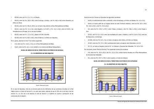
√ BI-604, entre los P.K. 2,3 y 7,4., en Deusto.<br />
√ BI-623, entre los P.K. 28,0 a 39,0, entre Durango y Urkio<strong>la</strong>; y <strong>de</strong> P.K. 48,0 a 49,0 entre Otxandio y el<br />
límite con Á<strong>la</strong>va.<br />
√ BI-625, entre los P.K. 381,8 y 387,4, en el tramo más próximo al Área Metropolitana <strong>de</strong> Bilbao.<br />
√ BI-631: entre los P.K. 5,2 a 9,0, entre Begoña y <strong>la</strong> N-637; y P.K. 12,2 a 18,9, entre <strong>la</strong> N-633 y <strong>la</strong>s<br />
inmediaciones <strong>de</strong> Mungia, al sur <strong>de</strong> esta localidad.<br />
√ BI-635, entre los P.K. 17,3 a 35,1, <strong>de</strong>s<strong>de</strong> <strong>la</strong> N-240 a Gernika.<br />
√ BI-638, entre los P.K. 68,0 y 69,0, entre Ondarroa y el límite con Gipuzkoa.<br />
Por su parte, alcanzan el nivel F los tramos siguientes:<br />
√ A-8, entre los P.K. 110,5 y 131,0, en el Área Metropolitana <strong>de</strong> Bilbao.<br />
√ N-637, entre los P.K. 8,5 y 12,0, también en el entorno <strong>de</strong>l Bilbao Metropolitano.<br />
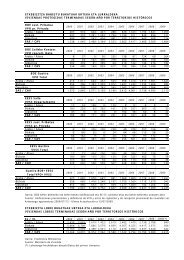
NIVEL DE SERVICIO EN EL TERRITORIO HISTÓRICO DE BIZKAIA<br />
0,40<br />
0,35<br />
0,30<br />
0,25<br />
0,20<br />
0,15<br />
0,10<br />
0,05<br />
0,00<br />
10%<br />
(% KILÓMETROS DE RED OBJETO)<br />
20%<br />
19%<br />
9%<br />
38%<br />
A B C D E F<br />
Fuente: E<strong>la</strong>boración propia<br />
En el caso <strong>de</strong> Gipuzkoa, más <strong>de</strong> una tercera parte <strong>de</strong> los kilómetros <strong>de</strong> sus carreteras incluidas en <strong>la</strong> Red<br />
Objeto tienen un Nivel <strong>de</strong> Servicio E y en este caso existe, a<strong>de</strong>más <strong>de</strong> que el 23% <strong>de</strong> <strong>la</strong> <strong>red</strong> tiene nivel <strong>de</strong><br />
servicio D y un 2% <strong>de</strong> <strong>la</strong> <strong>red</strong> alcanza el nivel <strong>de</strong> servicio F, el pésimo en cuanto a percepción <strong>de</strong> <strong>la</strong>s<br />
condiciones <strong>de</strong> circu<strong>la</strong>ción.<br />
5%<br />
Nivel <strong>de</strong> servicio E tienen en Gipuzkoa <strong>la</strong>s siguientes carreteras:<br />
√ N-636, en prácticamente toda su extensión, entre Ormaiztegi y el límite con Bizkaia, P.K. 4,5 a 35,<strong>2.</strong><br />
√ N-634, en buena parte <strong>de</strong> su longitud <strong>de</strong>ntro <strong>de</strong> este Territorio Histórico, entre los P.K. 0,0 a 19,0;<br />
P.K. 22,0 a 23,0; y <strong>de</strong>l P.K. 27,0 a 62,0.<br />
√ N-I, entre los P.K. 444,7 a 447,7, entre Tolosa y Andoain; y <strong>de</strong>l P.K. 466,3 a 481,5, entre Pasaia e<br />
Irun.<br />
√ GI-631, <strong>de</strong>l P.K. 8,2 a 18,9, entre <strong>la</strong>s localida<strong>de</strong>s <strong>de</strong> Lasao y Azkoitia; y <strong>de</strong>l P.K. 26,0 a 34,5, entre <strong>la</strong>s<br />
<strong>de</strong> Aizpurutxo y Zumarraga.<br />
√ GI-638, entre los P.K. 0,0 y 7,8, en toda su longitud, entre Deba y el límite con Bizkaia.<br />
√ GI-627, entre los P.K. 27,2 y 56,3, prácticamente toda su longitud, entre Eskoriatza y <strong>la</strong> A-8.<br />
√ GI–131, en toda su longitud, entre <strong>la</strong> N-I en Andoain y Donostia-San Sebastián, P.K. 0,0 a 15,0.<br />
Por otra parte, tienen Nivel <strong>de</strong> Servicio F los siguientes tramos <strong>de</strong> carreteras:<br />
√ A-8, entre los P.K. 18,0 a 20,0 y <strong>de</strong>l P.K. 22,5 a 23,0, ambos tramos situados en el Área Metropolitana<br />
<strong>de</strong> Donostia-San Sebastián.<br />
√ N-I, entre los P.K. 447,7 y 453,7, entre Lasarte y el norte <strong>de</strong> Andoain.<br />
NIVEL DE SERVICIO EN EL TERRITORIO HISTÓRICO DE GIPUZKOA<br />
40<br />
35<br />
30<br />
25<br />
20<br />
15<br />
10<br />
5<br />
0<br />
15%<br />
(% KILÓMETROS DE RED OBJETO)<br />
11%<br />
9%<br />
23%<br />
40%<br />
A B C D E F<br />
Fuente: E<strong>la</strong>boración propia<br />
2%<br />
236<br />
Revisión <strong>de</strong>l Segundo P<strong>la</strong>n General <strong>de</strong> Carreteras <strong>de</strong>l País Vasco