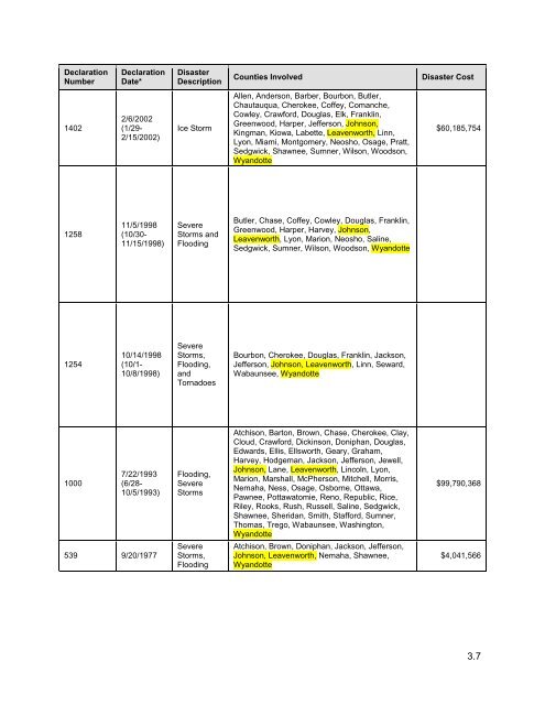
Declaration Number Declaration Date* Disaster Description Counties Involved Disaster Cost 1402 2/6/2002 (1/29- 2/15/2002) Ice Storm Allen, Anderson, Barber, Bourbon, Butler, Chautauqua, Cherokee, Coffey, Comanche, Cowley, Crawford, Douglas, Elk, Franklin, Greenwood, Harper, Jefferson, Johnson, Kingman, Kiowa, Labette, Leavenworth, Linn, Lyon, Miami, Montgomery, Neosho, Osage, Pratt, Sedgwick, Shawnee, Sumner, Wilson, Woodson, Wyandotte $60,185,754 1258 11/5/1998 (10/30- 11/15/1998) Severe Storms and Flooding Butler, Chase, Coffey, Cowley, Douglas, Franklin, Greenwood, Harper, Harvey, Johnson, Leavenworth, Lyon, Marion, Neosho, Saline, Sedgwick, Sumner, Wilson, Woodson, Wyandotte 1254 10/14/1998 (10/1- 10/8/1998) Severe Storms, Flooding, and Tornadoes Bourbon, Cherokee, Douglas, Franklin, Jackson, Jefferson, Johnson, Leavenworth, Linn, Seward, Wabaunsee, Wyandotte 1000 7/22/1993 (6/28- 10/5/1993) Flooding, Severe Storms Atchison, Barton, Brown, Chase, Cherokee, Clay, Cloud, Crawford, Dickinson, Doniphan, Douglas, Edwards, Ellis, Ellsworth, Geary, Graham, Harvey, Hodgeman, Jackson, Jefferson, Jewell, Johnson, Lane, Leavenworth, Lincoln, Lyon, Marion, Marshall, McPherson, Mitchell, Morris, Nemaha, Ness, Osage, Osborne, Ottawa, Pawnee, Pottawatomie, Reno, Republic, Rice, Riley, Rooks, Rush, Russell, Saline, Sedgwick, Shawnee, Sheridan, Smith, Stafford, Sumner, Thomas, Trego, Wabaunsee, Washington, Wyandotte $99,790,368 539 9/20/1977 Severe Storms, Flooding Atchison, Brown, Doniphan, Jackson, Jefferson, Johnson, Leavenworth, Nemaha, Shawnee, Wyandotte $4,041,566 3.7
Declaration Number Declaration Date* Disaster Description Counties Involved Disaster Cost 403 9/28/1973 Severe Storms, Tornadoes, Flooding Atchison, Barber, Barton, Brown, Butler, Chase, Clay, Cloud, Coffey, Comanche, Cowley, Dickinson, Doniphan, Douglas, Edwards, Ellsworth, Franklin, Geary, Greenwood, Harper, Harvey, Jackson, Jefferson, Kingman, Kiowa, Leavenworth, Lincoln, Linn, Lyon, Marion, Marshall, McPherson, Miami, Morris, Nemaha, Osage, Ottawa, Pawnee, Pottawatomie, Pratt, Reno, Republic, Rice, Riley, Saline, Sedgwick, Shawnee, Stafford, Sumner, Wabaunsee, Washington, Woodson, Wyandotte $4,296,913 378 5/2/1973 Severe Storms, Flooding Atchison, Barber, Barton, Bourbon, Brown, Butler, Chautauqua, Cherokee, Clark, Coffey, Crawford, Dickinson, Doniphan, Douglas, Edwards, Ellsworth, Ford, Franklin, Gray, Greenwood, Harper, Harvey, Haskell, Hodgeman, Jackson, Jefferson, Kingman, Kiowa, Labette, Leavenworth, Lincoln, Linn, Lyon, Marion, Marshall, McPherson, Meade, Miami, Montgomery , Morris, Nemaha, Ness, Osage, Osborne, Ottawa, Pawnee, Pottawatomie, Pratt, Reno, Republic, Rice, Rush, Russell, Saline, Sedgwick, Seward, Shawnee, Stafford, Stevens, Sumner, Wabaunsee, Washington, Woodson, Wyandotte $1,954,624 267 7/15/1969 229 7/18/1967 Tornadoes, Severe Storms, Flooding Tornadoes, Severe Storms, Flooding Allen, Anderson, Bourbon, Crawford, Dickinson, Douglas, Ellsworth, Franklin, Johnson, Leavenworth, Linn, Lyon, McPherson, Miami, Morris, Neosho, Osage, Saline, Woodson, Wyandotte Anderson, Atchison, Chase, Cloud, Coffey, Crawford, Doniphan, Douglas, Finney, Franklin, Harper, Jackson, Jefferson, Kingman, Leavenworth, Linn, Lyon, Marion, Miami, Mitchell, Nemaha, Ness, Osage, Pottawatomie, Republic, Washington, Wabaunsee $733,524 $847,439 Emergency Declarations 3324 6/25/2011 Flooding 3282 12/12/2007 3236 9/1/0/2005 Severe Winter Storms Hurricane Katrina Evacuation Atchison, Doniphan, Leavenworth and Wyandotte All All n/a n/a n/a Table 3.4 lists <strong>the</strong> U.S. Department of Agriculture Secretarial Disaster Declarations relevant to Region L for <strong>the</strong> period 2010 – 2012. Secretarial Disasters are designated from a natural disaster and require a minimum production loss of 30 percent for at least one crop. 3.8
- Page 1 and 2:
Region L Multi-Jurisdictional Hazar
- Page 3 and 4:
Executive Summary The Regional Haza
- Page 5 and 6:
• Goal 4: Enhance communication a
- Page 7 and 8:
2.3.1 Geography/Topography 2.73 2.3
- Page 9 and 10:
1 Introduction/Planning Process 1.1
- Page 11 and 12:
would not be a requirement but high
- Page 13 and 14:
Mission X X X Mission Hills X X X M
- Page 15 and 16:
committee member versus being a par
- Page 17 and 18:
Following are some of the public co
- Page 19 and 20:
Figure 1.4. Opportunity to Read HMP
- Page 21 and 22:
covered. While I don’t doubt the
- Page 23 and 24:
the planning area for flood and ear
- Page 25 and 26:
2.2
- Page 27 and 28:
Table 2.2. Housing Unit Gains 2000-
- Page 29 and 30:
Table 2.3. Estimated Replacement Va
- Page 31 and 32:
2.2 Johnson County History The firs
- Page 33 and 34:
2.2.2 Johnson County Climate Johnso
- Page 35 and 36:
INDUSTRY Estimated Employees % Info
- Page 37 and 38:
Table 2.8. Johnson County Administr
- Page 39 and 40:
Table 2.10. Johnson County Program
- Page 41 and 42:
• Mahaffie House 1100 Kansas City
- Page 43 and 44:
City of Edgerton Overview Edgerton
- Page 45 and 46:
• Administration • Finance •
- Page 47 and 48:
Land Use and Development Trends In
- Page 49 and 50:
• Taxes for specific purposes •
- Page 51 and 52:
Personnel Resources Yes/No Departme
- Page 53 and 54:
Personnel Resources Yes/No Departme
- Page 55 and 56:
Administer, as well as eight city c
- Page 57 and 58:
• Capital Improvements Project Fu
- Page 59 and 60:
Existing Plans and Policies The Cit
- Page 61 and 62:
Property Valuation Table 2.22 below
- Page 63 and 64:
• Local Recovery Plan • County
- Page 65 and 66:
Team Hazardous Materials Expert Yes
- Page 67 and 68:
Technical and Fiscal Resources Tool
- Page 69 and 70:
Personnel Resources Yes/No Departme
- Page 71 and 72:
Table 2.19. City of Shawnee Personn
- Page 73 and 74:
a mayor/city council form of govern
- Page 75 and 76:
City of Westwood Westwood is situat
- Page 77 and 78:
• Withholding spending in hazard
- Page 79 and 80:
Fiscal resources that the district
- Page 81 and 82:
U.S.D. 230 Spring Hill USD 230 serv
- Page 83 and 84:
Existing Plans and Policies In part
- Page 85 and 86:
U.S.D. 233 Olathe USD 233 serves Ol
- Page 87 and 88:
School Olathe North High 600 E Prai
- Page 89 and 90:
Crestview Elementary School trailer
- Page 91 and 92:
Specialist serves as the Emergency
- Page 93 and 94:
Source: Johnson County AIMS (mitiga
- Page 95 and 96:
esponsible for rural areas, suburba
- Page 97 and 98:
2.3.1 Leavenworth County Geography/
- Page 99 and 100:
2.3.2 Leavenworth County Climate Th
- Page 101 and 102:
INDUSTRY Estimate % Arts, entertain
- Page 103 and 104:
Personnel Resources Filled(?) Depar
- Page 105 and 106: Evacuation Route Map Yes Critical F
- Page 107 and 108: • Leavenworth Downtown Historic D
- Page 109 and 110: Table 2.41. Appraised Property Valu
- Page 111 and 112: City of Tonganoxie The City of Tong
- Page 113 and 114: miles, the population density of Ba
- Page 115 and 116: Other Mitigation Activities None Pr
- Page 117 and 118: Figure 2.7. Leavenworth County Unif
- Page 119 and 120: USD 449 Easton USD 449 serves 117 s
- Page 121 and 122: Other Mitigation Activities Fire dr
- Page 123 and 124: • Full-time Building Official (Pr
- Page 125 and 126: Asset Address Sq Feet Replacement V
- Page 127 and 128: 2.4 Wyandotte County Wyandotte Coun
- Page 129 and 130: 2.4.3 County Population/Demographic
- Page 131 and 132: Sales & Office 23% 22% 27% 28% Mana
- Page 133 and 134: Personnel Resources Yes/No Departme
- Page 135 and 136: 2.4.7 Other Assets Other vulnerable
- Page 137 and 138: Engineer/Professional trained in co
- Page 139 and 140: • Fees for Water, Sewer, Gas, or
- Page 141 and 142: 2.4.9 Unified School Districts Wyan
- Page 143 and 144: U.S.D. 204 Bonner-Edwardsville Bonn
- Page 145 and 146: Located at 6565 State Avenue: The D
- Page 147 and 148: 2.4.13 Drainage and Water Districts
- Page 149 and 150: 2.4.14 Private Non-Profits The foll
- Page 151 and 152: are addressed in greater detail. Th
- Page 153 and 154: Characteristic Ranking Definition 2
- Page 155: Declaration Number Declaration Date
- Page 159 and 160: 3.2 Hazard Profiles Requirement §2
- Page 161 and 162: Based on FEMA minimum disaster requ
- Page 163 and 164: Crop Pests/Diseases Many factors in
- Page 165 and 166: Figure 3.1 Map of Cooperative Emera
- Page 167 and 168: severe in northeast Kansas and in t
- Page 169 and 170: • Johnson County saw a 7% decreas
- Page 171 and 172: Table 3.13. EMAP Consequence Analys
- Page 173 and 174: Types of Mobs A mob can be defined
- Page 175 and 176: Impact and Vulnerability Potential
- Page 177 and 178: The CPRIs for each county of Region
- Page 179 and 180: 3.2.4 Dam and Levee Failure Calcula
- Page 181 and 182: Location Table 3.19 provides the nu
- Page 183 and 184: Figure 3.3. Dams in Johnson County,
- Page 185 and 186: Figure 3.5. Dams in Wyandotte Count
- Page 187 and 188: people and property from larger, le
- Page 189 and 190: ehind the levee will be mapped as m
- Page 191 and 192: Table 3.21. Region L DFIRM With Lev
- Page 193 and 194: Figure 3.8. Levee’s in Wyandotte
- Page 195 and 196: MT Planning Region County Incident
- Page 197 and 198: Levee Failure Although both federal
- Page 199 and 200: Table 3.28 Top 10 Counties by Dam F
- Page 201 and 202: owners are responsible for maintain
- Page 203 and 204: Minimal to severe depending on area
- Page 205 and 206: the reservoirs—some of which are
- Page 207 and 208:
In Region L, the primary source of
- Page 209 and 210:
networks, motor carrier authorities
- Page 211 and 212:
Extent The severity of a drought in
- Page 213 and 214:
Table 3.35 Phased Drought Response
- Page 215 and 216:
Table 3.37. Ranges for Drought Vuln
- Page 217 and 218:
Single Well Source—The supplier r
- Page 219 and 220:
3.3.5 Earthquake Calculated Priorit
- Page 221 and 222:
Location X. Some well-built wooden
- Page 223 and 224:
• April 9, 1952: A damaging earth
- Page 225 and 226:
Table 3.44. Worst-Case 2,500 Year,
- Page 227 and 228:
• An area of concern for the regi
- Page 229 and 230:
3.2.7 Expansive Soils Calculated Pr
- Page 231 and 232:
Figure: 3.17. General Soil Content:
- Page 233 and 234:
Impact and Vulnerability While Regi
- Page 235 and 236:
Table 3.55. Consequence Analysis: E
- Page 237 and 238:
Figure 3.18. Heat Index (HI) Chart
- Page 239 and 240:
Location All of Region L is suscept
- Page 241 and 242:
freezing for the entire period. Dai
- Page 243 and 244:
Region L has experienced an average
- Page 245 and 246:
Johnson County Table 3.58. Johnson
- Page 247 and 248:
3.2.9 Flood Calculated Priority Ris
- Page 249 and 250:
Figure 3.22. Marais des Cygnes Basi
- Page 251 and 252:
Table 3.62. Disaster Declarations f
- Page 253 and 254:
Merriam 06/03/2008 Flood 0 0 0.00K
- Page 255 and 256:
EASTON 10/18/2007 Flood 0 0 0.00K 0
- Page 257 and 258:
Table 3.68. NCDC Flash Flood Events
- Page 259 and 260:
• June 2010: A frontal boundary c
- Page 261 and 262:
Table 3.70. Summary of Reported Flo
- Page 263 and 264:
Table 3.73. HAZUS MH 2.1 Flood Scen
- Page 265 and 266:
Wyandotte County Bonner Springs, Ci
- Page 267 and 268:
Merriam 16 9 7 Mission Hills 8 0 8
- Page 269 and 270:
Mitigation of Repetitive Loss Prope
- Page 271 and 272:
northwest edge of Kansas City, Kans
- Page 273 and 274:
Figure 3.26. Planning Region L Hazu
- Page 275 and 276:
Figure 3.28. Leavenworth County DFI
- Page 277 and 278:
Johnson County Figure 3.30. DeSoto
- Page 279 and 280:
Figure 3.32. Cities of Mission, Mis
- Page 281 and 282:
Figure 3.34. City of Olathe 3.132
- Page 283 and 284:
Figure 3.36. City of Prairie Villag
- Page 285 and 286:
Figure 3.38. City of Westwood and W
- Page 287 and 288:
Figure 3.40. USD231 3.138
- Page 289 and 290:
Figure 3.42. Johnson County Communi
- Page 291 and 292:
Figure 3.44. University of Kansas M
- Page 293 and 294:
Figure 3.46. City of Easton 3.144
- Page 295 and 296:
Figure 3.48. City of Leavenworth 3.
- Page 297 and 298:
Figure 3.50. USD207 & USD453 3.148
- Page 299 and 300:
Figure 3.52. USD458 3.150
- Page 301 and 302:
Figure 3.54. USD469 3.152
- Page 303 and 304:
Figure 3.56. USD464 3.154
- Page 305 and 306:
Wyandotte County Figure 3.58. City
- Page 307 and 308:
Figure 3.60. USD203 3.158
- Page 309 and 310:
Figure 3.62. USD500 3.160
- Page 311 and 312:
Figure 3.64. Kansas State School fo
- Page 313 and 314:
Consequence (Impact) Analysis The i
- Page 315 and 316:
Location Hail can happen anywhere w
- Page 317 and 318:
valuation, population density, crop
- Page 319 and 320:
Table 3.89. Ranges for Hail Vulnera
- Page 321 and 322:
communities. Counties in the planni
- Page 323 and 324:
3.2.11. Hazardous Materials Calcula
- Page 325 and 326:
area. Generally, it is the develope
- Page 327 and 328:
Figure 3.66 Region L’s Gas Transm
- Page 329 and 330:
Previous Occurrences When viewed st
- Page 331 and 332:
Table 3.101. Details of Kansas Pipe
- Page 333 and 334:
Table 3.103 Potential Cost Estimate
- Page 335 and 336:
• An area of concern for the Regi
- Page 337 and 338:
3.2.12 Land Subsidence Calculated P
- Page 339 and 340:
Another area of concern is karst; a
- Page 341 and 342:
• Coal Emergency Program Projects
- Page 343 and 344:
With the known number of acres in e
- Page 345 and 346:
Summary Land subsidence is a concer
- Page 347 and 348:
3.2.13 Landslide Calculated Priorit
- Page 349 and 350:
Landslides in the hilly terrain alo
- Page 351 and 352:
Figure 3.72. 1995 Johnson County La
- Page 353 and 354:
Table 3.121. EMAP Consequence Analy
- Page 355 and 356:
Location The Northeastern part of K
- Page 357 and 358:
Severe thunderstorms and the associ
- Page 359 and 360:
Table 3.128 below lists the top ten
- Page 361 and 362:
Table 3.132. EMAP Consequence Analy
- Page 363 and 364:
Mumps Mumps is a contagious disease
- Page 365 and 366:
presents as acute-onset vomiting, w
- Page 367 and 368:
Table 3.134. Reportable disease by
- Page 369 and 370:
The majority of these deaths, hospi
- Page 371 and 372:
Leavenworth County Major Disease Ou
- Page 373 and 374:
3.2.16 Radiological Calculated Prio
- Page 375 and 376:
Table 3.139. Radiological Incidence
- Page 377 and 378:
Johnson County Table 3.140. Johnson
- Page 379 and 380:
3.2.17 Soil Erosion and Dust Calcul
- Page 381 and 382:
Impact and Vulnerability There have
- Page 383 and 384:
Subject Ranking Impacts/Soil Erosio
- Page 385 and 386:
Previous Occurrences No previous te
- Page 387 and 388:
Cost of Decontamination @ $12/perso
- Page 389 and 390:
The vulnerability of the planning a
- Page 391 and 392:
Leavenworth County Table 3.150. Lea
- Page 393 and 394:
Figure 3.75. Tornado Activity in th
- Page 395 and 396:
• May 2012 - two tornadoes report
- Page 397 and 398:
Table 3.155. Crop Insurance Paid fo
- Page 399 and 400:
Table 3.157. Vulnerability of Regio
- Page 401 and 402:
Table 3.160. Vulnerability of Kansa
- Page 403 and 404:
Folks living in mobile homes die be
- Page 405 and 406:
3.2.20 Utility/Infrastructure Failu
- Page 407 and 408:
Figure 3.78. Map of Leavenworth Cou
- Page 409 and 410:
Transportation Routes Transportatio
- Page 411 and 412:
Table 3.167. FEMA Standard Values f
- Page 413 and 414:
Table 3.170. Wyandotte County CPRI:
- Page 415 and 416:
Previous Occurrences Extent • 8 A
- Page 417 and 418:
Figure 3.80. Issues that Create Wil
- Page 419 and 420:
Table 3.168. Mean Wildfire Risk Sco
- Page 421 and 422:
ains this soil is easily washed awa
- Page 423 and 424:
3.2.22 Windstorm Calculated Priorit
- Page 425 and 426:
Figure 3.82. Incidence of Derecho
- Page 427 and 428:
Table 3.176. Vulnerability of Kansa
- Page 429 and 430:
Table 3.179. Vulnerability of Kansa
- Page 431 and 432:
Table 3.184. EMAP Consequence Analy
- Page 433 and 434:
Heavy accumulations of ice, often t
- Page 435 and 436:
conditions, and impassable roads. T
- Page 437 and 438:
occur as a result of winter storms
- Page 439 and 440:
Table 3.187. Ranges for Winter Stor
- Page 441 and 442:
Total 1,477,000 Source: State Hazar
- Page 443 and 444:
3.24 References General Crop Insura
- Page 445 and 446:
Drought Colorado Owes Kansas for Wa
- Page 447 and 448:
Hail Hail Basics. National Oceanic
- Page 449 and 450:
Tornado 2012 Kansas Severe Weather
- Page 451 and 452:
4 Mitigation Strategy 44 CFR Requir
- Page 453 and 454:
impacts associated with each hazard
- Page 455 and 456:
Up to 100% for severe repetitive lo
- Page 457 and 458:
esponsibilities under the Water Ass
- Page 459 and 460:
Kansas Department of Transportation
- Page 461 and 462:
Fire Prevention Program - This prog
- Page 463 and 464:
Projections by county and public wa
- Page 465 and 466:
also maintain flows for navigation
- Page 467 and 468:
Johnson County Action ID Co. 1 Co.
- Page 469 and 470:
Prioritize locations where flood da
- Page 471 and 472:
MultiJ 4 MultiJ 5 MultiJ 6 Increase
- Page 473 and 474:
Edgerton 6 Edgerton 7 Edgerton Mari
- Page 475 and 476:
LQuivira 2 of the community but was
- Page 477 and 478:
Action ID Action/Description Priori
- Page 479 and 480:
Olathe 2 Olathe 3 Olathe 4 Olathe 5
- Page 481 and 482:
Olathe 10 Olathe 11 houses a free s
- Page 483 and 484:
OVP 2 OVP 3 reservoir capable of 48
- Page 485 and 486:
OVP 7 OVP 8 OVP 9 windows. Evaluati
- Page 487 and 488:
OVP 11 OVP 12 Acquisition of struct
- Page 489 and 490:
Roeland Pk 3 be compliant with the
- Page 491 and 492:
Shawnee 4 Shawnee 7 SH5 Shawnee 6 a
- Page 493 and 494:
SpringH 3 SpringH 4 Public informat
- Page 495 and 496:
publication #361, “Design and Con
- Page 497 and 498:
USD233 2 Back up generators for foo
- Page 499 and 500:
KSD 3 KSD 4 neighborhood groups liv
- Page 501 and 502:
Construction Guidance for Community
- Page 503 and 504:
FD2 2 doors and large surface area
- Page 505 and 506:
insurance policies protect property
- Page 507 and 508:
Warning Sirens Plan for the county,
- Page 509 and 510:
jurisdiction’s water resources an
- Page 511 and 512:
the county’s emergency response s
- Page 513 and 514:
within the county and assess the ne
- Page 515 and 516:
failure may cause extensive loss of
- Page 517 and 518:
appropriate building codes for the
- Page 519 and 520:
epair, as well as the GPS mapping o
- Page 521 and 522:
funding to complete hydrogeological
- Page 523 and 524:
amounts of property damage occur du
- Page 525 and 526:
the watershed districts goals and o
- Page 527 and 528:
flooding events. Action ID Action/D
- Page 529 and 530:
professional services and construct
- Page 531 and 532:
the Missouri River. The building wa
- Page 533 and 534:
such as the watershed districts goa
- Page 535 and 536:
esources are adequate for public sa
- Page 537 and 538:
Action ID Action/Description Priori
- Page 539 and 540:
plans, and USD emergency plans can
- Page 541 and 542:
WyCo 1 WYCo 2 WyCo 3 Develop altern
- Page 543 and 544:
WyCo 6 WyCo 7 WyCo 8 to take,• Wo
- Page 545 and 546:
WyCo 12 WyCo 13 WyCo 14 order to co
- Page 547 and 548:
WyCo 17 WyCo 18 MARC’s “Project
- Page 549 and 550:
WyCo 22 WyCo 23 Wyandotte County Em
- Page 551 and 552:
WyCo 27 WyCo 28 WyCo 29 up and prev
- Page 553 and 554:
WyCo 33 WyCo 34 cases, failed utili
- Page 555 and 556:
WyCo 38 WyCo 39 WyCo 40 lightning p
- Page 557 and 558:
WyCo 44 WyCo 45 WyCo 46 WyCo 47 tal
- Page 559 and 560:
WyCo 51 WyCo 52 WyCo 53 throughout
- Page 561 and 562:
WyCo 56 WyCo 57 WyCo 58 WyCo 59 haz
- Page 563 and 564:
WyCo 63 WyCo 64 implement in the ev
- Page 565 and 566:
WyCo 67 WyCo 68 WyCo 69 WyCo 70 suc
- Page 567 and 568:
WyCo 76 WyCo 77 WyCo 78 WyCo 79 WyC
- Page 569 and 570:
WyCo 84 themselves. The health, saf
- Page 571 and 572:
WyCo 89 to ensure all corrective ac
- Page 573 and 574:
MultiJ 2 MultiJ 3 need to have the
- Page 575 and 576:
BSprings 2 BSprings 3 BSprings 4 fl
- Page 577 and 578:
BSprings 8 BSprings 9 BSprings 10 r
- Page 579 and 580:
BSprings 14 address the undersized
- Page 581 and 582:
Wyandotte County - City of Lake Qui
- Page 583 and 584:
safe-rooms to provide adequate shel
- Page 585 and 586:
Wyandotte County - Kansas State Sch
- Page 587 and 588:
KSSB 5 All Hazard Staff & Student E
- Page 589 and 590:
RainbowM 2 for the facility. Procur
- Page 591 and 592:
KUMC 4 Create Saferoom at school an
- Page 593 and 594:
KVDD 3 KVDD 4 them from erosive for
- Page 595 and 596:
BSA 2 LakeForest 1 LakeForest 2 gui
- Page 597 and 598:
5 Plan Maintenance Process Requirem
- Page 599 and 600:
Appendix A: Signed Resolutions Mode
- Page 669 and 670:
Appendix D: References and Contacts
- Page 671 and 672:
• • • • • • • • •
- Page 673 and 674:
• National Climatic Data Center.